Map of Passaic County - Passaic County is a county located in the U.S. state of New Jersey. Passaic County Map showing cities, highways, important places and water bodies. Get Where is Passaic County located in the map, major cities in Passaic county, population, areas, and places of interest.
Map of Passaic County, New Jersey
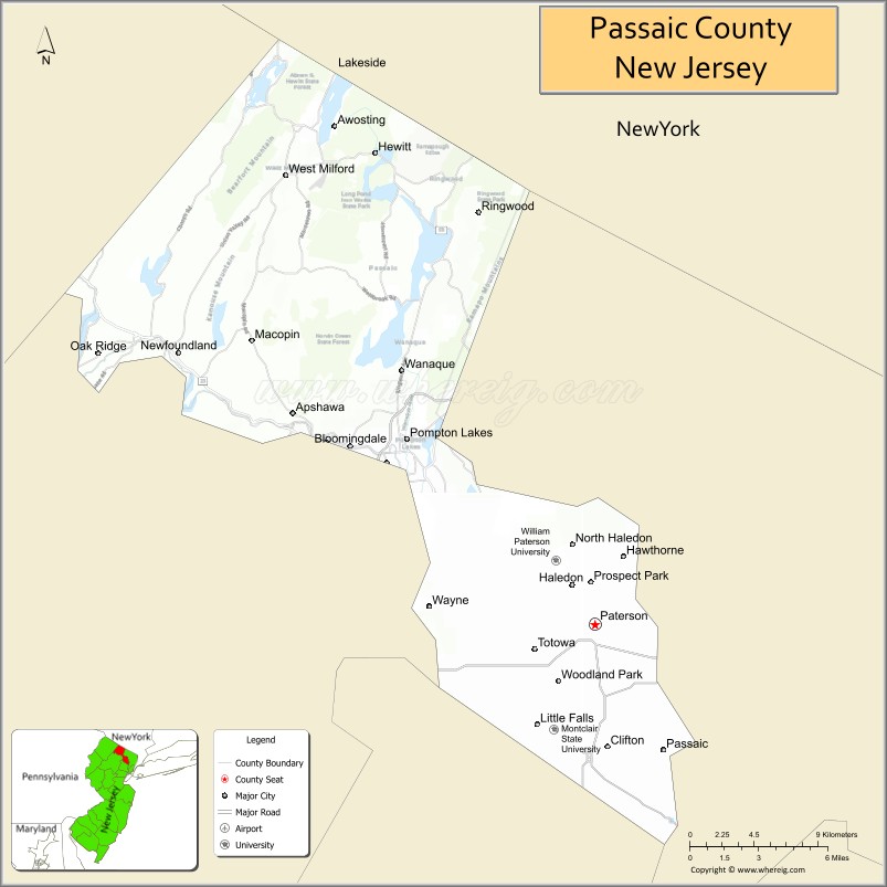
About Passaic County Map, Alabama: The map showing the county boundary, county seat, major cities, highways, water bodies and neighbouring counties.
Other New Jersey Maps & Info
Map of Passaic County, New Jersey
Passaic County is a county located in the U.S. state of New Jersey. It's county seat is Paterson. As per 2020 census, the population of Passaic County is 518117 people and population density is 2800.63 square miles. According to the United States Census Bureau, the county has a total area of 185 sq mi (479 km2). Passaic County was established on 1837.
Passaic County Facts
| Continent | North America |
| Country | United States |
| State | New Jersey |
| County Seat | Paterson |
| Largest City/Town | Paterson |
| Established | 1837 |
| Total Area | 198 sq mi |
| Land Area | 185 sq mi |
| Water Area | 13 sq mi |
| Population | 524,118 (Census 2020) |
| Population Density | 2,830 people per sq mi |
| Time Zone | Eastern (EST) |
| Major Highways | I-80, I-287, US-46, NJ-3, NJ-23 |
| Neighboring Counties | Bergen County, Essex County, Morris County, Sussex County, Rockland County (NY) |
| Famous For | Great Falls of the Passaic River, Paterson, industrial history |
| Top Attractions | Paterson Great Falls, Garret Mountain Reservation, Lambert Castle |
| Official Website | https://www.passaiccountynj.org |
Cities and Towns in Passaic County, New Jersey
- Paterson (county seat) – 159,732 (Census 2020)
- Clifton – 90,296 (Census 2020)
- Passaic – 70,537 (Census 2020)
- Wayne Township – 54,838 (Census 2020)
Roads and Highways in Passaic County, New Jersey
Passaic County is well connected by major highways that link it to New York City and northern New Jersey.
- Interstate 80 (I-80) – Runs east-west connecting the county to Pennsylvania and New York City
- Interstate 287 (I-287) – Major north-south route connecting to surrounding counties
- U.S. Route 46 (US-46) – Connects local communities across North Jersey
- New Jersey Route 3 (NJ-3) – Provides access to the New York metropolitan area
- New Jersey Route 23 (NJ-23) – Connects the county to Sussex County and northern regions
Neighboring Counties of Passaic County
- Bergen County (east)
- Essex County (south)
- Morris County (southwest)
- Sussex County (northwest)
- Rockland County, NY (north)
Top Attractions in Passaic County, New Jersey
Passaic County offers a mix of natural landmarks, parks, and historic sites.
- Paterson Great Falls National Historical Park – One of the largest waterfalls in the U.S.
- Garret Mountain Reservation – Scenic park with trails and city views
- Lambert Castle – Historic castle with museum exhibits
- Ringwood State Park – Large park with gardens, hiking trails, and historic estates
- New Jersey Botanical Garden – Beautiful gardens located in Ringwood
- Dey Mansion – Historic Revolutionary War headquarters
- High Mountain Park Preserve – Natural area with hiking trails and wildlife
Distance from Passaic County to Nearby Cities
- Paterson to New York City – 20 mi (32 km)
- Paterson to Newark – 15 mi (24 km)
- Paterson to Jersey City – 20 mi (32 km)
- Paterson to Trenton – 70 mi (113 km)
- Paterson to Philadelphia – 95 mi (153 km)
FAQs about Passaic County
Passaic County is known for the Great Falls of the Passaic River and its industrial history.
Paterson is the county seat and largest city.
Yes, it is part of the New York City metropolitan area.
Visitors enjoy waterfalls, parks, historic sites, and scenic natural areas.
It is about 20 miles from New York City.
- Atlantic County Map
- Bergen County Map
- Burlington County Map
- Camden County Map
- Cape May County Map
- Cumberland County Map
- Essex County Map
- Gloucester County Map
- Hudson County Map
- Hunterdon County Map
- Mercer County Map
- Middlesex County Map
- Monmouth County Map
- Morris County Map
- Ocean County Map
- Passaic County Map
- Salem County Map
- Somerset County Map
- Sussex County Map
- Union County Map
- Warren County Map
- Alabama Counties
- Alaska boroughs
- Arizona Counties
- Arkansas Counties
- California County Map
- Colorado Counties
- Connecticut Counties
- Delaware Counties
- Florida County Map
- Georgia County Map
- Hawaii Counties
- Idaho Counties
- Illinois Counties
- Indiana Counties
- Iowa Counties
- Kansas Counties
- Kentucky Counties
- Louisiana Counties
- Maine Counties
- Maryland Counties
- Massachusetts Counties
- Michigan County Map
- Minnesota Counties
- Mississippi Counties
- Missouri Counties
- Montana Counties
- Nebraska Counties
- Nevada Counties
- New York Counties
- New Hampshire Counties
- New Jersey Counties
- New Mexico Counties
- North Carolina Counties
- North Dakota Counties
- Ohio County Map
- Oklahoma Counties
- Oregon Counties
- Pennsylvania Counties
- Rhode Island Counties
- South Carolina Counties
- South Dakota Counties
- Map of Tennessee
- Texas County Map
- Utah Counties
- Vermont Counties
- Virginia Counties
- Washington Counties
- West Virginia Counties
- Wisconsin Counties
- Wyoming Counties