Map of Camden County - Camden County is a county located in the U.S. state of New Jersey. Camden County Map showing cities, highways, important places and water bodies. Get Where is Camden County located in the map, major cities in Camden county, population, areas, and places of interest.
Map of Camden County, New Jersey
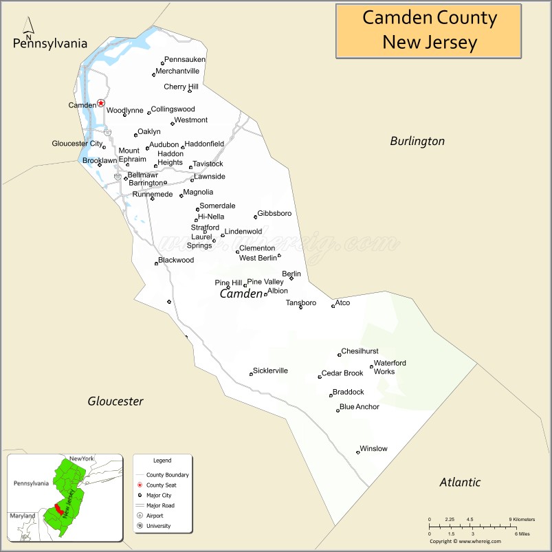
About Camden County Map, Alabama: The map showing the county boundary, county seat, major cities, highways, water bodies and neighbouring counties.
Other New Jersey Maps & Info
Map of Camden County, New Jersey
Camden County is a county located in the U.S. state of New Jersey. It's county seat is Camden. As per 2020 census, the population of Camden County is 523771 people and population density is 2359.33 square miles. According to the United States Census Bureau, the county has a total area of 222 sq mi (575 km2). Camden County was established on 1844.
Camden County Facts
| Continent | North America |
| Country | United States |
| State | New Jersey |
| County Seat | Camden |
| Largest City/Town | Camden |
| Established | 1844 |
| Total Area | 227 sq mi |
| Land Area | 222 sq mi |
| Water Area | 5 sq mi |
| Population | 523,485 (Census 2020) |
| Population Density | 2,358 people per sq mi |
| Time Zone | Eastern (EST) |
| Major Highways | I-76, I-295, NJ Turnpike, US-30, US-130 |
| Neighboring Counties | Burlington County, Gloucester County, Atlantic County |
| Famous For | Camden Waterfront, proximity to Philadelphia, cultural attractions |
| Top Attractions | Adventure Aquarium, Battleship New Jersey, Camden Waterfront |
| Official Website | https://www.camdencounty.com |
Cities and Towns in Camden County, New Jersey
- Camden (county seat) – 71,791 (Census 2020)
- Cherry Hill – 74,553 (Census 2020)
- Pennsauken Township – 37,074 (Census 2020)
- Gloucester Township – 66,034 (Census 2020)
Roads and Highways in Camden County, New Jersey
Camden County is a key transportation hub in South Jersey with direct access to Philadelphia and regional highways.
- Interstate 76 (I-76) – Connects Camden to Philadelphia and western Pennsylvania
- Interstate 295 (I-295) – Runs north-south linking the county to Delaware and Trenton
- New Jersey Turnpike – Major toll road connecting the county to New York and Delaware
- U.S. Route 30 (US-30) – Connects Camden to Atlantic City
- U.S. Route 130 (US-130) – Runs through local communities connecting to central New Jersey
Neighboring Counties of Camden County
- Burlington County (north and east)
- Gloucester County (south)
- Atlantic County (southeast)
Top Attractions in Camden County, New Jersey
Camden County offers a mix of waterfront attractions, parks, and cultural destinations close to Philadelphia.
- Adventure Aquarium – Popular attraction with marine exhibits and interactive displays
- Battleship New Jersey – Historic naval ship museum on the Camden Waterfront
- Camden Waterfront – Scenic area with entertainment and skyline views
- Cooper River Park – Large park with trails, boating, and open space
- Wiggins Waterfront Park – Event space with views of the Philadelphia skyline
- Garden State Discovery Museum (nearby) – Family-friendly interactive exhibits
- Timber Creek Park – Offers hiking trails and nature areas
Distance from Camden County to Nearby Cities
- Camden to Philadelphia – 5 mi (8 km)
- Camden to Atlantic City – 60 mi (97 km)
- Camden to Trenton – 35 mi (56 km)
- Camden to New York City – 95 mi (153 km)
- Camden to Wilmington – 35 mi (56 km)
FAQs about Camden County
Camden County is known for its waterfront attractions, proximity to Philadelphia, and cultural sites.
Camden is the county seat and largest city.
Yes, it is directly across the Delaware River from Philadelphia.
Visitors enjoy the aquarium, waterfront parks, and historic sites like the Battleship New Jersey.
Yes, it is part of the Philadelphia metropolitan area.
- Atlantic County Map
- Bergen County Map
- Burlington County Map
- Camden County Map
- Cape May County Map
- Cumberland County Map
- Essex County Map
- Gloucester County Map
- Hudson County Map
- Hunterdon County Map
- Mercer County Map
- Middlesex County Map
- Monmouth County Map
- Morris County Map
- Ocean County Map
- Passaic County Map
- Salem County Map
- Somerset County Map
- Sussex County Map
- Union County Map
- Warren County Map
- Alabama Counties
- Alaska boroughs
- Arizona Counties
- Arkansas Counties
- California County Map
- Colorado Counties
- Connecticut Counties
- Delaware Counties
- Florida County Map
- Georgia County Map
- Hawaii Counties
- Idaho Counties
- Illinois Counties
- Indiana Counties
- Iowa Counties
- Kansas Counties
- Kentucky Counties
- Louisiana Counties
- Maine Counties
- Maryland Counties
- Massachusetts Counties
- Michigan County Map
- Minnesota Counties
- Mississippi Counties
- Missouri Counties
- Montana Counties
- Nebraska Counties
- Nevada Counties
- New York Counties
- New Hampshire Counties
- New Jersey Counties
- New Mexico Counties
- North Carolina Counties
- North Dakota Counties
- Ohio County Map
- Oklahoma Counties
- Oregon Counties
- Pennsylvania Counties
- Rhode Island Counties
- South Carolina Counties
- South Dakota Counties
- Map of Tennessee
- Texas County Map
- Utah Counties
- Vermont Counties
- Virginia Counties
- Washington Counties
- West Virginia Counties
- Wisconsin Counties
- Wyoming Counties