Map of Union County - Union County is a county located in the U.S. state of New Jersey. Union County Map showing cities, highways, important places and water bodies. Get Where is Union County located in the map, major cities in Union county, population, areas, and places of interest.
Map of Union County, New Jersey
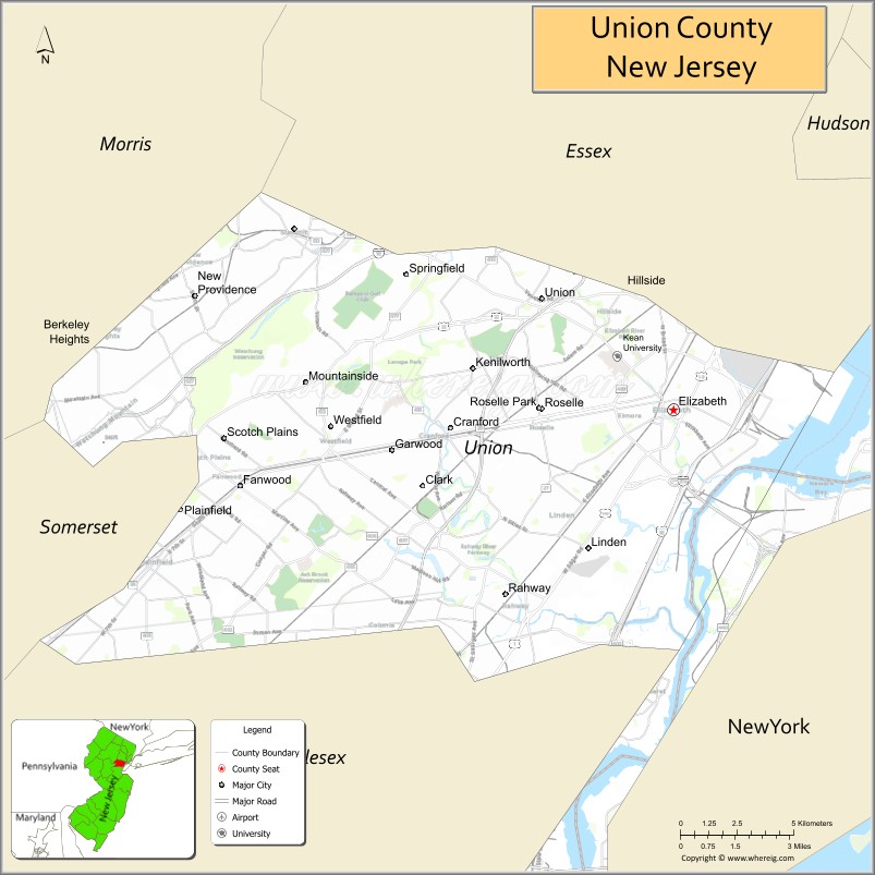
About Union County Map, Alabama: The map showing the county boundary, county seat, major cities, highways, water bodies and neighbouring counties.
Other New Jersey Maps & Info
Map of Union County, New Jersey
Union County is a county located in the U.S. state of New Jersey. It's county seat is Elizabeth. As per 2020 census, the population of Union County is 572114 people and population density is 5554.5 square miles. According to the United States Census Bureau, the county has a total area of 103 sq mi (267 km2). Union County was established on 1857.
Union County Facts
| Continent | North America |
| Country | United States |
| State | New Jersey |
| County Seat | Elizabeth |
| Largest City/Town | Elizabeth |
| Established | 1857 |
| Total Area | 105 sq mi |
| Land Area | 103 sq mi |
| Water Area | 2 sq mi |
| Population | 575,345 (Census 2020) |
| Population Density | 5,585 people per sq mi |
| Time Zone | Eastern (EST) |
| Major Highways | I-95, I-78, Garden State Parkway, US-1/9 |
| Neighboring Counties | Essex County, Middlesex County, Somerset County |
| Famous For | Newark Liberty International Airport (partly), urban communities, proximity to NYC |
| Top Attractions | Watchung Reservation, Warinanco Park, Liberty Hall Museum |
| Official Website | https://ucnj.org |
Cities and Towns in Union County, New Jersey
- Elizabeth (county seat) – 137,298 (Census 2020)
- Union Township – 59,728 (Census 2020)
- Linden – 43,738 (Census 2020)
- Plainfield – 54,586 (Census 2020)
Roads and Highways in Union County, New Jersey
Union County is a key transportation hub with major highways connecting it to New York City and surrounding regions.
- Interstate 95 (I-95) – Part of the New Jersey Turnpike connecting the county to major East Coast cities
- Interstate 78 (I-78) – Runs east-west linking the county to Newark and Pennsylvania
- Garden State Parkway – Connects the county to North and South Jersey
- U.S. Route 1/9 (US-1/9) – Major route linking local communities and the New York metro area
Neighboring Counties of Union County
- Essex County (north)
- Middlesex County (south)
- Somerset County (west)
Top Attractions in Union County, New Jersey
Union County offers parks, historic sites, and cultural attractions close to New York City.
- Watchung Reservation – Large park with trails, nature center, and scenic views
- Warinanco Park – Popular park with lake, gardens, and recreational facilities
- Liberty Hall Museum – Historic home with exhibits and gardens
- Trailside Nature & Science Center – Educational center with nature programs
- Echo Lake Park – Park with walking paths and lake views
- Galloping Hill Golf Course – Well-known public golf course
- Rahway River Park – Scenic park with trails and open space
Distance from Union County to Nearby Cities
- Elizabeth to New York City – 15 mi (24 km)
- Elizabeth to Newark – 5 mi (8 km)
- Elizabeth to Jersey City – 10 mi (16 km)
- Elizabeth to Trenton – 50 mi (80 km)
- Elizabeth to Philadelphia – 85 mi (137 km)
FAQs about Union County
Union County is known for its proximity to New York City, parks, and urban communities.
Elizabeth is the county seat and largest city.
Yes, it is part of the New York City metropolitan area.
Visitors enjoy parks, historic sites, and recreational areas.
It is about 15 miles from New York City.
- Atlantic County Map
- Bergen County Map
- Burlington County Map
- Camden County Map
- Cape May County Map
- Cumberland County Map
- Essex County Map
- Gloucester County Map
- Hudson County Map
- Hunterdon County Map
- Mercer County Map
- Middlesex County Map
- Monmouth County Map
- Morris County Map
- Ocean County Map
- Passaic County Map
- Salem County Map
- Somerset County Map
- Sussex County Map
- Union County Map
- Warren County Map
- Alabama Counties
- Alaska boroughs
- Arizona Counties
- Arkansas Counties
- California County Map
- Colorado Counties
- Connecticut Counties
- Delaware Counties
- Florida County Map
- Georgia County Map
- Hawaii Counties
- Idaho Counties
- Illinois Counties
- Indiana Counties
- Iowa Counties
- Kansas Counties
- Kentucky Counties
- Louisiana Counties
- Maine Counties
- Maryland Counties
- Massachusetts Counties
- Michigan County Map
- Minnesota Counties
- Mississippi Counties
- Missouri Counties
- Montana Counties
- Nebraska Counties
- Nevada Counties
- New York Counties
- New Hampshire Counties
- New Jersey Counties
- New Mexico Counties
- North Carolina Counties
- North Dakota Counties
- Ohio County Map
- Oklahoma Counties
- Oregon Counties
- Pennsylvania Counties
- Rhode Island Counties
- South Carolina Counties
- South Dakota Counties
- Map of Tennessee
- Texas County Map
- Utah Counties
- Vermont Counties
- Virginia Counties
- Washington Counties
- West Virginia Counties
- Wisconsin Counties
- Wyoming Counties