Map of Morris County - Morris County is a county located in the U.S. state of New Jersey. Morris County Map showing cities, highways, important places and water bodies. Get Where is Morris County located in the map, major cities in Morris county, population, areas, and places of interest.
Map of Morris County, New Jersey
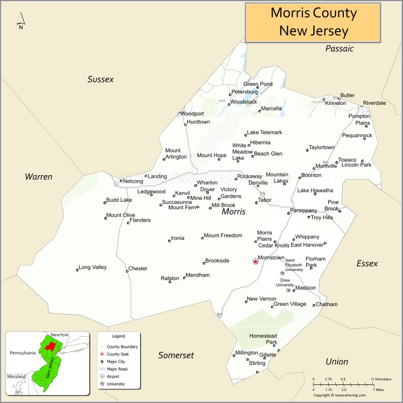
About Morris County Map, Alabama: The map showing the county boundary, county seat, major cities, highways, water bodies and neighbouring counties.
Other New Jersey Maps & Info
Map of Morris County, New Jersey
Morris County is a county located in the U.S. state of New Jersey. It's county seat is Morristown. As per 2020 census, the population of Morris County is 510981 people and population density is 1089.51 square miles. According to the United States Census Bureau, the county has a total area of 469 sq mi (1,215 km2). Morris County was established on 1739.
Morris County Facts
| Continent | North America |
| Country | United States |
| State | New Jersey |
| County Seat | Morristown |
| Largest City/Town | Parsippany-Troy Hills |
| Established | 1739 |
| Total Area | 481 sq mi |
| Land Area | 460 sq mi |
| Water Area | 21 sq mi |
| Population | 509,285 (Census 2020) |
| Population Density | 1,107 people per sq mi |
| Time Zone | Eastern (EST) |
| Major Highways | I-80, I-287, US-46, US-202, NJ-10 |
| Neighboring Counties | Sussex County, Passaic County, Essex County, Union County, Somerset County, Warren County |
| Famous For | Historic sites, Morristown National Historical Park, suburban communities |
| Top Attractions | Morristown National Historical Park, Frelinghuysen Arboretum, Turtle Back Zoo (nearby) |
| Official Website | https://www.morriscountynj.gov |
Cities and Towns in Morris County, New Jersey
- Morristown (county seat) – 20,180 (Census 2020)
- Parsippany-Troy Hills – 56,162 (Census 2020)
- Dover – 18,157 (Census 2020)
- Rockaway Township – 25,673 (Census 2020)
Roads and Highways in Morris County, New Jersey
Morris County is well connected by major highways that provide access to North Jersey and nearby metropolitan areas.
- Interstate 80 (I-80) – Runs east-west connecting the county to Pennsylvania and New York
- Interstate 287 (I-287) – Major north-south route linking Morris County to central and northern New Jersey
- U.S. Route 46 (US-46) – Connects local communities and provides access across North Jersey
- U.S. Route 202 (US-202) – Runs through the county connecting to surrounding regions
- New Jersey Route 10 (NJ-10) – Connects eastern and western parts of the county
Neighboring Counties of Morris County
- Sussex County (northwest)
- Passaic County (north)
- Essex County (east)
- Union County (southeast)
- Somerset County (south)
- Warren County (west)
Top Attractions in Morris County, New Jersey
Morris County offers a mix of historic landmarks, parks, and scenic outdoor destinations.
- Morristown National Historical Park – Key Revolutionary War site with historic buildings
- Frelinghuysen Arboretum – Botanical garden with walking paths and educational programs
- Lewis Morris Park – Large park with trails, lake, and camping areas
- Fosterfields Living Historical Farm – Working farm showcasing 19th-century life
- Tourne County Park – Scenic park with hiking trails and views
- Jockey Hollow – Historic area within the national park
- Historic Speedwell – Site where the telegraph was demonstrated
Distance from Morris County to Nearby Cities
- Morristown to New York City – 30 mi (48 km)
- Morristown to Newark – 20 mi (32 km)
- Morristown to Paterson – 25 mi (40 km)
- Morristown to Trenton – 60 mi (97 km)
- Morristown to Philadelphia – 90 mi (145 km)
FAQs about Morris County
Morris County is known for its Revolutionary War history, parks, and suburban communities.
Morristown is the county seat of Morris County.
Parsippany-Troy Hills is the largest municipality by population.
Yes, it is located in the northern part of New Jersey.
Visitors can explore parks, historic sites, hiking trails, and scenic landscapes.
- Atlantic County Map
- Bergen County Map
- Burlington County Map
- Camden County Map
- Cape May County Map
- Cumberland County Map
- Essex County Map
- Gloucester County Map
- Hudson County Map
- Hunterdon County Map
- Mercer County Map
- Middlesex County Map
- Monmouth County Map
- Morris County Map
- Ocean County Map
- Passaic County Map
- Salem County Map
- Somerset County Map
- Sussex County Map
- Union County Map
- Warren County Map
- Alabama Counties
- Alaska boroughs
- Arizona Counties
- Arkansas Counties
- California County Map
- Colorado Counties
- Connecticut Counties
- Delaware Counties
- Florida County Map
- Georgia County Map
- Hawaii Counties
- Idaho Counties
- Illinois Counties
- Indiana Counties
- Iowa Counties
- Kansas Counties
- Kentucky Counties
- Louisiana Counties
- Maine Counties
- Maryland Counties
- Massachusetts Counties
- Michigan County Map
- Minnesota Counties
- Mississippi Counties
- Missouri Counties
- Montana Counties
- Nebraska Counties
- Nevada Counties
- New York Counties
- New Hampshire Counties
- New Jersey Counties
- New Mexico Counties
- North Carolina Counties
- North Dakota Counties
- Ohio County Map
- Oklahoma Counties
- Oregon Counties
- Pennsylvania Counties
- Rhode Island Counties
- South Carolina Counties
- South Dakota Counties
- Map of Tennessee
- Texas County Map
- Utah Counties
- Vermont Counties
- Virginia Counties
- Washington Counties
- West Virginia Counties
- Wisconsin Counties
- Wyoming Counties