
Ishpeming is a city in Michigan's Upper Peninsula, located in Marquette County about 15 miles west of Marquette. It sits among forested hills of the Marquette Iron Range and is known for its iron-mining history, historic downtown, outdoor recreation, and nearby ski areas. The city also has strong ties to the region's Scandinavian heritage and winter sports.
Location Map of Ishpeming, Marquette County, Michigan
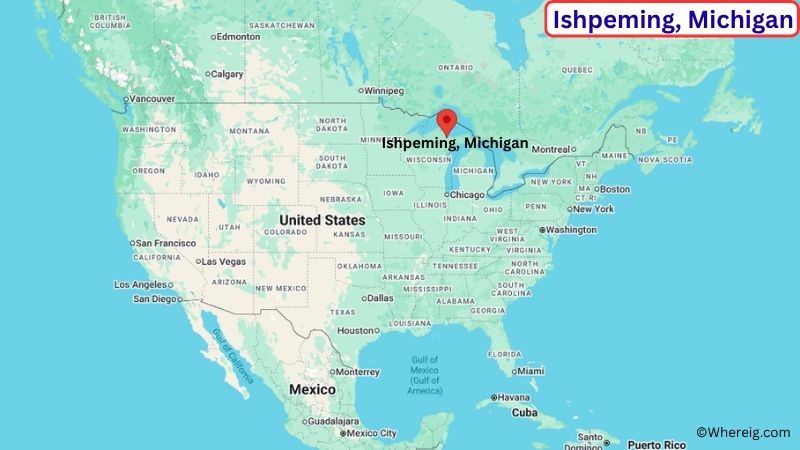
About Map: The map shows the location of Ishpeming in Marquette County, in the U.S. state of Michigan.
Ishpeming Map, Michigan
About Ishpeming Map: The Google Map highlights the location of Ishpeming in Marquette County, Michigan. Use the zoom, satellite, and street-view options to explore the city's neighborhoods, roads, and nearby places.
Where is Ishpeming Located?
Ishpeming is a city located in Marquette County, Michigan, the United States. It lies in Michigan's Upper Peninsula, about 15 miles west of Marquette and roughly 45 miles east of Negaunee. Ishpeming sits in the wooded hills of the Marquette Iron Range, an area shaped by iron mining and timber production. The city is located at approximately 46.488° North latitude and 87.667° West longitude. The 2020 Census recorded 6,074 residents. Ishpeming covers about 9.35 square miles, or 24.22 square kilometers. The city grew rapidly during the 19th century after iron ore was discovered in the surrounding region. Mining remains an important part of its history, while forests, lakes, trails, and winter recreation shape its modern character. One of the city's best-known attractions is the U.S. National Ski Hall of Fame, which recognizes the history and achievements of American skiing. Nearby Suicide Hill is an important ski-jumping site and a major part of Ishpeming's winter sports heritage. A unique feature of the city is its connection to organized ski jumping, which has been part of local life for more than a century. U.S. Highway 41 and Michigan Highway 28 provide connections to Marquette, Negaunee, and other Upper Peninsula communities.
Most Viewed US Maps
| USA Sttae Map | USA Region Map | USA Road Map |
| USA County Map | Where is USA in World Map? | US ZIP Code Map |
| USA Time Zones Map | US State and Capitals Map | USA Physical Map |
Find 4,400+ U.S. Cities by State - Explore Their Locations and Get Detailed Information
Ishpeming City Facts
| City | Ishpeming |
| State | Michigan |
| County | Marquette County |
| Country | United States |
| Region | Central Upper Peninsula |
| Incorporated | 1873 |
| Founded | 1854 |
| Total Area | 9.35 sq mi (24.22 sq km) |
| Land Area | 9.23 sq mi (23.90 sq km) |
| Water Area | 0.12 sq mi (0.31 sq km) |
| Elevation | About 1,500 ft (457 m) |
| Population (2023 estimate) | About 6,000 |
| Population (2020 Census) | 6,074 |
| Population Density | About 658 people per sq mi |
| Time Zone | Eastern Time (ET) |
| ZIP Codes | 49849 |
| Area Code | 906 |
| Major Highways | U.S. Highway 41, M-28, County Road 581 |
| Public Transit | MarqTran |
| Major Attractions | U.S. National Ski Hall of Fame, Suicide Hill Ski Jump, Cliffs Shaft Mine Museum, Lake Superior |
| Official Website | https://www.ishpemingcity.org/ |
Distance from Ishpeming, MI to Nearby Cities
- Negaunee, MI – 5 miles (8 km)
- Marquette, MI – 15 miles (24 km)
- Palmer, MI – 8 miles (13 km)
- Republic, MI – 25 miles (40 km)
- Gwinn, MI – 25 miles (40 km)
- Big Bay, MI – 40 miles (64 km)
- Munising, MI – 55 miles (89 km)
- Iron Mountain, MI – 100 miles (161 km)
- Escanaba, MI – 75 miles (121 km)
- Houghton, MI – 100 miles (161 km)
- Ironwood, MI – 110 miles (177 km)
- Sault Ste. Marie, MI – 125 miles (201 km)
- Menominee, MI – 115 miles (185 km)
- Green Bay, WI – 150 miles (241 km)
- Wausau, WI – 185 miles (298 km)
Top Attractions in Ishpeming
- U.S. National Ski Hall of Fame – A museum and hall of fame dedicated to the history, development, and achievements of skiing in the United States.
- Suicide Hill Ski Jump – A historic ski-jumping facility that has hosted competitions and helped make Ishpeming an important center for the sport.
- Cliffs Shaft Mine Museum – A mining museum preserving the history of iron ore extraction and the people who worked in the Marquette Iron Range.
- Ishpeming Carnegie Public Library – A historic library building that reflects the city's growth during the mining era.
- Lake Superior – The largest of the Great Lakes is a short drive north of Ishpeming and offers beaches, boating, fishing, hiking, and scenic views.
- Presque Isle Park – A scenic Lake Superior park in nearby Marquette featuring wooded trails, rocky shoreline, picnic areas, and views of the lake.
- Marquette Mountain – A nearby ski and recreation area offering winter sports and outdoor activities throughout the year.
- Van Riper State Park – A nearby state park on Lake Michigamme with camping, boating, fishing, swimming, hiking, and forest scenery.
Airports Near Ishpeming
- Sawyer International Airport (MQT) – 30 miles
- Ford Airport (IMT) – 105 miles
- Houghton County Memorial Airport (CMX) – 105 miles
- Delta County Airport (ESC) – 80 miles
- Chippewa County International Airport (CIU) – 135 miles
Sources:
Population and area data sourced from the United States Census Bureau (2020 Census). General city information referenced from the official Ishpeming city website and local government records.
Michigan Related Maps and Info
- Where is Allen Park
- Where is Allendale
- Where is Ann Arbor
- Where is Battle Creek
- Where is Bay City
- Where is Burton
- Where is Dearborn
- Where is Dearborn Heights
- Where is East Lansing
- Where is Eastpointe
- Where is Farmington Hills
- Where is Flint
- Where is Forest Hills
- Where is Garden City
- Where is Grand Rapids
- Where is Hamtramck
- Where is Holland
- Where is Holt
- Where is Inkster
- Where is Jackson
- Where is Kalamazoo
- Where is Kentwood
- Where is Lansing
- Where is Lincoln Park
- Where is Livonia
- Where is Madison Heights
- Where is Midland
- Where is Muskegon
- Where is Novi
- Where is Oak Park
- Where is Okemos
- Where is Pontiac
- Where is Port Huron
- Where is Portage
- Where is Rochester Hills
- Where is Romulus
- Where is Roseville
- Where is Royal Oak
- Where is Saginaw
- Where is Southfield
- Where is Southgate
- Where is St. Clair Shores
- Where is Sterling Heights
- Where is Taylor
- Where is Troy
- Where is Walker
- Where is Warren
- Where is Westland
- Where is Wyoming