
Las Vegas is a historic city in northern New Mexico and the county seat of San Miguel County. Located about 65 miles east of Santa Fe, the city sits along the Gallinas River at the edge of the Sangre de Cristo Mountains. It is known for its preserved Victorian architecture, historic plaza, New Mexico Highlands University, and Santa Fe Trail heritage.
Location Map of Las Vegas, San Miguel County, New Mexico
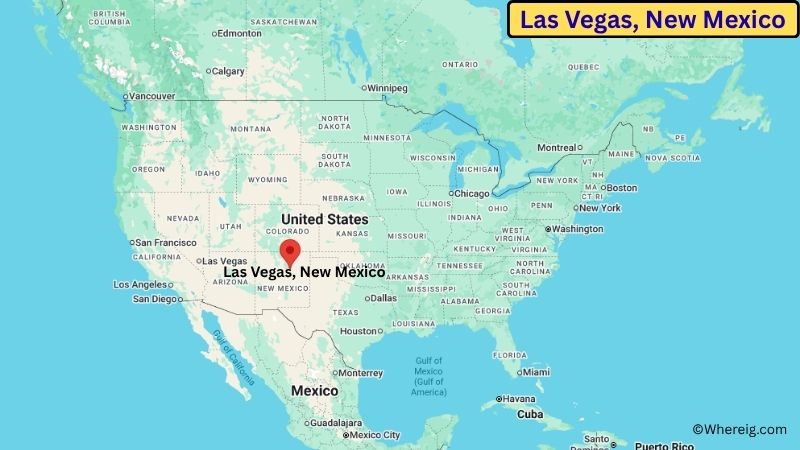
About Map: The map shows the location of Las Vegas in San Miguel County, in the U.S. state of New Mexico.
Las Vegas Map, New Mexico
About Las Vegas Map: The Google Map highlights the location of Las Vegas in San Miguel County, New Mexico. Use the zoom, satellite, and street-view options to explore the city's neighborhoods, roads, and nearby places.
Where is Las Vegas Located?
Las Vegas is a city located in San Miguel County, New Mexico, the United States. It lies in northern New Mexico, about 65 miles east of Santa Fe and roughly 125 miles south of Taos. The city is located at approximately 35.594° North latitude and 105.223° West longitude. The 2020 Census recorded 13,166 residents, and Las Vegas covers about 7.55 square miles (19.55 sq km). The city was founded in 1835 and developed around the historic Las Vegas Plaza, later becoming an important stop along the Santa Fe Trail. A second wave of growth followed the arrival of the railroad in the late 19th century. Today, Las Vegas is known for its large collection of well-preserved Victorian-era buildings and historic homes. One of its most important landmarks is the Las Vegas Plaza, the traditional center of the old town. New Mexico Highlands University is also located in the city and contributes to its educational and cultural life. The surrounding landscape includes the Gallinas River, rolling grasslands, and the nearby Sangre de Cristo Mountains. A unique feature of Las Vegas is its unusually rich collection of historic architecture, with hundreds of structures listed within local and national historic districts. U.S. Route 85 and Interstate 25 provide access to Santa Fe, Albuquerque, Raton, and other northern New Mexico communities.
Most Viewed US Maps
| USA Sttae Map | USA Region Map | USA Road Map |
| USA County Map | Where is USA in World Map? | US ZIP Code Map |
| USA Time Zones Map | US State and Capitals Map | USA Physical Map |
Find 4,400+ U.S. Cities by State - Explore Their Locations and Get Detailed Information
Las Vegas City Facts
| City | Las Vegas |
| State | New Mexico |
| County | San Miguel County |
| Country | United States |
| Region | Northern New Mexico / Sangre de Cristo Mountains |
| Incorporated | 1852 |
| Founded | 1835 |
| Total Area | 7.55 sq mi (19.55 sq km) |
| Land Area | 7.54 sq mi (19.53 sq km) |
| Water Area | 0.01 sq mi (0.03 sq km) |
| Elevation | About 6,430 ft (1,960 m) |
| Population (2023 estimate) | About 13,000 |
| Population (2020 Census) | 13,166 |
| Population Density | About 1,746 people per sq mi |
| Time Zone | Mountain Time (MT) |
| ZIP Codes | 87701, 87731 |
| Area Code | 505 |
| Major Highways | Interstate 25, U.S. Highway 85, New Mexico State Road 65 |
| Public Transit | New Mexico Highlands University and local regional transit services |
| Major Attractions | Las Vegas Plaza, Historic Railroad District, New Mexico Highlands University, Fort Union National Monument |
| Official Website | https://lasvegasnm.gov/ |
Distance from Las Vegas, NM to Nearby Cities
- Ribera, NM – 15 miles (24 km)
- San Miguel, NM – 20 miles (32 km)
- Montezuma, NM – 8 miles (13 km)
- Mora, NM – 25 miles (40 km)
- Santa Fe, NM – 65 miles (105 km)
- Pecos, NM – 35 miles (56 km)
- Raton, NM – 85 miles (137 km)
- Taos, NM – 125 miles (201 km)
- Española, NM – 75 miles (121 km)
- Los Alamos, NM – 75 miles (121 km)
- Albuquerque, NM – 125 miles (201 km)
- Trinidad, CO – 80 miles (129 km)
- Clovis, NM – 175 miles (282 km)
- Roswell, NM – 220 miles (354 km)
- Denver, CO – 300 miles (483 km)
Top Attractions in Las Vegas
- Las Vegas Plaza – The historic heart of the city, surrounded by important buildings and reflecting the community's Spanish and Mexican colonial heritage.
- Historic Railroad District – A collection of historic buildings and neighborhoods that developed after the railroad reached Las Vegas in the 19th century.
- New Mexico Highlands University – A public university with a historic campus, cultural programs, museums, and community events.
- Las Vegas National Wildlife Refuge – A nearby protected area with wetlands, grasslands, wildlife habitat, and opportunities for birdwatching and nature viewing.
- Fort Union National Monument – A major Santa Fe Trail landmark preserving the remains of a large 19th-century U.S. military fort.
- Gallinas Nature Preserve – A local natural area with trails, wildlife habitat, and views of the surrounding landscape.
- Storrie Lake State Park – A nearby recreation area offering fishing, boating, camping, hiking, and mountain views.
- Montezuma Hot Springs – A nearby group of natural hot springs associated with the Gallinas River and historic resort development.
Airports Near Las Vegas
- Las Vegas Municipal Airport (LVS) – 5 miles
- Santa Fe Regional Airport (SAF) – 70 miles
- Taos Regional Airport (SKX) – 125 miles
- Albuquerque International Sunport (ABQ) – 125 miles
- Raton Municipal Airport (RTN) – 85 miles
Sources:
Population and area data sourced from the United States Census Bureau (2020 Census). General city information referenced from the official Las Vegas city website and local government records.
New Mexico Maps & Info
- Where is Alamogordo
- Where is Artesia
- Where is Aztec
- Where is Belen
- Where is Bernalillo
- Where is Bloomfield
- Where is Bosque Farms
- Where is Carlsbad
- Where is Chaparral
- Where is Clovis
- Where is Corrales
- Where is Deming
- Where is Edgewood
- Where is El Cerro Mission
- Where is Eldorado at Santa Fe
- Where is Farmington
- Where is Gallup
- Where is Grants
- Where is Hobbs
- Where is Holloman AFB
- Where is Las Cruces
- Where is Los Alamos
- Where is Los Chaves
- Where is Los Lunas
- Where is Los Ranchos de Albuquerque
- Where is Lovington
- Where is Meadow Lake
- Where is North Hobbs
- Where is North Valley
- Where is Paradise Hills
- Where is Placitas
- Where is Portales
- Where is Raton
- Where is Rio Rancho
- Where is Roswell
- Where is Ruidoso
- Where is Santa Fe
- Where is Santa Teresa
- Where is Shiprock
- Where is Silver City
- Where is Socorro
- Where is South Valley
- Where is Sunland Park
- Where is Taos
- Where is Truth or Consequences
- Where is Tucumcari
- Where is White Rock
- Where is Zuni Pueblo