
Port Angeles is a coastal city on Washington's Olympic Peninsula and the county seat of Clallam County. It sits along the Strait of Juan de Fuca, about 80 miles northwest of Seattle by road. The city is known for its waterfront, Olympic National Park access, ferry connections to Canada, and spectacular views of the Olympic Mountains and Strait.
Location Map of Port Angeles, Clallam County, Washington
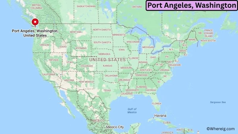
About Map: The map shows the location of Port Angeles in Clallam County, in the U.S. state of Washington.
Port Angeles Map, Washington
About Port Angeles Map: The Google Map highlights the location of Port Angeles in Clallam County, Washington. Use the zoom, satellite, and street-view options to explore the city's neighborhoods, roads, and nearby places.
Where is Port Angeles Located?
Port Angeles is a city located in Clallam County, Washington, the United States. It lies on the northern edge of the Olympic Peninsula along the Strait of Juan de Fuca, about 80 miles northwest of Seattle by road and roughly 45 miles west of Port Townsend. Sequim is around 20 miles east, while Forks is about 55 miles west. Port Angeles is positioned near 48.119° North latitude and 123.430° West longitude. The 2020 Census recorded 19,960 residents. The city covers about 41.78 square miles, or 108.21 square kilometers, including a substantial water area. Port Angeles serves as the county seat of Clallam County and is an important transportation and service center for the Olympic Peninsula. The city was incorporated in 1890 and has a long maritime history connected to fishing, shipping, timber, and trade. Its waterfront provides views across the Strait of Juan de Fuca toward Vancouver Island in British Columbia. The Port Angeles Ferry Terminal offers international ferry service to Victoria, Canada. A major reason visitors come to the area is its proximity to Olympic National Park, a UNESCO World Heritage Site known for temperate rainforests, alpine landscapes, lakes, and rugged Pacific coastline. A unique fact about Port Angeles is that the city is one of the closest U.S. communities to Canada by sea, with Victoria located directly across the Strait. Hurricane Ridge, Lake Crescent, and the Elwha Valley are among the region's major natural attractions. US-101 passes through Port Angeles and connects the city with Sequim, Forks, and other communities around the Olympic Peninsula.
Most Viewed US Maps
| USA Sttae Map | USA Region Map | USA Road Map |
| USA County Map | Where is USA in World Map? | US ZIP Code Map |
| USA Time Zones Map | US State and Capitals Map | USA Physical Map |
Find 4,400+ U.S. Cities by State - Explore Their Locations and Get Detailed Information
Port Angeles City Facts
| City | Port Angeles |
| State | Washington |
| County | Clallam County |
| Country | United States |
| Region | Olympic Peninsula and Pacific Northwest |
| Incorporated | 1890 |
| Founded | 1862 |
| Total Area | 41.78 sq mi (108.21 sq km) |
| Land Area | 10.47 sq mi (27.12 sq km) |
| Water Area | 31.31 sq mi (81.09 sq km) |
| Elevation | 0–500 ft (0–152 m) |
| Population (2023 estimate) | About 20,000 |
| Population (2020 Census) | 19,960 |
| Population Density | 1,906 people per sq mi of land |
| Time Zone | Pacific Time (PST/PDT) |
| ZIP Codes | 98362 |
| Area Code | 360 |
| Major Highways | US-101 and WA-117 |
| Public Transit | Clallam Transit |
| Major Attractions | Olympic National Park, Hurricane Ridge, Port Angeles Waterfront, Olympic Discovery Trail, and Black Ball Ferry Line |
| Official Website | https://www.cityofpa.us/ |
Distance from Port Angeles, WA to Nearby Cities
- Sequim, WA – 20 miles (32 km)
- Port Townsend, WA – 45 miles (72 km)
- Forks, WA – 55 miles (89 km)
- Victoria, BC – 25 miles (40 km) by ferry
- Coupeville, WA – 65 miles (105 km)
- Oak Harbor, WA – 70 miles (113 km)
- Bremerton, WA – 85 miles (137 km)
- Everett, WA – 100 miles (161 km)
- Olympia, WA – 110 miles (177 km)
- Seattle, WA – 80 miles (129 km) by road and ferry routes
- Tacoma, WA – 105 miles (169 km)
- Aberdeen, WA – 130 miles (209 km)
- Bellingham, WA – 140 miles (225 km)
- Mount Vernon, WA – 115 miles (185 km)
- Vancouver, BC – 120 miles (193 km)
- Portland, OR – 225 miles (362 km)
- Wenatchee, WA – 200 miles (322 km)
- Yakima, WA – 220 miles (354 km)
Top Attractions in Port Angeles
- Olympic National Park – A vast national park surrounding much of the Olympic Peninsula, featuring temperate rainforests, mountains, alpine meadows, lakes, and rugged coastline.
- Hurricane Ridge – One of the most popular destinations in Olympic National Park, offering mountain views, hiking trails, snow sports, and scenic overlooks.
- Port Angeles Waterfront – A scenic waterfront area with parks, walking paths, marinas, restaurants, and views across the Strait of Juan de Fuca.
- Olympic Discovery Trail – A regional trail system connecting Port Townsend, Sequim, Port Angeles, and communities across the northern Olympic Peninsula.
- Elwha Valley – A nearby area of Olympic National Park known for forests, rivers, mountain scenery, and the restoration of the Elwha River ecosystem.
- Lake Crescent – A deep, clear mountain lake west of Port Angeles surrounded by forests and Olympic Mountain scenery.
- Feiro Marine Life Center – A waterfront educational center featuring marine-life exhibits and programs about the ecosystems of the Strait of Juan de Fuca.
- Port Angeles Fine Arts Center – A local arts center with exhibitions, outdoor art, and the Webster's Woods Sculpture Park.
Airports Near Port Angeles, WA
- William R. Fairchild International Airport (CLM) – 5 miles
- Victoria International Airport (YYJ) – 50 miles by ferry and road
- William R. Fairchild International Airport – 5 miles
- Seattle-Tacoma International Airport (SEA) – 120 miles by road and ferry
- Portland International Airport (PDX) – 230 miles
Sources:
Population and area data sourced from the United States Census Bureau (2020 Census). General city information referenced from the official Port Angeles city website and local government records.
Washington Maps and Info
- Where is Auburn
- Where is Bellevue
- Where is Bellingham
- Where is Bothell
- Where is Bremerton
- Where is Burien
- Where is Camas
- Where is Edmonds
- Where is Everett
- Where is Federal Way
- Where is Frederickson
- Where is Graham
- Where is Issaquah
- Where is Kennewick
- Where is Kent
- Where is Kirkland
- Where is Lacey
- Where is Lake Stevens
- Where is Lakewood
- Where is Longview
- Where is Lynnwood
- Where is Maple Valley
- Where is Marysville
- Where is Mill Creek East
- Where is Mount Vernon
- Where is Olympia
- Where is Orchards
- Where is Parkland
- Where is Pasco
- Where is Pullman
- Where is Puyallup
- Where is Redmond
- Where is Renton
- Where is Richland
- Where is Sammamish
- Where is SeaTac
- Where is Shoreline
- Where is South Hill
- Where is Spanaway
- Where is Spokane Valley
- Where is Tacoma
- Where is Tumwater
- Where is University Place
- Where is Vancouver
- Where is Walla Walla
- Where is Wenatchee
- Where is Yakima