
Sequim is a city on Washington’s Olympic Peninsula and part of the Port Angeles metropolitan area in Clallam County. Located about 18 miles east of Port Angeles, the city sits near the Strait of Juan de Fuca and the Olympic Mountains. Sequim is known for its mild climate, lavender farms, Dungeness River, and nearby Dungeness National Wildlife Refuge.
Location Map of Sequim, Clallam County, Washington
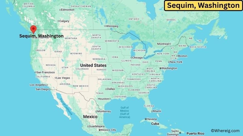
About Map: The map shows the location of Sequim in Clallam County, in the U.S. state of Washington.
Sequim Map, Washington
About Sequim Map: The Google Map highlights the location of Sequim in Clallam County, Washington. Use the zoom, satellite, and street-view options to explore the city's neighborhoods, roads, and nearby places.
Where is Sequim Located?
Sequim is a city located in Clallam County, Washington, the United States. It lies in the northeastern part of the Olympic Peninsula along the Strait of Juan de Fuca. Sequim is about 18 miles east of Port Angeles, 25 miles west of Port Townsend, and roughly 65 miles northwest of Seattle by road and ferry routes. The city is located at 48.0795° North latitude and 123.1018° West longitude. The 2020 Census recorded 8,024 residents. Sequim covers about 6.37 square miles (16.50 square kilometers), with most of the area consisting of land. The city is famous for its lavender farms, which benefit from the area's relatively dry climate caused by the rain shadow of the Olympic Mountains. Dungeness National Wildlife Refuge and the Dungeness River are major nearby natural attractions. A unique feature of Sequim is its unusually dry climate compared with much of western Washington.
Most Viewed US Maps
| USA Sttae Map | USA Region Map | USA Road Map |
| USA County Map | Where is USA in World Map? | US ZIP Code Map |
| USA Time Zones Map | US State and Capitals Map | USA Physical Map |
Find 4,400+ U.S. Cities by State - Explore Their Locations and Get Detailed Information
Sequim City Facts
| Fact | Details |
|---|---|
| City | Sequim |
| State | Washington |
| County | Clallam County |
| Country | United States |
| Region | Olympic Peninsula, Northwestern Washington |
| Incorporated | October 31, 1913 |
| Founded | 1850s |
| Total Area | 6.37 sq mi (16.50 sq km) |
| Land Area | 6.31 sq mi (16.34 sq km) |
| Water Area | 0.06 sq mi (0.16 sq km) |
| Elevation | About 180 ft (55 m) |
| Population (2023 estimate) | About 8,300 |
| Population (2020 Census) | 8,024 |
| Population Density | About 1,270 people per sq mi |
| Time Zone | Pacific Time (PST/PDT) |
| ZIP Codes | 98382 |
| Area Code | 360, 564 |
| Major Highways | U.S. Highway 101, Washington State Route 104, Washington State Route 20 |
| Public Transit | Clallam Transit |
| Major Attractions | Dungeness National Wildlife Refuge, Sequim Lavender Farms, Olympic Discovery Trail, Dungeness Spit |
| Official Website | https://www.sequimwa.gov/ |
Distance from Sequim, WA to Nearby Cities
- Port Angeles, WA – 18 miles (29 km)
- Carlsborg, WA – 5 miles (8 km)
- Port Townsend, WA – 25 miles (40 km)
- Forks, WA – 65 miles (105 km)
- Joyce, WA – 35 miles (56 km)
- Chimacum, WA – 25 miles (40 km)
- Coupeville, WA – 35 miles (56 km)
- Oak Harbor, WA – 45 miles (72 km)
- Friday Harbor, WA – 45 miles (72 km)
- Anacortes, WA – 50 miles (80 km)
- Bellingham, WA – 85 miles (137 km)
- Bremerton, WA – 70 miles (113 km)
- Everett, WA – 85 miles (137 km)
- Edmonds, WA – 90 miles (145 km)
- Tacoma, WA – 110 miles (177 km)
- Seattle, WA – 115 miles (185 km)
- Olympia, WA – 125 miles (201 km)
- Mount Vernon, WA – 70 miles (113 km)
Top Attractions in Sequim, Washington
- Dungeness National Wildlife Refuge – A protected coastal area known for birdwatching, wildlife habitat, beaches, and the famous Dungeness Spit.
- Dungeness Spit – One of the world's longest natural sand spits, extending into the Strait of Juan de Fuca with the historic New Dungeness Lighthouse at its end.
- Sequim Lavender Farms – A collection of farms and fields that showcase the area's lavender-growing tradition, especially during the summer bloom.
- Olympic Discovery Trail – A regional multi-use trail offering walking and cycling routes through Sequim, Port Angeles, and other Olympic Peninsula communities.
- Sequim Museum & Arts – A local museum and cultural center preserving regional history, natural history, art, and community exhibits.
- Dungeness River Nature Center – A nature and education center near the Dungeness River with trails, wildlife habitat, and programs about local ecosystems.
- John Wayne Marina – A marina on Sequim Bay offering boat access, waterfront views, fishing, and outdoor recreation.
- Olympic National Park – A major national park near Sequim featuring old-growth forests, alpine mountains, lakes, rivers, and Pacific coastline.
- New Dungeness Lighthouse – A historic lighthouse at the end of Dungeness Spit that has guided ships through the Strait of Juan de Fuca for more than a century.
Airports Near Sequim, Washington
- William R. Fairchild International Airport (CLM) – 25 miles
- Jefferson County International Airport (0S9) – 30 miles
- Friday Harbor Airport (FHR) – 45 miles
- Victoria International Airport (YYJ) – 55 miles
Sources:
Population and area data sourced from the United States Census Bureau (2020 Census). General city information referenced from the official Sequim city website and local government records.
Washington Maps and Info
- Where is Auburn
- Where is Bellevue
- Where is Bellingham
- Where is Bothell
- Where is Bremerton
- Where is Burien
- Where is Camas
- Where is Edmonds
- Where is Everett
- Where is Federal Way
- Where is Frederickson
- Where is Graham
- Where is Issaquah
- Where is Kennewick
- Where is Kent
- Where is Kirkland
- Where is Lacey
- Where is Lake Stevens
- Where is Lakewood
- Where is Longview
- Where is Lynnwood
- Where is Maple Valley
- Where is Marysville
- Where is Mill Creek East
- Where is Mount Vernon
- Where is Olympia
- Where is Orchards
- Where is Parkland
- Where is Pasco
- Where is Pullman
- Where is Puyallup
- Where is Redmond
- Where is Renton
- Where is Richland
- Where is Sammamish
- Where is SeaTac
- Where is Shoreline
- Where is South Hill
- Where is Spanaway
- Where is Spokane Valley
- Where is Tacoma
- Where is Tumwater
- Where is University Place
- Where is Vancouver
- Where is Walla Walla
- Where is Wenatchee
- Where is Yakima