
Sultan is a small city in western Washington and part of Snohomish County. Located about 35 miles east of Everett, the city sits in the Skykomish River Valley near the Cascade foothills. Sultan is known for its river setting, mountain views, outdoor recreation, historic Main Street, and easy access to the forests and trails of the central Cascades.
Location Map of Sultan, Snohomish County, Washington
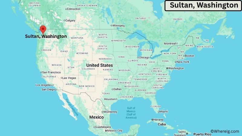
About Map: The map shows the location of Sultan in Snohomish County, in the U.S. state of Washington.
Sultan Map, Washington
About Sultan Map: The Google Map highlights the location of Sultan in Snohomish County, Washington. Use the zoom, satellite, and street-view options to explore the city's neighborhoods, roads, and nearby places.
Where is Sultan Located?
Sultan is a city located in Snohomish County, Washington, the United States. It lies in the Skykomish River Valley of western Washington, about 35 miles east of Everett and roughly 45 miles northeast of Seattle. Monroe is about 10 miles west, while Gold Bar is approximately 5 miles east of Sultan. The city is located at 47.8626° North latitude and 121.8162° West longitude. The 2020 Census recorded 5,146 residents. Sultan covers about 1.62 square miles, or approximately 4.20 square kilometers. The Skykomish River and Sultan River are important geographic features, while the surrounding Cascade foothills are covered with forests and mountains. The Sultan Basin and nearby wilderness areas provide opportunities for hiking, fishing, camping, wildlife viewing, and scenic drives. The city grew from a logging and mining community and later developed as a regional residential center. A unique feature of Sultan is its location at the junction of the Sultan and Skykomish rivers, giving the community a strong connection to the surrounding river valley and Cascade Mountain landscape.
Most Viewed US Maps
| USA Sttae Map | USA Region Map | USA Road Map |
| USA County Map | Where is USA in World Map? | US ZIP Code Map |
| USA Time Zones Map | US State and Capitals Map | USA Physical Map |
Find 4,400+ U.S. Cities by State - Explore Their Locations and Get Detailed Information
Sultan City Facts
| Fact | Details |
|---|---|
| City | Sultan |
| State | Washington |
| County | Snohomish County |
| Country | United States |
| Region | Western Washington, Skykomish River Valley |
| Incorporated | 1905 |
| Founded | 1880s |
| Total Area | 1.62 sq mi (4.20 sq km) |
| Land Area | 1.61 sq mi (4.17 sq km) |
| Water Area | 0.01 sq mi (0.03 sq km) |
| Elevation | About 100 ft (30 m) |
| Population (2023 estimate) | About 5,500 |
| Population (2020 Census) | 5,146 |
| Population Density | About 3,196 people per sq mi |
| Time Zone | Pacific Time (PST/PDT) |
| ZIP Codes | 98294 |
| Area Code | 360 |
| Major Highways | U.S. Route 2, Sultan Basin Road |
| Public Transit | Community Transit |
| Major Attractions | Skykomish River, Sultan Basin, Osprey Park, Wayside Park, Wallace Falls State Park |
| Official Website | https://www.ci.sultan.wa.us/ |
Distance from Sultan, WA to Nearby Cities
- Gold Bar, WA – 5 miles (8 km)
- Monroe, WA – 10 miles (16 km)
- Startup, WA – 5 miles (8 km)
- Snohomish, WA – 15 miles (24 km)
- Lake Stevens, WA – 20 miles (32 km)
- Arlington, WA – 25 miles (40 km)
- Everett, WA – 35 miles (56 km)
- Granite Falls, WA – 25 miles (40 km)
- Marysville, WA – 30 miles (48 km)
- Bothell, WA – 30 miles (48 km)
- Lynnwood, WA – 35 miles (56 km)
- Woodinville, WA – 30 miles (48 km)
- Mill Creek, WA – 30 miles (48 km)
- Bellevue, WA – 45 miles (72 km)
- Seattle, WA – 45 miles (72 km)
- Redmond, WA – 40 miles (64 km)
- Bellingham, WA – 80 miles (129 km)
- Wenatchee, WA – 95 miles (153 km)
Top Attractions in Sultan
- Skykomish River – The river flows through Sultan and provides opportunities for fishing, rafting, kayaking, wildlife viewing, and scenic recreation.
- Sultan Basin – A forested mountain area east of the city with trails, lakes, streams, and access to Cascade foothill scenery.
- Osprey Park – A community park along the river with open space, walking areas, picnic facilities, and views of the surrounding landscape.
- Wayside Park – A local recreation area providing green space and outdoor facilities near the center of Sultan.
- Wallace Falls State Park – A popular nearby state park featuring several waterfalls, forest trails, viewpoints, and hiking opportunities.
- Gold Bar Nature Trails – Nearby trails and natural areas provide access to forests, rivers, and Cascade foothill scenery.
- Historic Sultan Main Street – The city's historic commercial center reflects its early logging, railroad, and river-valley history.
- May Creek Park – A nearby natural area with forested surroundings and opportunities for walking and wildlife observation.
- Mount Baker-Snoqualmie National Forest – Extensive public forestland east of Sultan offers hiking, camping, fishing, wildlife viewing, and mountain recreation.
Airports Near Sultan, Washington
- Paine Field Airport (PAE) – 35 miles
- Seattle-Tacoma International Airport (SEA) – 60 miles
- Bellingham International Airport (BLI) – 80 miles
- King County International Airport (BFI) – 50 miles
- Harvey Field Airport (S43) – 20 miles
Sources:
Population and area data sourced from the United States Census Bureau (2020 Census). General city information referenced from the official Sultan city website and local government records.
Washington Maps and Info
- Where is Auburn
- Where is Bellevue
- Where is Bellingham
- Where is Bothell
- Where is Bremerton
- Where is Burien
- Where is Camas
- Where is Edmonds
- Where is Everett
- Where is Federal Way
- Where is Frederickson
- Where is Graham
- Where is Issaquah
- Where is Kennewick
- Where is Kent
- Where is Kirkland
- Where is Lacey
- Where is Lake Stevens
- Where is Lakewood
- Where is Longview
- Where is Lynnwood
- Where is Maple Valley
- Where is Marysville
- Where is Mill Creek East
- Where is Mount Vernon
- Where is Olympia
- Where is Orchards
- Where is Parkland
- Where is Pasco
- Where is Pullman
- Where is Puyallup
- Where is Redmond
- Where is Renton
- Where is Richland
- Where is Sammamish
- Where is SeaTac
- Where is Shoreline
- Where is South Hill
- Where is Spanaway
- Where is Spokane Valley
- Where is Tacoma
- Where is Tumwater
- Where is University Place
- Where is Vancouver
- Where is Walla Walla
- Where is Wenatchee
- Where is Yakima