Written and Fact-checked by Whereig Editors | Last Updated: May 05, 2026 | 06:30 ET
Map of Linn County - Linn County is a county located in the U.S. state of Kansas. Linn County Map showing cities, highways, important places and water bodies. Get Where is Linn County located in the map, major cities in Linn county, population, areas, and places of interest.
Map of Linn County, Kansas
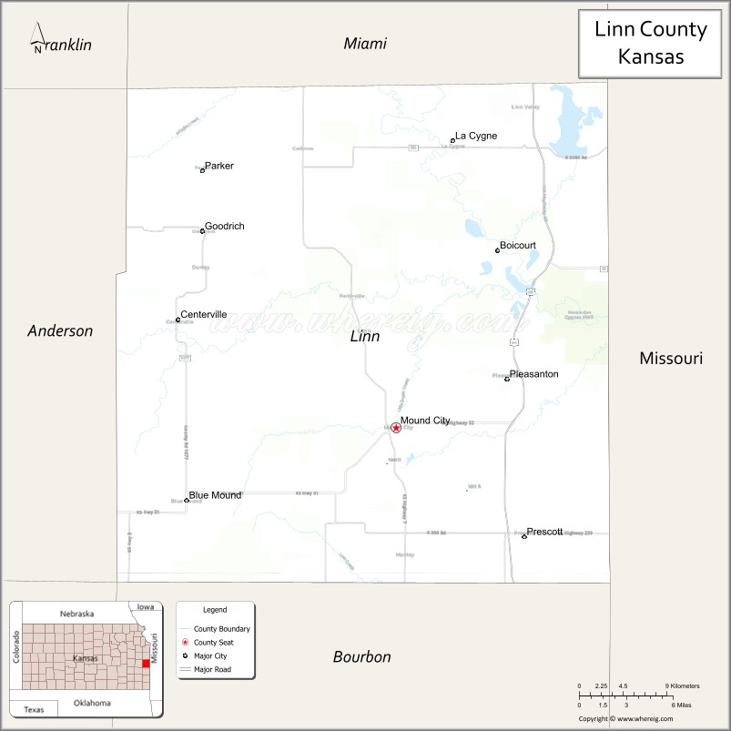
About Linn County Map, Kansas: The map showing the county boundary, county seat, major cities, highways, water bodies and neighbouring counties.
Related Kansas Links
Map of Linn County, Kansas
Linn County is a county located in the U.S. state of Kansas. It's county seat is Mound City. As per 2020 census, the population of Linn County is 9747 people and population density is square miles. According to the United States Census Bureau, the county has a total area of 599 sq mi (1,551 km2). Linn County was established on 1855.
Linn County Facts
| Continent | North America |
| Country | United States |
| State | Kansas |
| County Seat | Mound City |
| Largest City/Town | Pleasanton |
| Established | 1855 |
| Total Area | 595 sq mi (1,541 sq km) |
| Land Area | 593 sq mi (1,536 sq km) |
| Water Area | 2 sq mi (5 sq km) |
| Population | 9,591 (Census 2020) |
| Population Density | 16 people per sq mi |
| Time Zone | Central Time Zone (CT) |
| Major Highways | US-69, K-7, K-52, K-152 |
| Major Rivers | Marais des Cygnes River |
| Neighboring Counties | Miami County, KS; Bourbon County, KS; Crawford County, KS; Vernon County, MO; Bates County, MO |
| Famous For | Bleeding Kansas history, outdoor recreation, lakes and wildlife areas |
| Top Attractions | Marais des Cygnes National Wildlife Refuge, Linn County State Park, Trading Post Museum |
| Official Website | Official Website |
About Linn County, Kansas
Linn County is located in the eastern part of Kansas, in the state of the United States, and was established in 1855. The county seat is Mound City, while Pleasanton is the largest city. The county features rolling hills, river valleys, and several lakes, and it played a key role in the Bleeding Kansas period before the Civil War.
Cities and Towns in Linn County, Kansas
| City/Town | Population (Census 2020) | Latitude & Longitude |
|---|---|---|
| Pleasanton | 1,208 | 38.1795°N, 94.7086°W |
| Mound City (county seat) | 647 | 38.1325°N, 94.8122°W |
| La Cygne | 1,070 | 38.3478°N, 94.7636°W |
| Parker | 241 | 38.3281°N, 94.9889°W |
| Blue Mound | 243 | 38.0892°N, 95.0097°W |
| Lacygne (CDP) | 150 | 38.3500°N, 94.7600°W |
Golf Courses in Linn County, Kansas
| Golf Course | Location | Latitude & Longitude |
|---|---|---|
| Linn Valley Lakes Golf Course | Linn Valley | 38.3835°N, 94.7140°W |
| Jayhawk Hills Golf Course | Mound City | 38.1345°N, 94.8150°W |
Roads and Highways in Linn County, Kansas
The county is connected by highways that provide access to eastern Kansas and neighboring states.
- US-69 – major north-south route connecting the county to Kansas City and Oklahoma
- K-7 – runs north-south linking local communities
- K-52 – east-west highway connecting to nearby counties
- K-152 – provides local connectivity within the county
Neighboring Counties of Linn County
- Miami County, Kansas (north)
- Bourbon County, Kansas (south)
- Crawford County, Kansas (southwest)
- Bates County, Missouri (east)
- Vernon County, Missouri (southeast)
Top Attractions in Linn County, Kansas
The county offers a variety of outdoor and historical attractions.
- Marais des Cygnes National Wildlife Refuge – protected area with diverse wildlife and scenic trails
- Linn County State Park – camping, boating, and fishing opportunities
- Trading Post Museum – historic site linked to early frontier history
- La Cygne Lake – popular for fishing and boating
- Jayhawk Hills Golf Course – recreational golf with scenic surroundings
- Pleasanton City Park – family-friendly outdoor space
- Blue Mound Trail – local hiking and nature area
Distance from Linn County to Nearby Cities
- Mound City to Kansas City – 60 mi (97 km)
- Mound City to Pittsburg – 50 mi (80 km)
- Mound City to Fort Scott – 40 mi (64 km)
- Mound City to Topeka – 90 mi (145 km)
- Mound City to Springfield – 120 mi (193 km)
FAQs about Linn County
Linn County is located in eastern Kansas along the Missouri border in the United States.
The population of Linn County was 9,591 according to the 2020 Census.
The county is known for its role in Bleeding Kansas history, scenic landscapes, and outdoor recreation areas.
Major highways include US-69, K-7, K-52, and K-152.
Yes, Linn County has golf courses such as Linn Valley Lakes Golf Course and Jayhawk Hills Golf Course.
- Allen County Map
- Anderson County Map
- Atchison County Map
- Barber County Map
- Barton County Map
- Bourbon County Map
- Brown County Map
- Butler County Map
- Chase County Map
- Chautauqua County Map
- Cherokee County Map
- Cheyenne County Map
- Clark County Map
- Clay County Map
- Cloud County Map
- Coffey County Map
- Comanche County Map
- Cowley County Map
- Crawford County Map
- Decatur County Map
- Dickinson County Map
- Doniphan County Map
- Douglas County Map
- Edwards County Map
- Elk County Map
- Ellis County Map
- Ellsworth County Map
- Finney County Map
- Ford County Map
- Franklin County Map
- Geary County Map
- Gove County Map
- Graham County Map
- Grant County Map
- Gray County Map
- Greeley County Map
- Greenwood County Map
- Hamilton County Map
- Harper County Map
- Harvey County Map
- Haskell County Map
- Hodgeman County Map
- Jackson County Map
- Jefferson County Map
- Jewell County Map
- Johnson County Map
- Kearny County Map
- Kingman County Map
- Kiowa County Map
- Labette County Map
- Lane County Map
- Leavenworth County Map
- Lincoln County Map
- Linn County Map
- Logan County Map
- Lyon County Map
- McPherson County Map
- Marion County Map
- Marshall County Map
- Meade County Map
- Miami County Map
- Mitchell County Map
- Montgomery County Map
- Morris County Map
- Morton County Map
- Nemaha County Map
- Neosho County Map
- Ness County Map
- Norton County Map
- Osage County Map
- Osborne County Map
- Ottawa County Map
- Pawnee County Map
- Phillips County Map
- Pottawatomie County Map
- Pratt County Map
- Rawlins County Map
- Reno County Map
- Republic County Map
- Rice County Map
- Riley County Map
- Rooks County Map
- Rush County Map
- Russell County Map
- Saline County Map
- Scott County Map
- Sedgwick County Map
- Seward County Map
- Shawnee County Map
- Sheridan County Map
- Sherman County Map
- Smith County Map
- Stafford County Map
- Stanton County Map
- Stevens County Map
- Sumner County Map
- Thomas County Map
- Trego County Map
- Wabaunsee County Map
- Wallace County Map
- Washington County Map
- Wichita County Map
- Wilson County Map
- Woodson County Map
- Wyandotte County Map
- Alabama Counties
- Alaska boroughs
- Arizona Counties
- Arkansas Counties
- California County Map
- Colorado Counties
- Connecticut Counties
- Delaware Counties
- Florida County Map
- Georgia County Map
- Hawaii Counties
- Idaho Counties
- Illinois Counties
- Indiana Counties
- Iowa Counties
- Kansas Counties
- Kentucky Counties
- Louisiana Counties
- Maine Counties
- Maryland Counties
- Massachusetts Counties
- Michigan County Map
- Minnesota Counties
- Mississippi Counties
- Missouri Counties
- Montana Counties
- Nebraska Counties
- Nevada Counties
- New York Counties
- New Hampshire Counties
- New Jersey Counties
- New Mexico Counties
- North Carolina Counties
- North Dakota Counties
- Ohio County Map
- Oklahoma Counties
- Oregon Counties
- Pennsylvania Counties
- Rhode Island Counties
- South Carolina Counties
- South Dakota Counties
- Map of Tennessee
- Texas County Map
- Utah Counties
- Vermont Counties
- Virginia Counties
- Washington Counties
- West Virginia Counties
- Wisconsin Counties
- Wyoming Counties