Written and Fact-checked by Whereig Editors | Last Updated: May 05, 2026 | 06:30 ET
Map of Neosho County - Neosho County is a county located in the U.S. state of Kansas. Neosho County Map showing cities, highways, important places and water bodies. Get Where is Neosho County located in the map, major cities in Neosho county, population, areas, and places of interest.
Map of Neosho County, Kansas
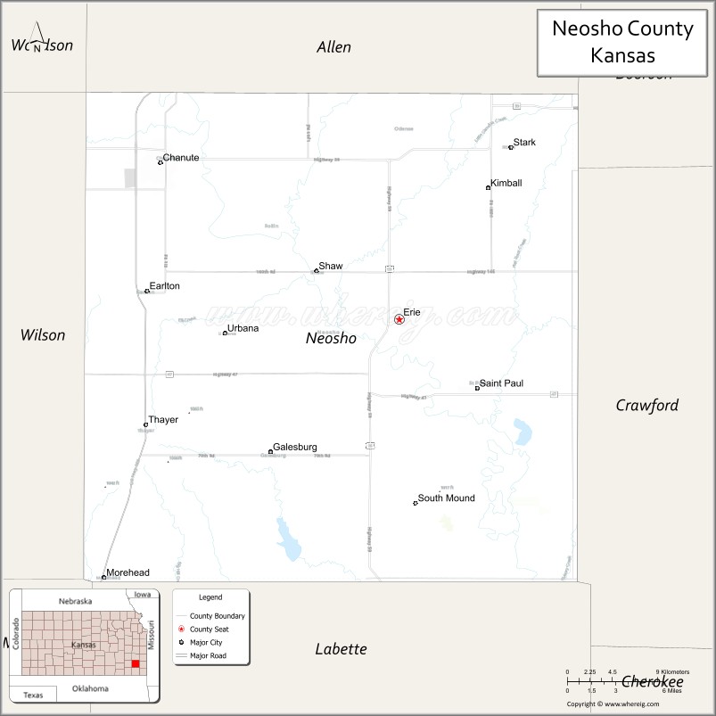
About Neosho County Map, Kansas: The map showing the county boundary, county seat, major cities, highways, water bodies and neighbouring counties.
Related Kansas Links
Map of Neosho County, Kansas
Neosho County is a county located in the U.S. state of Kansas. It's county seat is Erie. As per 2020 census, the population of Neosho County is 15784 people and population density is square miles. According to the United States Census Bureau, the county has a total area of 572 sq mi (1,481 km2). Neosho County was established on 1855.
Neosho County Facts
| Continent | North America |
| Country | United States |
| State | Kansas |
| County Seat | Erie |
| Largest City/Town | Chanute |
| Established | 1861 |
| Total Area | 578 sq mi (1,497 sq km) |
| Land Area | 571 sq mi (1,479 sq km) |
| Water Area | 7 sq mi (18 sq km) |
| Population | 15,904 (Census 2020) |
| Population Density | 28 people per sq mi |
| Time Zone | Central Time Zone (CT) |
| Major Highways | US-169, US-59, K-39, K-47, K-57 |
| Major Rivers | Neosho River |
| Neighboring Counties | Allen County, KS; Bourbon County, KS; Crawford County, KS; Labette County, KS; Wilson County, KS; Woodson County, KS |
| Famous For | Oil and gas history, agriculture, small-town communities |
| Top Attractions | Martin and Osa Johnson Safari Museum, Santa Fe Park, Neosho County State Lake |
| Official Website | Official Website |
About Neosho County, Kansas
Neosho County is located in the southeastern part of Kansas, in the state of the United States, and was established in 1861. The county seat is Erie, while Chanute is the largest city. The county lies within a region of rolling hills and river valleys and has a history tied to agriculture and the oil industry.
Cities and Towns in Neosho County, Kansas
| City/Town | Population (Census 2020) | Latitude & Longitude |
|---|---|---|
| Chanute | 8,722 | 37.6792°N, 95.4572°W |
| Erie (county seat) | 1,047 | 37.5689°N, 95.2431°W |
| St. Paul | 603 | 37.5256°N, 95.1736°W |
| Galesburg | 119 | 37.4700°N, 95.3442°W |
| Thayer | 497 | 37.4831°N, 95.4742°W |
| Urbana | 26 | 37.5403°N, 95.3192°W |
| South Mound (CDP) | 120 | 37.6000°N, 95.4000°W |
Golf Courses in Neosho County, Kansas
| Golf Course | Location | Latitude & Longitude |
|---|---|---|
| Stone Creek Golf Course | Chanute | 37.6825°N, 95.4605°W |
| Erie Golf Course | Erie | 37.5705°N, 95.2455°W |
Roads and Highways in Neosho County, Kansas
The county is served by several highways that connect it to southeastern Kansas and surrounding regions.
- US-169 – major north-south route connecting Chanute to Iola and Coffeyville
- US-59 – runs north-south linking the county to Ottawa and Parsons
- K-39 – east-west route connecting local communities
- K-47 – connects Erie to Chanute and surrounding areas
- K-57 – provides regional connectivity across the county
Neighboring Counties of Neosho County
- Allen County, Kansas (north)
- Woodson County, Kansas (northwest)
- Wilson County, Kansas (west)
- Labette County, Kansas (south)
- Crawford County, Kansas (east)
- Bourbon County, Kansas (northeast)
Top Attractions in Neosho County, Kansas
The county offers historical and recreational attractions.
- Martin and Osa Johnson Safari Museum – museum dedicated to famous explorers and filmmakers
- Santa Fe Park – large park in Chanute with trails and recreation
- Neosho County State Lake – popular for fishing, camping, and outdoor activities
- Chanute Downtown – historic area with shops and local culture
- Erie City Park – local park with recreational facilities
- St. Paul Downtown – small-town charm and historic buildings
- Neosho River – scenic river for outdoor recreation
Distance from Neosho County to Nearby Cities
- Chanute to Wichita – 100 mi (161 km)
- Chanute to Kansas City – 140 mi (225 km)
- Chanute to Tulsa – 90 mi (145 km)
- Chanute to Joplin – 80 mi (129 km)
- Chanute to Topeka – 130 mi (209 km)
FAQs about Neosho County
Neosho County is located in southeastern Kansas in the United States.
The population of Neosho County was 15,904 according to the 2020 Census.
The county is known for its oil history, agriculture, and local museums such as the Martin and Osa Johnson Safari Museum.
Major highways include US-169, US-59, K-39, K-47, and K-57.
Yes, Neosho County has golf courses such as Stone Creek Golf Course and Erie Golf Course.
- Allen County Map
- Anderson County Map
- Atchison County Map
- Barber County Map
- Barton County Map
- Bourbon County Map
- Brown County Map
- Butler County Map
- Chase County Map
- Chautauqua County Map
- Cherokee County Map
- Cheyenne County Map
- Clark County Map
- Clay County Map
- Cloud County Map
- Coffey County Map
- Comanche County Map
- Cowley County Map
- Crawford County Map
- Decatur County Map
- Dickinson County Map
- Doniphan County Map
- Douglas County Map
- Edwards County Map
- Elk County Map
- Ellis County Map
- Ellsworth County Map
- Finney County Map
- Ford County Map
- Franklin County Map
- Geary County Map
- Gove County Map
- Graham County Map
- Grant County Map
- Gray County Map
- Greeley County Map
- Greenwood County Map
- Hamilton County Map
- Harper County Map
- Harvey County Map
- Haskell County Map
- Hodgeman County Map
- Jackson County Map
- Jefferson County Map
- Jewell County Map
- Johnson County Map
- Kearny County Map
- Kingman County Map
- Kiowa County Map
- Labette County Map
- Lane County Map
- Leavenworth County Map
- Lincoln County Map
- Linn County Map
- Logan County Map
- Lyon County Map
- McPherson County Map
- Marion County Map
- Marshall County Map
- Meade County Map
- Miami County Map
- Mitchell County Map
- Montgomery County Map
- Morris County Map
- Morton County Map
- Nemaha County Map
- Neosho County Map
- Ness County Map
- Norton County Map
- Osage County Map
- Osborne County Map
- Ottawa County Map
- Pawnee County Map
- Phillips County Map
- Pottawatomie County Map
- Pratt County Map
- Rawlins County Map
- Reno County Map
- Republic County Map
- Rice County Map
- Riley County Map
- Rooks County Map
- Rush County Map
- Russell County Map
- Saline County Map
- Scott County Map
- Sedgwick County Map
- Seward County Map
- Shawnee County Map
- Sheridan County Map
- Sherman County Map
- Smith County Map
- Stafford County Map
- Stanton County Map
- Stevens County Map
- Sumner County Map
- Thomas County Map
- Trego County Map
- Wabaunsee County Map
- Wallace County Map
- Washington County Map
- Wichita County Map
- Wilson County Map
- Woodson County Map
- Wyandotte County Map
- Alabama Counties
- Alaska boroughs
- Arizona Counties
- Arkansas Counties
- California County Map
- Colorado Counties
- Connecticut Counties
- Delaware Counties
- Florida County Map
- Georgia County Map
- Hawaii Counties
- Idaho Counties
- Illinois Counties
- Indiana Counties
- Iowa Counties
- Kansas Counties
- Kentucky Counties
- Louisiana Counties
- Maine Counties
- Maryland Counties
- Massachusetts Counties
- Michigan County Map
- Minnesota Counties
- Mississippi Counties
- Missouri Counties
- Montana Counties
- Nebraska Counties
- Nevada Counties
- New York Counties
- New Hampshire Counties
- New Jersey Counties
- New Mexico Counties
- North Carolina Counties
- North Dakota Counties
- Ohio County Map
- Oklahoma Counties
- Oregon Counties
- Pennsylvania Counties
- Rhode Island Counties
- South Carolina Counties
- South Dakota Counties
- Map of Tennessee
- Texas County Map
- Utah Counties
- Vermont Counties
- Virginia Counties
- Washington Counties
- West Virginia Counties
- Wisconsin Counties
- Wyoming Counties