Written and Fact-checked by Whereig Editors | Last Updated: May 05, 2026 | 06:30 ET
Map of Riley County - Riley County is a county located in the U.S. state of Kansas. Riley County Map showing cities, highways, important places and water bodies. Get Where is Riley County located in the map, major cities in Riley county, population, areas, and places of interest.
Map of Riley County, Kansas
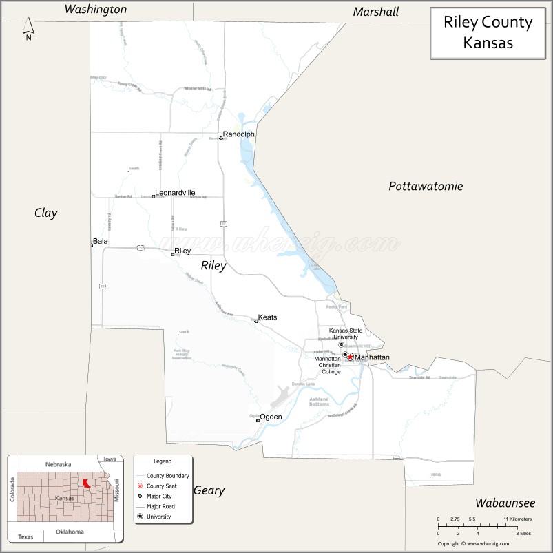
About Riley County Map, Kansas: The map showing the county boundary, county seat, major cities, highways, water bodies and neighbouring counties.
Related Kansas Links
Map of Riley County, Kansas
Riley County is a county located in the U.S. state of Kansas. It's county seat is Manhattan. As per 2020 census, the population of Riley County is 72208 people and population density is square miles. According to the United States Census Bureau, the county has a total area of 610 sq mi (1,580 km2). Riley County was established on 1855.
Riley County Facts
| Continent | North America |
| Country | United States |
| State | Kansas |
| County Seat | Manhattan |
| Largest City/Town | Manhattan |
| Established | 1855 |
| Total Area | 622 sq mi (1,611 sq km) |
| Land Area | 610 sq mi (1,580 sq km) |
| Water Area | 12 sq mi (31 sq km) |
| Population | 71,959 (Census 2020) |
| Population Density | 118 people per sq mi |
| Time Zone | Central Time Zone (CT) |
| Major Highways | US-24, K-18, K-13, K-177 |
| Major Rivers | Kansas River (Kaw River), Big Blue River |
| Neighboring Counties | Washington County, KS; Marshall County, KS; Pottawatomie County, KS; Wabaunsee County, KS; Geary County, KS; Clay County, KS |
| Famous For | Kansas State University, college town atmosphere, Flint Hills region |
| Top Attractions | Kansas State University, Sunset Zoo, Tuttle Creek Lake, Flint Hills Discovery Center |
| Official Website | Official Website |
About Riley County, Kansas
Riley County is located in the northeastern part of Kansas, in the state of the United States, and was established in 1855. The county seat is Manhattan, which is also the largest city. The county lies within the Flint Hills region and is known for its vibrant college-town environment, scenic landscapes, and growing economy.
Cities and Towns in Riley County, Kansas
| City/Town | Population (Census 2020) | Latitude & Longitude |
|---|---|---|
| Manhattan (county seat) | 54,100 | 39.1836°N, 96.5717°W |
| Riley | 939 | 39.2989°N, 96.8336°W |
| Ogden | 2,087 | 39.1111°N, 96.7067°W |
| Leonardville | 449 | 39.3650°N, 96.8456°W |
| Randolph | 163 | 39.4392°N, 96.7797°W |
Golf Courses in Riley County, Kansas
| Golf Course | Location | Latitude & Longitude |
|---|---|---|
| Colbert Hills Golf Course | Manhattan | 39.1865°N, 96.5745°W |
| Stagg Hill Golf Club | Manhattan | 39.1805°N, 96.5755°W |
Roads and Highways in Riley County, Kansas
The county is well connected by highways that support travel across northeastern Kansas.
- US-24 – major east-west route connecting Manhattan to Topeka and Clay Center
- K-18 – runs east-west linking the county to Junction City and other areas
- K-13 – provides access to Tuttle Creek Lake
- K-177 – north-south highway connecting the Flint Hills region
Neighboring Counties of Riley County
- Washington County, Kansas (north)
- Marshall County, Kansas (northeast)
- Pottawatomie County, Kansas (east)
- Wabaunsee County, Kansas (south)
- Geary County, Kansas (southwest)
- Clay County, Kansas (west)
Top Attractions in Riley County, Kansas
The county offers cultural attractions and outdoor recreation.
- Kansas State University – major public university and cultural hub
- Sunset Zoo – family-friendly zoo with diverse animal exhibits
- Tuttle Creek Lake – large reservoir for boating, fishing, and camping
- Flint Hills Discovery Center – interactive museum about the Flint Hills ecosystem
- Manhattan City Park – scenic park with trails and historic features
- Konza Prairie Biological Station – protected prairie for research and hiking
- Downtown Manhattan – vibrant area with shops, dining, and events
Distance from Riley County to Nearby Cities
- Manhattan to Topeka – 50 mi (80 km)
- Manhattan to Salina – 55 mi (89 km)
- Manhattan to Kansas City – 120 mi (193 km)
- Manhattan to Wichita – 130 mi (209 km)
- Manhattan to Lincoln, NE – 120 mi (193 km)
FAQs about Riley County
Riley County is located in northeastern Kansas in the Flint Hills region of the United States.
The population of Riley County was 71,959 according to the 2020 Census.
The county is known for Kansas State University, its college-town atmosphere, and the Flint Hills landscape.
Major highways include US-24, K-18, K-13, and K-177.
Yes, Riley County has golf courses such as Colbert Hills Golf Course and Stagg Hill Golf Club.
- Allen County Map
- Anderson County Map
- Atchison County Map
- Barber County Map
- Barton County Map
- Bourbon County Map
- Brown County Map
- Butler County Map
- Chase County Map
- Chautauqua County Map
- Cherokee County Map
- Cheyenne County Map
- Clark County Map
- Clay County Map
- Cloud County Map
- Coffey County Map
- Comanche County Map
- Cowley County Map
- Crawford County Map
- Decatur County Map
- Dickinson County Map
- Doniphan County Map
- Douglas County Map
- Edwards County Map
- Elk County Map
- Ellis County Map
- Ellsworth County Map
- Finney County Map
- Ford County Map
- Franklin County Map
- Geary County Map
- Gove County Map
- Graham County Map
- Grant County Map
- Gray County Map
- Greeley County Map
- Greenwood County Map
- Hamilton County Map
- Harper County Map
- Harvey County Map
- Haskell County Map
- Hodgeman County Map
- Jackson County Map
- Jefferson County Map
- Jewell County Map
- Johnson County Map
- Kearny County Map
- Kingman County Map
- Kiowa County Map
- Labette County Map
- Lane County Map
- Leavenworth County Map
- Lincoln County Map
- Linn County Map
- Logan County Map
- Lyon County Map
- McPherson County Map
- Marion County Map
- Marshall County Map
- Meade County Map
- Miami County Map
- Mitchell County Map
- Montgomery County Map
- Morris County Map
- Morton County Map
- Nemaha County Map
- Neosho County Map
- Ness County Map
- Norton County Map
- Osage County Map
- Osborne County Map
- Ottawa County Map
- Pawnee County Map
- Phillips County Map
- Pottawatomie County Map
- Pratt County Map
- Rawlins County Map
- Reno County Map
- Republic County Map
- Rice County Map
- Riley County Map
- Rooks County Map
- Rush County Map
- Russell County Map
- Saline County Map
- Scott County Map
- Sedgwick County Map
- Seward County Map
- Shawnee County Map
- Sheridan County Map
- Sherman County Map
- Smith County Map
- Stafford County Map
- Stanton County Map
- Stevens County Map
- Sumner County Map
- Thomas County Map
- Trego County Map
- Wabaunsee County Map
- Wallace County Map
- Washington County Map
- Wichita County Map
- Wilson County Map
- Woodson County Map
- Wyandotte County Map
- Alabama Counties
- Alaska boroughs
- Arizona Counties
- Arkansas Counties
- California County Map
- Colorado Counties
- Connecticut Counties
- Delaware Counties
- Florida County Map
- Georgia County Map
- Hawaii Counties
- Idaho Counties
- Illinois Counties
- Indiana Counties
- Iowa Counties
- Kansas Counties
- Kentucky Counties
- Louisiana Counties
- Maine Counties
- Maryland Counties
- Massachusetts Counties
- Michigan County Map
- Minnesota Counties
- Mississippi Counties
- Missouri Counties
- Montana Counties
- Nebraska Counties
- Nevada Counties
- New York Counties
- New Hampshire Counties
- New Jersey Counties
- New Mexico Counties
- North Carolina Counties
- North Dakota Counties
- Ohio County Map
- Oklahoma Counties
- Oregon Counties
- Pennsylvania Counties
- Rhode Island Counties
- South Carolina Counties
- South Dakota Counties
- Map of Tennessee
- Texas County Map
- Utah Counties
- Vermont Counties
- Virginia Counties
- Washington Counties
- West Virginia Counties
- Wisconsin Counties
- Wyoming Counties