Written and Fact-checked by Whereig Editors | Last Updated: May 05, 2026 | 06:30 ET
Map of Sedgwick County - Sedgwick County is a county located in the U.S. state of Kansas. Sedgwick County Map showing cities, highways, important places and water bodies. Get Where is Sedgwick County located in the map, major cities in Sedgwick county, population, areas, and places of interest.
Map of Sedgwick County, Kansas
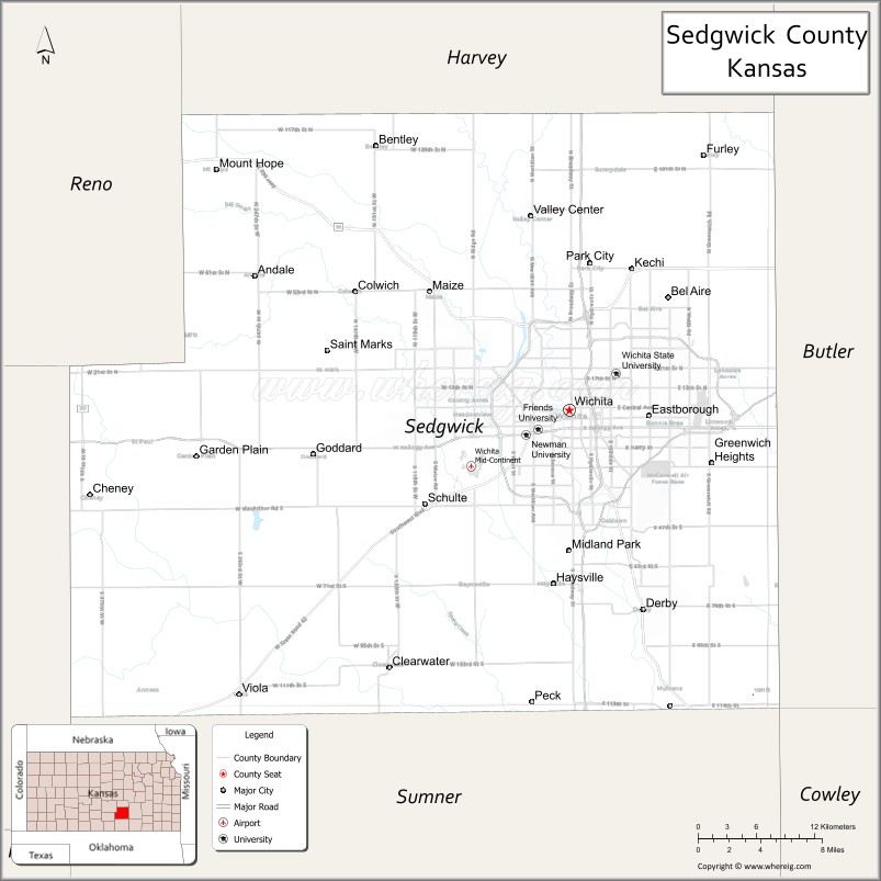
About Sedgwick County Map, Kansas: The map showing the county boundary, county seat, major cities, highways, water bodies and neighbouring counties.
Related Kansas Links
Map of Sedgwick County, Kansas
Sedgwick County is a county located in the U.S. state of Kansas. It's county seat is Wichita. As per 2020 census, the population of Sedgwick County is 523828 people and population density is square miles. According to the United States Census Bureau, the county has a total area of 1,000 sq mi (2,590 km2). Sedgwick County was established on 1867.
Sedgwick County Facts
| Continent | North America |
| Country | United States |
| State | Kansas |
| County Seat | Wichita |
| Largest City/Town | Wichita |
| Established | 1867 |
| Total Area | 1,009 sq mi (2,613 sq km) |
| Land Area | 998 sq mi (2,585 sq km) |
| Water Area | 11 sq mi (28 sq km) |
| Population | 523,824 (Census 2020) |
| Population Density | 525 people per sq mi |
| Time Zone | Central Time Zone (CT) |
| Major Highways | I-35, I-135, US-54, US-81, US-400, K-96 |
| Major Rivers | Arkansas River, Little Arkansas River |
| Neighboring Counties | Harvey County, KS; Butler County, KS; Cowley County, KS; Sumner County, KS; Reno County, KS; Kingman County, KS |
| Famous For | Wichita (largest city in Kansas), aviation industry, economic hub |
| Top Attractions | Sedgwick County Zoo, Old Cowtown Museum, Botanica Wichita, Exploration Place |
| Official Website | Official Website |
About Sedgwick County, Kansas
Sedgwick County is located in the south-central part of Kansas, in the state of the United States, and was established in 1867. The county seat is Wichita, which is also the largest city. The county is the most populous in Kansas and serves as a major economic, cultural, and transportation hub for the region.
Cities and Towns in Sedgwick County, Kansas
| City/Town | Population (Census 2020) | Latitude & Longitude |
|---|---|---|
| Wichita (county seat) | 397,532 | 37.6872°N, 97.3301°W |
| Derby | 25,625 | 37.5450°N, 97.2689°W |
| Haysville | 11,262 | 37.5644°N, 97.3517°W |
| Valley Center | 7,340 | 37.8331°N, 97.3692°W |
| Goddard | 5,084 | 37.6592°N, 97.5764°W |
| Park City | 8,333 | 37.8000°N, 97.3167°W |
| Andover (partly) | 14,892 | 37.7131°N, 97.1364°W |
| Bel Aire | 8,684 | 37.7739°N, 97.2650°W |
| Clearwater | 2,653 | 37.5050°N, 97.5061°W |
| Mulvane (partly) | 6,286 | 37.4761°N, 97.2439°W |
Golf Courses in Sedgwick County, Kansas
| Golf Course | Location | Latitude & Longitude |
|---|---|---|
| Reflection Ridge Golf Club | Wichita | 37.6895°N, 97.3325°W |
| Auburn Hills Golf Course | Wichita | 37.6875°N, 97.3305°W |
| Willowbend Golf Club | Wichita | 37.7005°N, 97.3105°W |
Roads and Highways in Sedgwick County, Kansas
The county is a major transportation hub with extensive highway connectivity.
- Interstate 35 (I-35) – major north-south corridor through the region
- Interstate 135 (I-135) – connects Wichita to Salina and central Kansas
- US-54 / US-400 – major east-west routes through Wichita
- US-81 – north-south highway connecting to Nebraska and Oklahoma
- K-96 – loop highway around Wichita providing regional access
Neighboring Counties of Sedgwick County
- Harvey County, Kansas (north)
- Butler County, Kansas (east)
- Cowley County, Kansas (south)
- Sumner County, Kansas (southwest)
- Kingman County, Kansas (west)
- Reno County, Kansas (northwest)
Top Attractions in Sedgwick County, Kansas
The county offers major attractions, cultural sites, and entertainment.
- Sedgwick County Zoo – one of the largest zoos in the region
- Old Cowtown Museum – living history museum of the Old West
- Botanica Wichita – botanical gardens with themed landscapes
- Exploration Place – science and discovery center
- Arkansas River Pathways – scenic trails for walking and biking
- Century II Performing Arts Center – major venue for events
- Downtown Wichita – vibrant area with dining, shopping, and entertainment
Distance from Sedgwick County to Nearby Cities
- Wichita to Hutchinson – 50 mi (80 km)
- Wichita to Salina – 90 mi (145 km)
- Wichita to Oklahoma City – 160 mi (257 km)
- Wichita to Kansas City – 200 mi (322 km)
- Wichita to Denver – 520 mi (837 km)
FAQs about Sedgwick County
Sedgwick County is located in south-central Kansas in the United States.
The population of Sedgwick County was 523,824 according to the 2020 Census.
The county is known for Wichita, the aviation industry, and being the largest economic hub in Kansas.
Major highways include I-35, I-135, US-54, US-81, US-400, and K-96.
Yes, Sedgwick County has golf courses such as Reflection Ridge Golf Club, Auburn Hills Golf Course, and Willowbend Golf Club.
- Allen County Map
- Anderson County Map
- Atchison County Map
- Barber County Map
- Barton County Map
- Bourbon County Map
- Brown County Map
- Butler County Map
- Chase County Map
- Chautauqua County Map
- Cherokee County Map
- Cheyenne County Map
- Clark County Map
- Clay County Map
- Cloud County Map
- Coffey County Map
- Comanche County Map
- Cowley County Map
- Crawford County Map
- Decatur County Map
- Dickinson County Map
- Doniphan County Map
- Douglas County Map
- Edwards County Map
- Elk County Map
- Ellis County Map
- Ellsworth County Map
- Finney County Map
- Ford County Map
- Franklin County Map
- Geary County Map
- Gove County Map
- Graham County Map
- Grant County Map
- Gray County Map
- Greeley County Map
- Greenwood County Map
- Hamilton County Map
- Harper County Map
- Harvey County Map
- Haskell County Map
- Hodgeman County Map
- Jackson County Map
- Jefferson County Map
- Jewell County Map
- Johnson County Map
- Kearny County Map
- Kingman County Map
- Kiowa County Map
- Labette County Map
- Lane County Map
- Leavenworth County Map
- Lincoln County Map
- Linn County Map
- Logan County Map
- Lyon County Map
- McPherson County Map
- Marion County Map
- Marshall County Map
- Meade County Map
- Miami County Map
- Mitchell County Map
- Montgomery County Map
- Morris County Map
- Morton County Map
- Nemaha County Map
- Neosho County Map
- Ness County Map
- Norton County Map
- Osage County Map
- Osborne County Map
- Ottawa County Map
- Pawnee County Map
- Phillips County Map
- Pottawatomie County Map
- Pratt County Map
- Rawlins County Map
- Reno County Map
- Republic County Map
- Rice County Map
- Riley County Map
- Rooks County Map
- Rush County Map
- Russell County Map
- Saline County Map
- Scott County Map
- Sedgwick County Map
- Seward County Map
- Shawnee County Map
- Sheridan County Map
- Sherman County Map
- Smith County Map
- Stafford County Map
- Stanton County Map
- Stevens County Map
- Sumner County Map
- Thomas County Map
- Trego County Map
- Wabaunsee County Map
- Wallace County Map
- Washington County Map
- Wichita County Map
- Wilson County Map
- Woodson County Map
- Wyandotte County Map
- Alabama Counties
- Alaska boroughs
- Arizona Counties
- Arkansas Counties
- California County Map
- Colorado Counties
- Connecticut Counties
- Delaware Counties
- Florida County Map
- Georgia County Map
- Hawaii Counties
- Idaho Counties
- Illinois Counties
- Indiana Counties
- Iowa Counties
- Kansas Counties
- Kentucky Counties
- Louisiana Counties
- Maine Counties
- Maryland Counties
- Massachusetts Counties
- Michigan County Map
- Minnesota Counties
- Mississippi Counties
- Missouri Counties
- Montana Counties
- Nebraska Counties
- Nevada Counties
- New York Counties
- New Hampshire Counties
- New Jersey Counties
- New Mexico Counties
- North Carolina Counties
- North Dakota Counties
- Ohio County Map
- Oklahoma Counties
- Oregon Counties
- Pennsylvania Counties
- Rhode Island Counties
- South Carolina Counties
- South Dakota Counties
- Map of Tennessee
- Texas County Map
- Utah Counties
- Vermont Counties
- Virginia Counties
- Washington Counties
- West Virginia Counties
- Wisconsin Counties
- Wyoming Counties