Written and Fact-checked by Whereig Editors | Last Updated: May 05, 2026 | 06:30 ET
Map of Lyon County - Lyon County is a county located in the U.S. state of Kansas. Lyon County Map showing cities, highways, important places and water bodies. Get Where is Lyon County located in the map, major cities in Lyon county, population, areas, and places of interest.
Map of Lyon County, Kansas
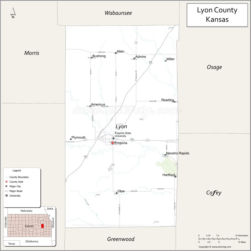
About Lyon County Map, Kansas: The map showing the county boundary, county seat, major cities, highways, water bodies and neighbouring counties.
Related Kansas Links
Map of Lyon County, Kansas
Lyon County is a county located in the U.S. state of Kansas. It's county seat is Emporia. As per 2020 census, the population of Lyon County is 31998 people and population density is square miles. According to the United States Census Bureau, the county has a total area of 851 sq mi (2,204 km2). Lyon County was established on 1855.
Lyon County Facts
| Continent | North America |
| Country | United States |
| State | Kansas |
| County Seat | Emporia |
| Largest City/Town | Emporia |
| Established | 1855 |
| Total Area | 855 sq mi (2,214 sq km) |
| Land Area | 847 sq mi (2,194 sq km) |
| Water Area | 8 sq mi (21 sq km) |
| Population | 32,179 (Census 2020) |
| Population Density | 38 people per sq mi |
| Time Zone | Central Time Zone (CT) |
| Major Highways | I-35, US-50, K-99, K-170 |
| Major Rivers | Neosho River, Cottonwood River |
| Neighboring Counties | Osage County, KS; Morris County, KS; Chase County, KS; Coffey County, KS; Greenwood County, KS; Wabaunsee County, KS |
| Famous For | Emporia State University, Flint Hills, Unbound Gravel cycling event |
| Top Attractions | Flint Hills, David Traylor Zoo, Emporia State University, Peter Pan Park |
| Official Website | Official Website |
About Lyon County, Kansas
Lyon County is located in the east-central part of Kansas, in the state of the United States, and was established in 1855. The county seat is Emporia, which is also the largest city. The county lies within the scenic Flint Hills region and features rolling prairie landscapes, rivers, and a strong educational and cultural presence.
Cities and Towns in Lyon County, Kansas
| City/Town | Population (Census 2020) | Latitude & Longitude |
|---|---|---|
| Emporia (county seat) | 24,139 | 38.4039°N, 96.1817°W |
| Americus | 894 | 38.5061°N, 96.2631°W |
| Hartford | 348 | 38.3006°N, 95.9964°W |
| Neosho Rapids | 248 | 38.3719°N, 95.9958°W |
| Olpe | 546 | 38.2603°N, 96.1697°W |
| Reading | 231 | 38.5192°N, 95.9589°W |
| Admire | 156 | 38.6450°N, 96.1022°W |
| Allen | 177 | 38.6589°N, 96.1700°W |
| Miller | 15 | 38.4581°N, 96.1050°W |
| Plymouth (CDP) | 120 | 38.4100°N, 96.1500°W |
Golf Courses in Lyon County, Kansas
| Golf Course | Location | Latitude & Longitude |
|---|---|---|
| Emporia Golf Course | Emporia | 38.4115°N, 96.1950°W |
| Indian Hills Golf Course | Emporia | 38.4060°N, 96.2100°W |
Roads and Highways in Lyon County, Kansas
The county has strong transportation links connecting it to major cities in Kansas.
- Interstate 35 (I-35) – major north-south corridor connecting Emporia to Kansas City and Wichita
- US-50 – runs east-west linking the county to Dodge City and Kansas City
- K-99 – connects Emporia to northern and southern Kansas regions
- K-170 – provides access to the Flint Hills Scenic Byway
Neighboring Counties of Lyon County
- Wabaunsee County, Kansas (north)
- Osage County, Kansas (northeast)
- Coffey County, Kansas (east)
- Greenwood County, Kansas (south)
- Chase County, Kansas (west)
- Morris County, Kansas (northwest)
Top Attractions in Lyon County, Kansas
The county offers a blend of natural beauty and cultural experiences.
- Flint Hills – rolling prairie landscape known for scenic beauty
- David Traylor Zoo – small zoo featuring native and exotic animals
- Emporia State University – historic campus and cultural center
- Peter Pan Park – popular local park with trails and playgrounds
- Flint Hills Scenic Byway – scenic drive through tallgrass prairie
- Emporia Granada Theatre – historic theater hosting events and performances
- Neosho Riverwalk – scenic walking paths along the river
Distance from Lyon County to Nearby Cities
- Emporia to Wichita – 90 mi (145 km)
- Emporia to Topeka – 60 mi (97 km)
- Emporia to Kansas City – 110 mi (177 km)
- Emporia to Manhattan – 85 mi (137 km)
- Emporia to Lawrence – 75 mi (121 km)
FAQs about Lyon County
Lyon County is located in east-central Kansas in the United States.
The population of Lyon County was 32,179 according to the 2020 Census.
The county is known for Emporia State University, the Flint Hills, and the Unbound Gravel cycling event.
Major highways include Interstate 35, US-50, K-99, and K-170.
Yes, Lyon County has golf courses such as Emporia Golf Course and Indian Hills Golf Course.
- Allen County Map
- Anderson County Map
- Atchison County Map
- Barber County Map
- Barton County Map
- Bourbon County Map
- Brown County Map
- Butler County Map
- Chase County Map
- Chautauqua County Map
- Cherokee County Map
- Cheyenne County Map
- Clark County Map
- Clay County Map
- Cloud County Map
- Coffey County Map
- Comanche County Map
- Cowley County Map
- Crawford County Map
- Decatur County Map
- Dickinson County Map
- Doniphan County Map
- Douglas County Map
- Edwards County Map
- Elk County Map
- Ellis County Map
- Ellsworth County Map
- Finney County Map
- Ford County Map
- Franklin County Map
- Geary County Map
- Gove County Map
- Graham County Map
- Grant County Map
- Gray County Map
- Greeley County Map
- Greenwood County Map
- Hamilton County Map
- Harper County Map
- Harvey County Map
- Haskell County Map
- Hodgeman County Map
- Jackson County Map
- Jefferson County Map
- Jewell County Map
- Johnson County Map
- Kearny County Map
- Kingman County Map
- Kiowa County Map
- Labette County Map
- Lane County Map
- Leavenworth County Map
- Lincoln County Map
- Linn County Map
- Logan County Map
- Lyon County Map
- McPherson County Map
- Marion County Map
- Marshall County Map
- Meade County Map
- Miami County Map
- Mitchell County Map
- Montgomery County Map
- Morris County Map
- Morton County Map
- Nemaha County Map
- Neosho County Map
- Ness County Map
- Norton County Map
- Osage County Map
- Osborne County Map
- Ottawa County Map
- Pawnee County Map
- Phillips County Map
- Pottawatomie County Map
- Pratt County Map
- Rawlins County Map
- Reno County Map
- Republic County Map
- Rice County Map
- Riley County Map
- Rooks County Map
- Rush County Map
- Russell County Map
- Saline County Map
- Scott County Map
- Sedgwick County Map
- Seward County Map
- Shawnee County Map
- Sheridan County Map
- Sherman County Map
- Smith County Map
- Stafford County Map
- Stanton County Map
- Stevens County Map
- Sumner County Map
- Thomas County Map
- Trego County Map
- Wabaunsee County Map
- Wallace County Map
- Washington County Map
- Wichita County Map
- Wilson County Map
- Woodson County Map
- Wyandotte County Map
- Alabama Counties
- Alaska boroughs
- Arizona Counties
- Arkansas Counties
- California County Map
- Colorado Counties
- Connecticut Counties
- Delaware Counties
- Florida County Map
- Georgia County Map
- Hawaii Counties
- Idaho Counties
- Illinois Counties
- Indiana Counties
- Iowa Counties
- Kansas Counties
- Kentucky Counties
- Louisiana Counties
- Maine Counties
- Maryland Counties
- Massachusetts Counties
- Michigan County Map
- Minnesota Counties
- Mississippi Counties
- Missouri Counties
- Montana Counties
- Nebraska Counties
- Nevada Counties
- New York Counties
- New Hampshire Counties
- New Jersey Counties
- New Mexico Counties
- North Carolina Counties
- North Dakota Counties
- Ohio County Map
- Oklahoma Counties
- Oregon Counties
- Pennsylvania Counties
- Rhode Island Counties
- South Carolina Counties
- South Dakota Counties
- Map of Tennessee
- Texas County Map
- Utah Counties
- Vermont Counties
- Virginia Counties
- Washington Counties
- West Virginia Counties
- Wisconsin Counties
- Wyoming Counties