Written and Fact-checked by Whereig Editors | Last Updated: May 05, 2026 | 06:30 ET
Map of Clark County - Clark County is a county located in the U.S. state of Kansas. Clark County Map showing cities, highways, important places and water bodies. Get Where is Clark County located in the map, major cities in Clark county, population, areas, and places of interest.
Map of Clark County, Kansas
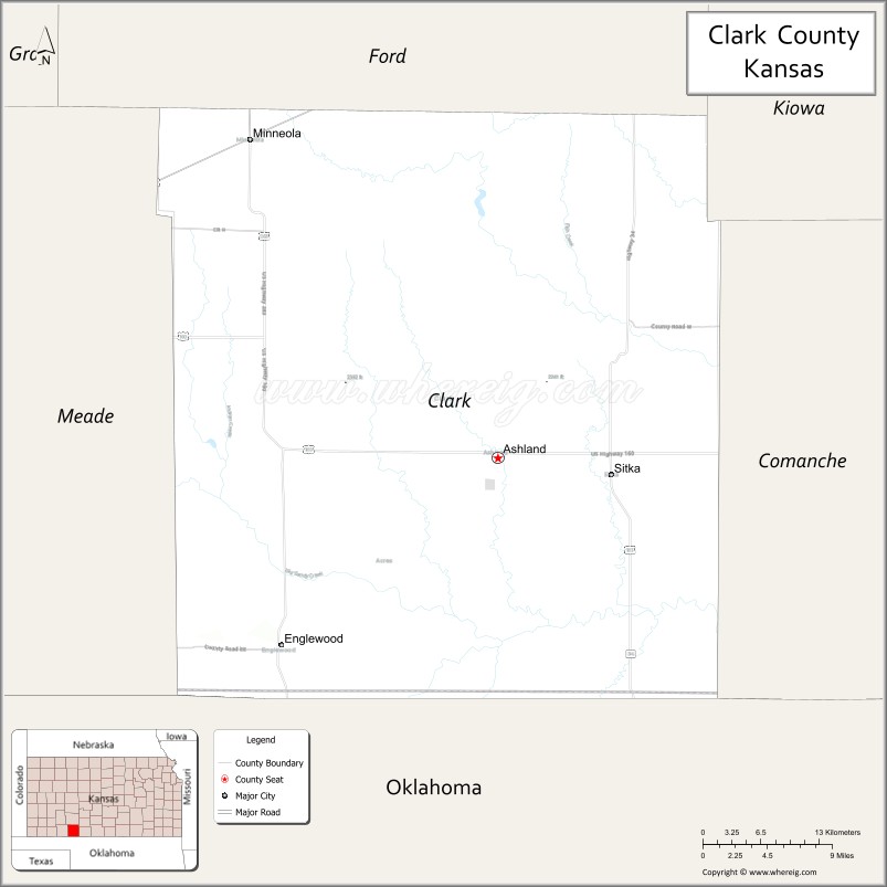
About Clark County Map, Kansas: The map showing the county boundary, county seat, major cities, highways, water bodies and neighbouring counties.
Related Kansas Links
Map of Clark County, Kansas
Clark County is a county located in the U.S. state of Kansas. It's county seat is Ashland. As per 2020 census, the population of Clark County is 1977 people and population density is square miles. According to the United States Census Bureau, the county has a total area of 975 sq mi (2,525 km2). Clark County was established on 1885.
Clark County Facts
| Continent | North America |
| Country | United States |
| State | Kansas |
| County Seat | Ashland |
| Largest City/Town | Ashland |
| Established | 1867 |
| Total Area | 975 sq mi (2,525 sq km) |
| Land Area | 974 sq mi (2,522 sq km) |
| Water Area | 1 sq mi (3 sq km) |
| Population | 1,991 (Census 2020) |
| Population Density | 2 people per sq mi |
| Time Zone | Central Time Zone (CT) |
| Major Highways | US-54, US-160, K-34 |
| Major Rivers | Cimarron River |
| Neighboring Counties | Meade County, Comanche County, Kiowa County, Beaver County (OK), Harper County (OK) |
| Famous For | Clark County State Fishing Lake, High Plains landscapes, ranching |
| Top Attractions | Clark County State Fishing Lake, Ashland Museum, Cimarron National Grassland (nearby), Big Basin Prairie Preserve |
| Official Website | Official Website |
About Clark County, Kansas
Clark County is located in the south-central part of Kansas, in the United States, and was established in 1867. The county seat is Ashland, which is also the largest city. The county lies near the Oklahoma border in the High Plains region and is known for its wide-open landscapes, ranching heritage, and natural attractions such as grasslands and prairie preserves.
Cities and Towns in Clark County, Kansas
| City/Town | Population (Census 2020) | Latitude & Longitude |
|---|---|---|
| Ashland (county seat) | 800+ | 37.1800°N, 99.7600°W |
| Minneola | 700+ | 37.4500°N, 100.0200°W |
| Englewood | 100+ | 37.0500°N, 99.9700°W |
| Protection (nearby in Comanche County) | — | 37.1900°N, 99.4800°W |
Golf Courses in Clark County, Kansas
| Golf Course | Location | Latitude & Longitude |
|---|---|---|
| Clark County Golf Course | Ashland | 37.1800°N, 99.7600°W |
| No other major courses in the county | — | — |
Roads and Highways in Clark County, Kansas
Clark County is connected by highways serving south-central Kansas and the Oklahoma border region.
- US-54 – major east–west route through the county
- US-160 – crosses the southern part of the county
- K-34 – connects local communities within the county
Neighboring Counties of Clark County
- Kiowa County (north)
- Meade County (west)
- Comanche County (east)
- Beaver County, Oklahoma (southwest)
- Harper County, Oklahoma (south)
Top Attractions in Clark County, Kansas
The county offers outdoor recreation, natural areas, and rural scenery.
- Clark County State Fishing Lake – fishing, camping, and wildlife viewing
- Big Basin Prairie Preserve – natural sinkhole and scenic prairie
- Ashland Museum – local history exhibits
- Cimarron National Grassland (nearby) – hiking and wildlife
- Cimarron River – outdoor recreation and nature
- Open prairie landscapes – scenic High Plains views
Distance from Clark County to Nearby Cities
- Ashland to Dodge City – 90 mi (145 km)
- Ashland to Wichita – 150 mi (241 km)
- Ashland to Liberal – 70 mi (113 km)
- Ashland to Oklahoma City, OK – 200 mi (322 km)
- Ashland to Kansas City – 300 mi (483 km)
FAQs about Clark County
Clark County is located in south-central Kansas near the Oklahoma border.
The population of Clark County is 1,991 according to the 2020 Census.
Clark County is known for its High Plains landscapes, ranching, and outdoor recreation areas.
Major highways include US-54, US-160, and K-34.
Yes, Clark County has a golf course such as Clark County Golf Course.
- Allen County Map
- Anderson County Map
- Atchison County Map
- Barber County Map
- Barton County Map
- Bourbon County Map
- Brown County Map
- Butler County Map
- Chase County Map
- Chautauqua County Map
- Cherokee County Map
- Cheyenne County Map
- Clark County Map
- Clay County Map
- Cloud County Map
- Coffey County Map
- Comanche County Map
- Cowley County Map
- Crawford County Map
- Decatur County Map
- Dickinson County Map
- Doniphan County Map
- Douglas County Map
- Edwards County Map
- Elk County Map
- Ellis County Map
- Ellsworth County Map
- Finney County Map
- Ford County Map
- Franklin County Map
- Geary County Map
- Gove County Map
- Graham County Map
- Grant County Map
- Gray County Map
- Greeley County Map
- Greenwood County Map
- Hamilton County Map
- Harper County Map
- Harvey County Map
- Haskell County Map
- Hodgeman County Map
- Jackson County Map
- Jefferson County Map
- Jewell County Map
- Johnson County Map
- Kearny County Map
- Kingman County Map
- Kiowa County Map
- Labette County Map
- Lane County Map
- Leavenworth County Map
- Lincoln County Map
- Linn County Map
- Logan County Map
- Lyon County Map
- McPherson County Map
- Marion County Map
- Marshall County Map
- Meade County Map
- Miami County Map
- Mitchell County Map
- Montgomery County Map
- Morris County Map
- Morton County Map
- Nemaha County Map
- Neosho County Map
- Ness County Map
- Norton County Map
- Osage County Map
- Osborne County Map
- Ottawa County Map
- Pawnee County Map
- Phillips County Map
- Pottawatomie County Map
- Pratt County Map
- Rawlins County Map
- Reno County Map
- Republic County Map
- Rice County Map
- Riley County Map
- Rooks County Map
- Rush County Map
- Russell County Map
- Saline County Map
- Scott County Map
- Sedgwick County Map
- Seward County Map
- Shawnee County Map
- Sheridan County Map
- Sherman County Map
- Smith County Map
- Stafford County Map
- Stanton County Map
- Stevens County Map
- Sumner County Map
- Thomas County Map
- Trego County Map
- Wabaunsee County Map
- Wallace County Map
- Washington County Map
- Wichita County Map
- Wilson County Map
- Woodson County Map
- Wyandotte County Map
- Alabama Counties
- Alaska boroughs
- Arizona Counties
- Arkansas Counties
- California County Map
- Colorado Counties
- Connecticut Counties
- Delaware Counties
- Florida County Map
- Georgia County Map
- Hawaii Counties
- Idaho Counties
- Illinois Counties
- Indiana Counties
- Iowa Counties
- Kansas Counties
- Kentucky Counties
- Louisiana Counties
- Maine Counties
- Maryland Counties
- Massachusetts Counties
- Michigan County Map
- Minnesota Counties
- Mississippi Counties
- Missouri Counties
- Montana Counties
- Nebraska Counties
- Nevada Counties
- New York Counties
- New Hampshire Counties
- New Jersey Counties
- New Mexico Counties
- North Carolina Counties
- North Dakota Counties
- Ohio County Map
- Oklahoma Counties
- Oregon Counties
- Pennsylvania Counties
- Rhode Island Counties
- South Carolina Counties
- South Dakota Counties
- Map of Tennessee
- Texas County Map
- Utah Counties
- Vermont Counties
- Virginia Counties
- Washington Counties
- West Virginia Counties
- Wisconsin Counties
- Wyoming Counties