Written and Fact-checked by Whereig Editors | Last Updated: May 05, 2026 | 06:30 ET
Map of Wyandotte County - Wyandotte County is a county located in the U.S. state of Kansas. Wyandotte County Map showing cities, highways, important places and water bodies. Get Where is Wyandotte County located in the map, major cities in Wyandotte county, population, areas, and places of interest.
Map of Wyandotte County, Kansas
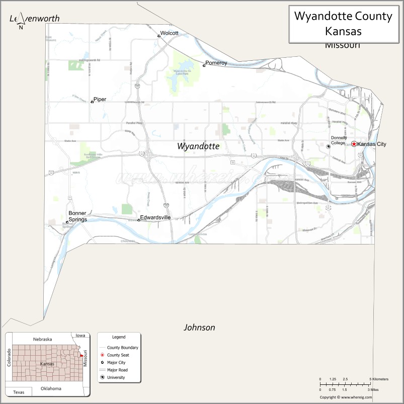
About Wyandotte County Map, Kansas: The map showing the county boundary, county seat, major cities, highways, water bodies and neighbouring counties.
Related Kansas Links
Map of Wyandotte County, Kansas
Wyandotte County is a county located in the U.S. state of Kansas. It's county seat is Kansas City. As per 2020 census, the population of Wyandotte County is 167046 people and population density is square miles. According to the United States Census Bureau, the county has a total area of 151 sq mi (391 km2). Wyandotte County was established on 1859.
Wyandotte County Facts
| Continent | North America |
| Country | United States |
| State | Kansas |
| County Seat | Kansas City |
| Largest City/Town | Kansas City |
| Established | 1859 |
| Total Area | 156 sq mi (404 sq km) |
| Land Area | 152 sq mi (394 sq km) |
| Water Area | 4 sq mi (10 sq km) |
| Population | 169,245 (Census 2020) |
| Population Density | 1,114 people per sq mi |
| Time Zone | Central Time Zone (CT) |
| Major Highways | I-70, I-35, I-635, US-69, US-24, US-73 |
| Major Rivers | Kansas River (Kaw River), Missouri River |
| Neighboring Counties | Leavenworth County, KS; Johnson County, KS; Platte County, MO; Clay County, MO; Jackson County, MO |
| Famous For | Kansas Speedway, urban development, Kansas City metropolitan area |
| Top Attractions | Kansas Speedway, Legends Outlets, Sporting Park, Schlitterbahn Waterpark (historic site) |
| Official Website | Official Website |
About Wyandotte County, Kansas
Wyandotte County is located in the northeastern part of Kansas, in the state of the United States, and was established in 1859. The county seat is Kansas City, which is also the largest city. The county forms part of the Kansas City metropolitan area and is known for its urban environment, cultural attractions, and economic activity.
Cities and Towns in Wyandotte County, Kansas
| City/Town | Population (Census 2020) | Latitude & Longitude |
|---|---|---|
| Kansas City (county seat) | 156,607 | 39.1141°N, 94.6275°W |
| Bonner Springs | 7,837 | 39.0597°N, 94.8830°W |
| Edwardsville | 4,717 | 39.0606°N, 94.8840°W |
Golf Courses in Wyandotte County, Kansas
| Golf Course | Location | Latitude & Longitude |
|---|---|---|
| Sunflower Hills Golf Course | Bonner Springs | 39.0615°N, 94.8855°W |
| Dub's Dread Golf Club | Kansas City | 39.1165°N, 94.6295°W |
Roads and Highways in Wyandotte County, Kansas
The county is a major transportation hub within the Kansas City metropolitan area.
- Interstate 70 (I-70) – major east-west corridor connecting Denver to St. Louis
- Interstate 35 (I-35) – north-south route connecting the county to Des Moines and Oklahoma City
- Interstate 635 (I-635) – loop providing access across the metropolitan area
- US-69, US-24, and US-73 – provide additional regional connectivity
Neighboring Counties of Wyandotte County
- Leavenworth County, Kansas (northwest)
- Johnson County, Kansas (south)
- Platte County, Missouri (north)
- Clay County, Missouri (northeast)
- Jackson County, Missouri (east)
Top Attractions in Wyandotte County, Kansas
The county offers major entertainment, sports, and shopping attractions.
- Kansas Speedway – major motorsports venue
- Legends Outlets Kansas City – large outdoor shopping and entertainment complex
- Children’s Mercy Park – home stadium of Sporting Kansas City soccer team
- Kaw Point Park – scenic park at the confluence of the Kansas and Missouri Rivers
- Wyandotte County Lake Park – recreational area with trails and water activities
- Strawberry Hill Museum – cultural and historical exhibits
- Downtown Kansas City, KS – vibrant area with dining and local attractions
Distance from Wyandotte County to Nearby Cities
- Kansas City, KS to Kansas City, MO – 5 mi (8 km)
- Kansas City, KS to Topeka – 60 mi (97 km)
- Kansas City, KS to Wichita – 190 mi (306 km)
- Kansas City, KS to Omaha – 190 mi (306 km)
- Kansas City, KS to St. Louis – 250 mi (402 km)
FAQs about Wyandotte County
Wyandotte County is located in northeastern Kansas within the Kansas City metropolitan area in the United States.
The population of Wyandotte County was 169,245 according to the 2020 Census.
The county is known for Kansas Speedway, urban development, and its role in the Kansas City metro area.
Major highways include I-70, I-35, I-635, US-69, US-24, and US-73.
Yes, Wyandotte County has golf courses such as Sunflower Hills Golf Course and Dub's Dread Golf Club.
- Allen County Map
- Anderson County Map
- Atchison County Map
- Barber County Map
- Barton County Map
- Bourbon County Map
- Brown County Map
- Butler County Map
- Chase County Map
- Chautauqua County Map
- Cherokee County Map
- Cheyenne County Map
- Clark County Map
- Clay County Map
- Cloud County Map
- Coffey County Map
- Comanche County Map
- Cowley County Map
- Crawford County Map
- Decatur County Map
- Dickinson County Map
- Doniphan County Map
- Douglas County Map
- Edwards County Map
- Elk County Map
- Ellis County Map
- Ellsworth County Map
- Finney County Map
- Ford County Map
- Franklin County Map
- Geary County Map
- Gove County Map
- Graham County Map
- Grant County Map
- Gray County Map
- Greeley County Map
- Greenwood County Map
- Hamilton County Map
- Harper County Map
- Harvey County Map
- Haskell County Map
- Hodgeman County Map
- Jackson County Map
- Jefferson County Map
- Jewell County Map
- Johnson County Map
- Kearny County Map
- Kingman County Map
- Kiowa County Map
- Labette County Map
- Lane County Map
- Leavenworth County Map
- Lincoln County Map
- Linn County Map
- Logan County Map
- Lyon County Map
- McPherson County Map
- Marion County Map
- Marshall County Map
- Meade County Map
- Miami County Map
- Mitchell County Map
- Montgomery County Map
- Morris County Map
- Morton County Map
- Nemaha County Map
- Neosho County Map
- Ness County Map
- Norton County Map
- Osage County Map
- Osborne County Map
- Ottawa County Map
- Pawnee County Map
- Phillips County Map
- Pottawatomie County Map
- Pratt County Map
- Rawlins County Map
- Reno County Map
- Republic County Map
- Rice County Map
- Riley County Map
- Rooks County Map
- Rush County Map
- Russell County Map
- Saline County Map
- Scott County Map
- Sedgwick County Map
- Seward County Map
- Shawnee County Map
- Sheridan County Map
- Sherman County Map
- Smith County Map
- Stafford County Map
- Stanton County Map
- Stevens County Map
- Sumner County Map
- Thomas County Map
- Trego County Map
- Wabaunsee County Map
- Wallace County Map
- Washington County Map
- Wichita County Map
- Wilson County Map
- Woodson County Map
- Wyandotte County Map
- Alabama Counties
- Alaska boroughs
- Arizona Counties
- Arkansas Counties
- California County Map
- Colorado Counties
- Connecticut Counties
- Delaware Counties
- Florida County Map
- Georgia County Map
- Hawaii Counties
- Idaho Counties
- Illinois Counties
- Indiana Counties
- Iowa Counties
- Kansas Counties
- Kentucky Counties
- Louisiana Counties
- Maine Counties
- Maryland Counties
- Massachusetts Counties
- Michigan County Map
- Minnesota Counties
- Mississippi Counties
- Missouri Counties
- Montana Counties
- Nebraska Counties
- Nevada Counties
- New York Counties
- New Hampshire Counties
- New Jersey Counties
- New Mexico Counties
- North Carolina Counties
- North Dakota Counties
- Ohio County Map
- Oklahoma Counties
- Oregon Counties
- Pennsylvania Counties
- Rhode Island Counties
- South Carolina Counties
- South Dakota Counties
- Map of Tennessee
- Texas County Map
- Utah Counties
- Vermont Counties
- Virginia Counties
- Washington Counties
- West Virginia Counties
- Wisconsin Counties
- Wyoming Counties