Written and Fact-checked by Whereig Editors | Last Updated: May 05, 2026 | 06:30 ET
Map of Johnson County - Johnson County is a county located in the U.S. state of Kansas. Johnson County Map showing cities, highways, important places and water bodies. Get Where is Johnson County located in the map, major cities in Johnson county, population, areas, and places of interest.
Map of Johnson County, Kansas
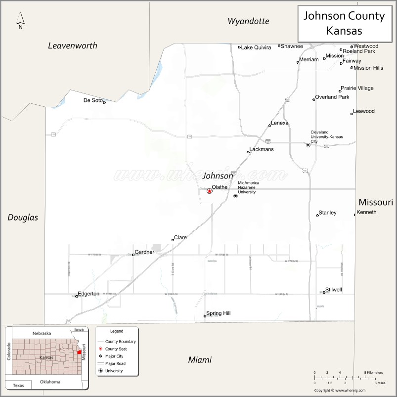
About Johnson County Map, Kansas: The map showing the county boundary, county seat, major cities, highways, water bodies and neighbouring counties.
Related Kansas Links
Map of Johnson County, Kansas
Johnson County is a county located in the U.S. state of Kansas. It's county seat is Olathe. As per 2020 census, the population of Johnson County is 613219 people and population density is square miles. According to the United States Census Bureau, the county has a total area of 477 sq mi (1,235 km2). Johnson County was established on 1855.
Johnson County Facts
| Continent | North America |
| Country | United States |
| State | Kansas |
| County Seat | Olathe |
| Largest City/Town | Overland Park |
| Established | 1855 |
| Total Area | 480 sq mi (1,243 sq km) |
| Land Area | 473 sq mi (1,225 sq km) |
| Water Area | 7 sq mi (18 sq km) |
| Population | 609,863 (Census 2020) |
| Population Density | 1,290 people per sq mi |
| Time Zone | Central Time Zone (CT) |
| Major Highways | I-35, I-435, I-635, US-69, US-56, K-7, K-10 |
| Major Rivers | Kansas River (Kaw River), Blue River |
| Neighboring Counties | Leavenworth County, Wyandotte County, Douglas County, Miami County |
| Famous For | Kansas City metropolitan area, business hubs, suburban communities |
| Top Attractions | Overland Park Arboretum & Botanical Gardens, Deanna Rose Children's Farmstead, Museum at Prairiefire, Shawnee Mission Park |
| Official Website | Official Website |
About Johnson County, Kansas
Johnson County is located in the northeastern part of Kansas, in the United States, and was established in 1855. The county seat is Olathe, while Overland Park is the largest city. The county lies along the Kansas River and is part of the Kansas City metropolitan area, known for its strong economy, suburban communities, and high quality of life.
Cities and Towns in Johnson County, Kansas
| City/Town | Population (Census 2020) | Latitude & Longitude |
|---|---|---|
| Overland Park | 197,000+ | 38.9800°N, 94.6700°W |
| Olathe (county seat) | 141,000+ | 38.8800°N, 94.8200°W |
| Shawnee | 67,000+ | 39.0200°N, 94.7200°W |
| Lenexa | 57,000+ | 38.9500°N, 94.7400°W |
| Leawood | 33,000+ | 38.9600°N, 94.6200°W |
| Prairie Village | 22,000+ | 38.9900°N, 94.6300°W |
| Gardner | 23,000+ | 38.8100°N, 94.9300°W |
| Mission | 9,500+ | 39.0200°N, 94.6500°W |
| Roeland Park | 7,500+ | 39.0000°N, 94.6600°W |
| Fairway | 4,200+ | 39.0300°N, 94.6400°W |
| Westwood | 1,700+ | 39.0400°N, 94.6300°W |
| Westwood Hills | 400+ | 39.0400°N, 94.6400°W |
| Lake Quivira (partly in county) | 1,000+ | 39.0500°N, 94.7700°W |
Golf Courses in Johnson County, Kansas
| Golf Course | Location | Latitude & Longitude |
|---|---|---|
| Falcon Ridge Golf Club | Lenexa | 38.9500°N, 94.7400°W |
| St. Andrews Golf Club | Overland Park | 38.9800°N, 94.6700°W |
| Sycamore Ridge Golf Club | Spring Hill | 38.7400°N, 94.8300°W |
| Tomahawk Hills Golf Course | Shawnee | 39.0200°N, 94.7200°W |
Roads and Highways in Johnson County, Kansas
Johnson County is a major transportation hub in the Kansas City metro area.
- I-35 – major north–south interstate connecting Kansas City and Wichita
- I-435 – beltway around the Kansas City metro area
- I-635 – connector route in the metro region
- US-69 – key north–south route through suburban areas
- US-56 – east–west highway
- K-7 and K-10 – important regional routes
Neighboring Counties of Johnson County
- Leavenworth County (north)
- Wyandotte County (north and east)
- Douglas County (west)
- Miami County (south)
Top Attractions in Johnson County, Kansas
The county offers parks, cultural attractions, and family-friendly destinations.
- Overland Park Arboretum & Botanical Gardens – scenic gardens and trails
- Deanna Rose Children's Farmstead – interactive farm attraction
- Museum at Prairiefire – natural history and science exhibits
- Shawnee Mission Park – large park with lake and trails
- Ernie Miller Nature Center – wildlife and educational programs
- Downtown Overland Park – shopping, dining, and events
Distance from Johnson County to Nearby Cities
- Olathe to Kansas City – 20 mi (32 km)
- Olathe to Lawrence – 30 mi (48 km)
- Olathe to Topeka – 60 mi (97 km)
- Olathe to Wichita – 190 mi (306 km)
- Olathe to Omaha, NE – 190 mi (306 km)
FAQs about Johnson County
Johnson County is located in northeastern Kansas as part of the Kansas City metropolitan area.
The population of Johnson County is 609,863 according to the 2020 Census.
Johnson County is known for its suburban communities, strong economy, and its role in the Kansas City metro area.
Major highways include I-35, I-435, I-635, US-69, US-56, K-7, and K-10.
Yes, Johnson County has several golf courses including Falcon Ridge Golf Club, St. Andrews Golf Club, Sycamore Ridge Golf Club, and Tomahawk Hills Golf Course.
- Allen County Map
- Anderson County Map
- Atchison County Map
- Barber County Map
- Barton County Map
- Bourbon County Map
- Brown County Map
- Butler County Map
- Chase County Map
- Chautauqua County Map
- Cherokee County Map
- Cheyenne County Map
- Clark County Map
- Clay County Map
- Cloud County Map
- Coffey County Map
- Comanche County Map
- Cowley County Map
- Crawford County Map
- Decatur County Map
- Dickinson County Map
- Doniphan County Map
- Douglas County Map
- Edwards County Map
- Elk County Map
- Ellis County Map
- Ellsworth County Map
- Finney County Map
- Ford County Map
- Franklin County Map
- Geary County Map
- Gove County Map
- Graham County Map
- Grant County Map
- Gray County Map
- Greeley County Map
- Greenwood County Map
- Hamilton County Map
- Harper County Map
- Harvey County Map
- Haskell County Map
- Hodgeman County Map
- Jackson County Map
- Jefferson County Map
- Jewell County Map
- Johnson County Map
- Kearny County Map
- Kingman County Map
- Kiowa County Map
- Labette County Map
- Lane County Map
- Leavenworth County Map
- Lincoln County Map
- Linn County Map
- Logan County Map
- Lyon County Map
- McPherson County Map
- Marion County Map
- Marshall County Map
- Meade County Map
- Miami County Map
- Mitchell County Map
- Montgomery County Map
- Morris County Map
- Morton County Map
- Nemaha County Map
- Neosho County Map
- Ness County Map
- Norton County Map
- Osage County Map
- Osborne County Map
- Ottawa County Map
- Pawnee County Map
- Phillips County Map
- Pottawatomie County Map
- Pratt County Map
- Rawlins County Map
- Reno County Map
- Republic County Map
- Rice County Map
- Riley County Map
- Rooks County Map
- Rush County Map
- Russell County Map
- Saline County Map
- Scott County Map
- Sedgwick County Map
- Seward County Map
- Shawnee County Map
- Sheridan County Map
- Sherman County Map
- Smith County Map
- Stafford County Map
- Stanton County Map
- Stevens County Map
- Sumner County Map
- Thomas County Map
- Trego County Map
- Wabaunsee County Map
- Wallace County Map
- Washington County Map
- Wichita County Map
- Wilson County Map
- Woodson County Map
- Wyandotte County Map
- Alabama Counties
- Alaska boroughs
- Arizona Counties
- Arkansas Counties
- California County Map
- Colorado Counties
- Connecticut Counties
- Delaware Counties
- Florida County Map
- Georgia County Map
- Hawaii Counties
- Idaho Counties
- Illinois Counties
- Indiana Counties
- Iowa Counties
- Kansas Counties
- Kentucky Counties
- Louisiana Counties
- Maine Counties
- Maryland Counties
- Massachusetts Counties
- Michigan County Map
- Minnesota Counties
- Mississippi Counties
- Missouri Counties
- Montana Counties
- Nebraska Counties
- Nevada Counties
- New York Counties
- New Hampshire Counties
- New Jersey Counties
- New Mexico Counties
- North Carolina Counties
- North Dakota Counties
- Ohio County Map
- Oklahoma Counties
- Oregon Counties
- Pennsylvania Counties
- Rhode Island Counties
- South Carolina Counties
- South Dakota Counties
- Map of Tennessee
- Texas County Map
- Utah Counties
- Vermont Counties
- Virginia Counties
- Washington Counties
- West Virginia Counties
- Wisconsin Counties
- Wyoming Counties