Written and Fact-checked by Whereig Editors | Last Updated: May 05, 2026 | 06:30 ET
Map of Kiowa County - Kiowa County is a county located in the U.S. state of Kansas. Kiowa County Map showing cities, highways, important places and water bodies. Get Where is Kiowa County located in the map, major cities in Kiowa county, population, areas, and places of interest.
Map of Kiowa County, Kansas
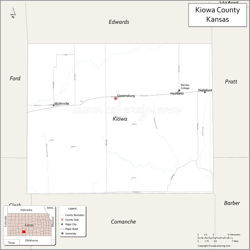
About Kiowa County Map, Kansas: The map showing the county boundary, county seat, major cities, highways, water bodies and neighbouring counties.
Related Kansas Links
Map of Kiowa County, Kansas
Kiowa County is a county located in the U.S. state of Kansas. It's county seat is Greensburg. As per 2020 census, the population of Kiowa County is 2392 people and population density is square miles. According to the United States Census Bureau, the county has a total area of 722 sq mi (1,870 km2). Kiowa County was established on 1886.
Kiowa County Facts
| Continent | North America |
| Country | United States |
| State | Kansas |
| County Seat | Greensburg |
| Largest City/Town | Greensburg |
| Established | 1872 |
| Total Area | 723 sq mi (1,873 sq km) |
| Land Area | 723 sq mi (1,873 sq km) |
| Water Area | 0.1 sq mi (0.3 sq km) |
| Population | 2,460 (Census 2020) |
| Population Density | 3 people per sq mi |
| Time Zone | Central Time Zone (CT) |
| Major Highways | US-54, US-400, K-23, K-98 |
| Major Rivers | Medicine Lodge River |
| Neighboring Counties | Edwards County, KS; Pratt County, KS; Comanche County, KS; Clark County, KS; Ford County, KS |
| Famous For | Greensburg green rebuilding, wind energy, Big Well |
| Top Attractions | Big Well Museum, Greensburg Wind Farm, Kiowa County State Lake, Twilight Theatre |
| Official Website | Official Website |
About Kiowa County, Kansas
Kiowa County is located in the south-central part of Kansas, in the state of the United States, and was established in 1872. The county seat is Greensburg, which is also the largest city. The county is known for its flat plains, agricultural lands, and its nationally recognized rebuilding efforts after a major tornado in 2007.
Cities and Towns in Kiowa County, Kansas
| City/Town | Population (Census 2020) | Latitude & Longitude |
|---|---|---|
| Greensburg (county seat) | 740 | 37.6070°N, 99.2954°W |
| Haviland | 678 | 37.6192°N, 99.1081°W |
| Mullinville | 255 | 37.5831°N, 99.4740°W |
| Belvidere | 48 | 37.4458°N, 99.0834°W |
Golf Courses in Kiowa County, Kansas
| Golf Course | Location | Latitude & Longitude |
|---|---|---|
| Greensburg Country Club | Greensburg | 37.6042°N, 99.2987°W |
Roads and Highways in Kiowa County, Kansas
The county is served by major highways that provide regional connectivity across Kansas.
- US-54 – runs east-west connecting Greensburg to Pratt and Dodge City
- US-400 – overlaps with US-54 as a major regional corridor
- K-23 – north-south route connecting the county to western Kansas regions
- K-98 – links smaller communities within the county
Neighboring Counties of Kiowa County
- Edwards County, Kansas (north)
- Pratt County, Kansas (east)
- Comanche County, Kansas (south)
- Clark County, Kansas (southwest)
- Ford County, Kansas (west)
Top Attractions in Kiowa County, Kansas
The county features unique attractions tied to history and resilience.
- Big Well Museum – home to the world’s largest hand-dug well
- Greensburg Wind Farm – large-scale wind energy project visible across the plains
- Kiowa County State Lake – quiet spot for fishing, camping, and outdoor relaxation
- Twilight Theatre – restored historic theater in downtown Greensburg
- Greensburg GreenTown – showcases sustainable rebuilding efforts after the 2007 tornado
- Mullinville Murals – roadside folk art displays and sculptures
Distance from Kiowa County to Nearby Cities
- Greensburg to Pratt – 35 mi (56 km)
- Greensburg to Dodge City – 55 mi (89 km)
- Greensburg to Wichita – 110 mi (177 km)
- Greensburg to Liberal – 140 mi (225 km)
- Greensburg to Kansas City – 330 mi (531 km)
FAQs about Kiowa County
Kiowa County is located in south-central Kansas in the United States.
The population of Kiowa County was 2,460 according to the 2020 Census.
The county is known for Greensburg’s green rebuilding after the 2007 tornado, wind energy projects, and the Big Well Museum.
Major highways include US-54, US-400, K-23, and K-98.
Yes, Kiowa County has a golf course known as Greensburg Country Club located in Greensburg.
- Allen County Map
- Anderson County Map
- Atchison County Map
- Barber County Map
- Barton County Map
- Bourbon County Map
- Brown County Map
- Butler County Map
- Chase County Map
- Chautauqua County Map
- Cherokee County Map
- Cheyenne County Map
- Clark County Map
- Clay County Map
- Cloud County Map
- Coffey County Map
- Comanche County Map
- Cowley County Map
- Crawford County Map
- Decatur County Map
- Dickinson County Map
- Doniphan County Map
- Douglas County Map
- Edwards County Map
- Elk County Map
- Ellis County Map
- Ellsworth County Map
- Finney County Map
- Ford County Map
- Franklin County Map
- Geary County Map
- Gove County Map
- Graham County Map
- Grant County Map
- Gray County Map
- Greeley County Map
- Greenwood County Map
- Hamilton County Map
- Harper County Map
- Harvey County Map
- Haskell County Map
- Hodgeman County Map
- Jackson County Map
- Jefferson County Map
- Jewell County Map
- Johnson County Map
- Kearny County Map
- Kingman County Map
- Kiowa County Map
- Labette County Map
- Lane County Map
- Leavenworth County Map
- Lincoln County Map
- Linn County Map
- Logan County Map
- Lyon County Map
- McPherson County Map
- Marion County Map
- Marshall County Map
- Meade County Map
- Miami County Map
- Mitchell County Map
- Montgomery County Map
- Morris County Map
- Morton County Map
- Nemaha County Map
- Neosho County Map
- Ness County Map
- Norton County Map
- Osage County Map
- Osborne County Map
- Ottawa County Map
- Pawnee County Map
- Phillips County Map
- Pottawatomie County Map
- Pratt County Map
- Rawlins County Map
- Reno County Map
- Republic County Map
- Rice County Map
- Riley County Map
- Rooks County Map
- Rush County Map
- Russell County Map
- Saline County Map
- Scott County Map
- Sedgwick County Map
- Seward County Map
- Shawnee County Map
- Sheridan County Map
- Sherman County Map
- Smith County Map
- Stafford County Map
- Stanton County Map
- Stevens County Map
- Sumner County Map
- Thomas County Map
- Trego County Map
- Wabaunsee County Map
- Wallace County Map
- Washington County Map
- Wichita County Map
- Wilson County Map
- Woodson County Map
- Wyandotte County Map
- Alabama Counties
- Alaska boroughs
- Arizona Counties
- Arkansas Counties
- California County Map
- Colorado Counties
- Connecticut Counties
- Delaware Counties
- Florida County Map
- Georgia County Map
- Hawaii Counties
- Idaho Counties
- Illinois Counties
- Indiana Counties
- Iowa Counties
- Kansas Counties
- Kentucky Counties
- Louisiana Counties
- Maine Counties
- Maryland Counties
- Massachusetts Counties
- Michigan County Map
- Minnesota Counties
- Mississippi Counties
- Missouri Counties
- Montana Counties
- Nebraska Counties
- Nevada Counties
- New York Counties
- New Hampshire Counties
- New Jersey Counties
- New Mexico Counties
- North Carolina Counties
- North Dakota Counties
- Ohio County Map
- Oklahoma Counties
- Oregon Counties
- Pennsylvania Counties
- Rhode Island Counties
- South Carolina Counties
- South Dakota Counties
- Map of Tennessee
- Texas County Map
- Utah Counties
- Vermont Counties
- Virginia Counties
- Washington Counties
- West Virginia Counties
- Wisconsin Counties
- Wyoming Counties