Map of Dukes County - Dukes County is a county located in the U.S. state of Massachusetts. Dukes County Map showing cities, highways, important places and water bodies. Get Where is Dukes County located in the map, major cities in Dukes county, population, areas, and places of interest.
Map of Dukes County, Massachusetts
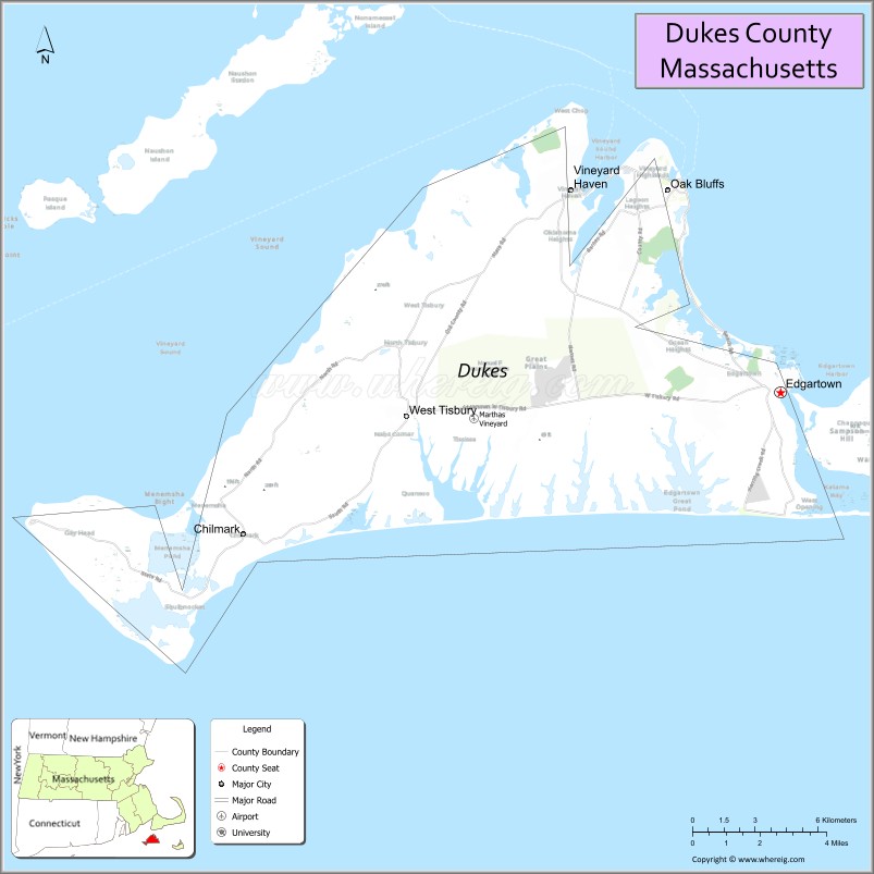
About Dukes County Map, Massachusetts: The map showing the county boundary, county seat, major cities, highways, water bodies and neighbouring counties.
Other Massachusetts Maps & Info
Map of Dukes County, Massachusetts
Dukes County is a county located in the U.S. state of Massachusetts. It's county seat is Edgartown. As per 2020 census, the population of Dukes County is 21097 people and population density is square miles. According to the United States Census Bureau, the county has a total area of 104 sq mi (269 km2). Dukes County was established on 1695.
Dukes County Facts
| Continent | North America |
| Country | United States |
| State | Massachusetts |
| County Seat | Edgartown |
| Largest City/Town | Edgartown |
| Established | 1695 |
| Total Area | 491 sq mi |
| Land Area | 104 sq mi |
| Water Area | 387 sq mi |
| Population | 20,600 (Census 2020) |
| Population Density | 198 people per sq mi |
| Time Zone | Eastern Time Zone (ET) |
| Major Highways | MA-28 (ferry access routes) |
| Neighboring Counties | Barnstable County, Nantucket County |
| Famous For | Martha’s Vineyard, beaches, coastal villages, tourism |
| Top Attractions | Martha’s Vineyard, Edgartown Lighthouse, Aquinnah Cliffs, Oak Bluffs |
| Official Website | https://www.dukescounty.org |
Ctities in Dukes county
| City Name | Type | Population (2020) | Pop. Density | Area | Incorporated |
|---|---|---|---|---|---|
| Aquinnah | Town | 439 | 40.8 sq mi (105.67 km2) sq mi | 1870 | |
| Chilmark | Town | 1,212 | 100.4 sq mi (260.03 km2) sq mi | 1714 | |
| Gosnold | Town | 70 | 140.2 sq mi (363.12 km2) sq mi | 1864 | |
| Oak Bluffs | Town | 5,341 | 26.0 sq mi (67.34 km2) sq mi | 1880 | |
| Tisbury | Town | 4,815 | 19.1 sq mi (49.47 km2) sq mi | 1671 | |
| West Tisbury | Town | 3,555 | 41.8 sq mi (108.26 km2) sq mi | 1892 | |
| Edgartown | Town | 5,168 | 122.7 sq mi (317.79 km2) sq mi | 1671 |
Roads and Highways in Dukes County, Massachusetts
Dukes County has limited highways due to its island geography, with local roads and ferry routes connecting communities.
- Massachusetts Route 28 – connects mainland Massachusetts to ferry terminals serving Martha’s Vineyard
- Local island roads – connect Edgartown, Oak Bluffs, Vineyard Haven, and other towns across Martha’s Vineyard
Neighboring Counties of Dukes County
- Barnstable County (north, across water)
- Nantucket County (east, across water)
Top Attractions in Dukes County, Massachusetts
Dukes County is a popular coastal destination known for its scenic beauty, beaches, and relaxed island lifestyle.
- Martha’s Vineyard – famous island destination with beaches, shops, and coastal views
- Edgartown Lighthouse – historic lighthouse overlooking Edgartown Harbor
- Aquinnah Cliffs – colorful clay cliffs with stunning ocean views
- Oak Bluffs Gingerbread Cottages – charming and colorful historic homes
- Joseph Sylvia State Beach – popular beach for swimming and scenic walks
- Menemsha Harbor – peaceful fishing village known for sunsets
- Gay Head Lighthouse – historic lighthouse near the Aquinnah Cliffs
Distance from Dukes County to Nearby Cities
- Edgartown to Boston – 90 mi (145 km)
- Edgartown to New Bedford – 35 mi (56 km)
- Edgartown to Providence – 70 mi (113 km)
- Edgartown to Hyannis – 30 mi (48 km)
- Edgartown to Hartford – 120 mi (193 km)
FAQs about Dukes County
Dukes County is located in southeastern Massachusetts and includes Martha’s Vineyard and nearby islands.
It is known for Martha’s Vineyard, beautiful beaches, and popular summer tourism.
Edgartown is the largest town and serves as the county seat.
You can reach the county by ferry or small aircraft, as it is made up of islands.
No major interstate highways exist, but local roads connect the towns on Martha’s Vineyard.
- Alabama Counties
- Alaska boroughs
- Arizona Counties
- Arkansas Counties
- California County Map
- Colorado Counties
- Connecticut Counties
- Delaware Counties
- Florida County Map
- Georgia County Map
- Hawaii Counties
- Idaho Counties
- Illinois Counties
- Indiana Counties
- Iowa Counties
- Kansas Counties
- Kentucky Counties
- Louisiana Counties
- Maine Counties
- Maryland Counties
- Massachusetts Counties
- Michigan County Map
- Minnesota Counties
- Mississippi Counties
- Missouri Counties
- Montana Counties
- Nebraska Counties
- Nevada Counties
- New York Counties
- New Hampshire Counties
- New Jersey Counties
- New Mexico Counties
- North Carolina Counties
- North Dakota Counties
- Ohio County Map
- Oklahoma Counties
- Oregon Counties
- Pennsylvania Counties
- Rhode Island Counties
- South Carolina Counties
- South Dakota Counties
- Map of Tennessee
- Texas County Map
- Utah Counties
- Vermont Counties
- Virginia Counties
- Washington Counties
- West Virginia Counties
- Wisconsin Counties
- Wyoming Counties
Written and fact-checked by Whereig.com Web Team | Last Updated: January 27, 2025, 12:15 PM ET