Map of Barnstable County - Barnstable County is a county located in the U.S. state of Massachusetts. Barnstable County Map showing cities, highways, important places and water bodies. Get Where is Barnstable County located in the map, major cities in Barnstable county, population, areas, and places of interest.
Map of Barnstable County, Massachusetts
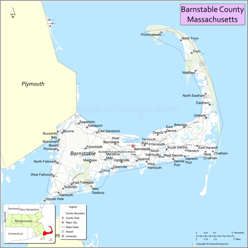
About Barnstable County Map, Massachusetts: The map showing the county boundary, county seat, major cities, highways, water bodies and neighbouring counties.
Other Massachusetts Maps & Info
Map of Barnstable County, Massachusetts
Barnstable County is a county located in the U.S. state of Massachusetts. It's county seat is Barnstable. As per 2020 census, the population of Barnstable County is 232411 people and population density is square miles. According to the United States Census Bureau, the county has a total area of 396 sq mi (1,026 km2). Barnstable County was established on 1685.
Barnstable County Facts
| Continent | North America |
| Country | United States |
| State | Massachusetts |
| County Seat | Barnstable |
| Largest City/Town | Barnstable |
| Established | 1685 |
| Total Area | 1,306 sq mi |
| Land Area | 394 sq mi |
| Water Area | 912 sq mi |
| Population | 228,996 (Census 2020) |
| Population Density | 581 people per sq mi |
| Time Zone | Eastern Time Zone (ET) |
| Major Highways | US-6, MA-3, MA-6A, MA-28 |
| Neighboring Counties | Dukes County, Nantucket County, Plymouth County |
| Famous For | Cape Cod beaches, tourism, fishing villages, coastal scenery |
| Top Attractions | Cape Cod National Seashore, Provincetown, Hyannis Harbor, Sandwich Glass Museum |
| Official Website | https://www.capecod.gov |
Ctities in Barnstable County
| City Name | Type | Population (2020) | Area | Incorporated |
|---|---|---|---|---|
| Bourne | Town | 20,452 | 52.9 sq mi (137.01 km2) sq mi | 1884 |
| Brewster | Town | 10,318 | 25.4 sq mi (65.79 km2) sq mi | 1803 |
| Chatham | Town | 6,594 | 24.4 sq mi (63.20 km2) sq mi | 1712 |
| Dennis | Town | 14,674 | 22.3 sq mi (57.76 km2) sq mi | 1793 |
| Eastham | Town | 5,752 | 25.7 sq mi (66.56 km2) sq mi | 1646 |
| Falmouth | Town | 32,517 | 54.4 sq mi (140.90 km2) sq mi | 1686 |
| Harwich | Town | 13,440 | 33.1 sq mi (85.73 km2) sq mi | 1694 |
| Mashpee | Town | 15,060 | 27.2 sq mi (70.45 km2) sq mi | 1870 |
| Orleans | Town | 6,307 | 22.7 sq mi (58.79 km2) sq mi | 1797 |
| Provincetown | Town | 3,664 | 17.5 sq mi (45.32 km2) sq mi | 1727 |
| Sandwich | Town | 20,259 | 44.2 sq mi (114.48 km2) sq mi | 1638 |
| Truro | Town | 2,454 | 26.3 sq mi (68.12 km2) sq mi | 1709 |
| Wellfleet | Town | 3,566 | 35.4 sq mi (91.69 km2) sq mi | 1775 |
| Yarmouth | Town | 25,023 | 28.2 sq mi (73.04 km2) sq mi | 1639 |
| Barnstable | City[a] | 48,916 | 76.5 sq mi (198.13 km2) sq mi | 1639 |
Roads and Highways in Barnstable County, Massachusetts
Barnstable County is mainly served by highways that run along Cape Cod, connecting towns and providing access to mainland Massachusetts.
- U.S. Route 6 – main east-west highway running across Cape Cod to Provincetown
- Massachusetts Route 3 – connects Cape Cod to Boston via the Sagamore Bridge
- Massachusetts Route 6A – scenic coastal route along Cape Cod Bay
- Massachusetts Route 28 – runs through many towns including Falmouth, Hyannis, and Chatham
Neighboring Counties of Barnstable County
- Plymouth County (northwest)
- Dukes County (southwest, across water)
- Nantucket County (south, across water)
Top Attractions in Barnstable County, Massachusetts
Barnstable County is known for its beaches, historic villages, and classic Cape Cod charm.
- Cape Cod National Seashore – miles of protected beaches, dunes, and scenic trails
- Provincetown – lively coastal town known for art, culture, and whale watching
- Hyannis Harbor – busy waterfront area with ferries and shops
- Sandwich Glass Museum – showcases historic glassmaking in America’s oldest Cape town
- Chatham Lighthouse – iconic lighthouse with ocean views and seals nearby
- Nickerson State Park – great for camping, biking, and freshwater ponds
- Wellfleet Bay Wildlife Sanctuary – peaceful nature reserve with trails and birdwatching
- Cape Cod Rail Trail – popular biking path through scenic towns
Distance from Barnstable County to Nearby Cities
- Barnstable to Boston – 70 mi (113 km)
- Barnstable to Providence – 75 mi (121 km)
- Barnstable to New Bedford – 55 mi (89 km)
- Barnstable to Plymouth – 45 mi (72 km)
- Barnstable to Hartford – 140 mi (225 km)
FAQs about Barnstable County
It is located on Cape Cod in southeastern Massachusetts, surrounded by the Atlantic Ocean.
The county is famous for Cape Cod beaches, tourism, fishing villages, and coastal scenery.
Barnstable is the largest town and also serves as the county seat.
Yes, it is one of the most visited summer destinations in New England.
Main routes include US-6 and MA-28, which run across Cape Cod and connect its towns.
- Alabama Counties
- Alaska boroughs
- Arizona Counties
- Arkansas Counties
- California County Map
- Colorado Counties
- Connecticut Counties
- Delaware Counties
- Florida County Map
- Georgia County Map
- Hawaii Counties
- Idaho Counties
- Illinois Counties
- Indiana Counties
- Iowa Counties
- Kansas Counties
- Kentucky Counties
- Louisiana Counties
- Maine Counties
- Maryland Counties
- Massachusetts Counties
- Michigan County Map
- Minnesota Counties
- Mississippi Counties
- Missouri Counties
- Montana Counties
- Nebraska Counties
- Nevada Counties
- New York Counties
- New Hampshire Counties
- New Jersey Counties
- New Mexico Counties
- North Carolina Counties
- North Dakota Counties
- Ohio County Map
- Oklahoma Counties
- Oregon Counties
- Pennsylvania Counties
- Rhode Island Counties
- South Carolina Counties
- South Dakota Counties
- Map of Tennessee
- Texas County Map
- Utah Counties
- Vermont Counties
- Virginia Counties
- Washington Counties
- West Virginia Counties
- Wisconsin Counties
- Wyoming Counties
Written and fact-checked by Whereig.com Web Team | Last Updated: January 27, 2025, 12:15 PM ET