Map of Suffolk County - Suffolk County is a county located in the U.S. state of Massachusetts. Suffolk County Map showing cities, highways, important places and water bodies. Get Where is Suffolk County located in the map, major cities in Suffolk county, population, areas, and places of interest.
Map of Suffolk County, Massachusetts
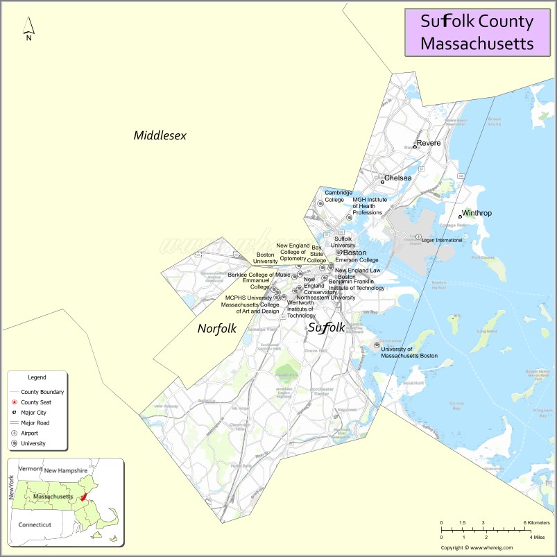
About Suffolk County Map, Massachusetts: The map showing the county boundary, county seat, major cities, highways, water bodies and neighbouring counties.
Other Massachusetts Maps & Info
Map of Suffolk County, Massachusetts
Suffolk County is a county located in the U.S. state of Massachusetts. It's county seat is Boston. As per 2020 census, the population of Suffolk County is 771245 people and population density is square miles. According to the United States Census Bureau, the county has a total area of 58 sq mi (150 km2). Suffolk County was established on 1643.
Suffolk County Facts
| Continent | North America |
| Country | United States |
| State | Massachusetts |
| County Seat | Boston |
| Largest City/Town | Boston |
| Established | 1643 |
| Total Area | 120 sq mi |
| Land Area | 58 sq mi |
| Water Area | 62 sq mi |
| Population | 797,936 (Census 2020) |
| Population Density | 13,757 people per sq mi |
| Time Zone | Eastern Time Zone (ET) |
| Major Highways | I-90, I-93, US-1, MA-1A, MA-28 |
| Neighboring Counties | Middlesex County, Norfolk County, Essex County |
| Famous For | Boston, American Revolution history, universities, waterfront |
| Top Attractions | Freedom Trail, Boston Common, Fenway Park, Boston Harbor |
| Official Website | https://www.sec.state.ma.us/cis/cissuf/suffidx.htm |
Ctities in Suffolk county
| City Name | Type | Population (2020) | Pop. Density | Area | Incorporated |
|---|---|---|---|---|---|
| Chelsea | City | 40,787 | 2.5 sq mi (6.47 km2) sq mi | 1739 | |
| Revere | City | 62,186 | 10.1 sq mi (26.16 km2) sq mi | 1846 | |
| Winthrop | City[a] | 19,316 | 8.3 sq mi (21.50 km2) sq mi | 1852 | |
| Boston | City | 675,647 | 89.6 sq mi (232.06 km2) sq mi | 1630 |
Roads and Highways in Suffolk County, Massachusetts
Suffolk County has a dense network of highways that support travel within Boston and connect to surrounding regions.
- Interstate 90 (Massachusetts Turnpike) – runs east-west through Boston and connects to western Massachusetts
- Interstate 93 – major north-south route through downtown Boston
- U.S. Route 1 – connects Boston to New Hampshire and Maine
- Massachusetts Route 1A – coastal route serving Logan Airport and nearby communities
- Massachusetts Route 28 – runs through Boston and connects to northern suburbs
Neighboring Counties of Suffolk County
- Essex County (north)
- Middlesex County (west)
- Norfolk County (south)
Top Attractions in Suffolk County, Massachusetts
Suffolk County is home to Boston, offering a rich mix of history, culture, and urban attractions.
- Freedom Trail – historic walking route through key Revolutionary War sites
- Boston Common – oldest public park in the United States
- Fenway Park – iconic baseball stadium home to the Boston Red Sox
- Boston Harbor – scenic waterfront with ferry tours and views
- New England Aquarium – popular attraction featuring marine life exhibits
- Faneuil Hall Marketplace – historic shopping and dining area
- North End – historic neighborhood known for Italian cuisine
- Isabella Stewart Gardner Museum – unique museum with art and gardens
Distance from Suffolk County to Nearby Cities
- Boston to Cambridge – 5 mi (8 km)
- Boston to Worcester – 50 mi (80 km)
- Boston to Providence – 50 mi (80 km)
- Boston to Hartford – 100 mi (161 km)
- Boston to New York City – 215 mi (346 km)
FAQs about Suffolk County
Suffolk County is located in eastern Massachusetts along the Atlantic coast and includes the city of Boston.
It is known for Boston, its role in the American Revolution, and major cultural and educational institutions.
Boston is the largest city and serves as the county seat.
Yes, it is one of the most densely populated counties in Massachusetts.
Main highways include I-90, I-93, U.S. Route 1, and Route 1A.
- Alabama Counties
- Alaska boroughs
- Arizona Counties
- Arkansas Counties
- California County Map
- Colorado Counties
- Connecticut Counties
- Delaware Counties
- Florida County Map
- Georgia County Map
- Hawaii Counties
- Idaho Counties
- Illinois Counties
- Indiana Counties
- Iowa Counties
- Kansas Counties
- Kentucky Counties
- Louisiana Counties
- Maine Counties
- Maryland Counties
- Massachusetts Counties
- Michigan County Map
- Minnesota Counties
- Mississippi Counties
- Missouri Counties
- Montana Counties
- Nebraska Counties
- Nevada Counties
- New York Counties
- New Hampshire Counties
- New Jersey Counties
- New Mexico Counties
- North Carolina Counties
- North Dakota Counties
- Ohio County Map
- Oklahoma Counties
- Oregon Counties
- Pennsylvania Counties
- Rhode Island Counties
- South Carolina Counties
- South Dakota Counties
- Map of Tennessee
- Texas County Map
- Utah Counties
- Vermont Counties
- Virginia Counties
- Washington Counties
- West Virginia Counties
- Wisconsin Counties
- Wyoming Counties
Written and fact-checked by Whereig.com Web Team | Last Updated: January 27, 2025, 12:15 PM ET