
Map of Berkshire County - Berkshire County is a county located in the U.S. state of Massachusetts. Berkshire County Map showing cities, highways, important places and water bodies. Get Where is Berkshire County located in the map, major cities in Berkshire county, population, areas, and places of interest.
Map of Berkshire County, Massachusetts
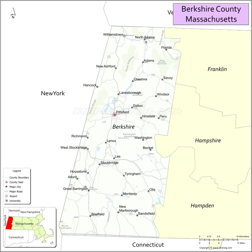
About Berkshire County Map, Massachusetts: The map showing the county boundary, county seat, major cities, highways, water bodies and neighbouring counties.
Other Massachusetts Maps & Info
Map of Berkshire County, Massachusetts
Berkshire County is a county located in the U.S. state of Massachusetts. It's county seat is Pittsfield. As per 2020 census, the population of Berkshire County is 128657 people and population density is square miles. According to the United States Census Bureau, the county has a total area of 931 sq mi (2,411 km2). Berkshire County was established on 1761.
Berkshire County Facts
| Continent | North America |
| Country | United States |
| State | Massachusetts |
| County Seat | Pittsfield |
| Largest City/Town | Pittsfield |
| Established | 1761 |
| Total Area | 946 sq mi |
| Land Area | 927 sq mi |
| Water Area | 19 sq mi |
| Population | 129,026 (Census 2020) |
| Population Density | 139 people per sq mi |
| Time Zone | Eastern Time Zone (ET) |
| Major Highways | I-90, US-7, US-20, MA-8, MA-9 |
| Neighboring Counties | Franklin County, Hampshire County, Hampden County, Columbia County (NY), Rensselaer County (NY), Bennington County (VT) |
| Famous For | Berkshire Mountains, cultural festivals, Tanglewood, scenic landscapes |
| Top Attractions | Tanglewood, Mount Greylock, Norman Rockwell Museum, The Clark Art Institute |
| Official Website | https://www.berkshirecountyma.gov |
Ctities in Berkshire county
| City Name | Type | Population (2020) | Pop. Density | Area | Incorporated |
|---|---|---|---|---|---|
| Adams | Town | 8,166 | 23.0 sq mi (59.57 km2) sq mi | 1778 | |
| Alford | Town | 486 | 11.5 sq mi (29.78 km2) sq mi | 1773 | |
| Becket | Town | 1,931 | 47.8 sq mi (123.80 km2) sq mi | 1765 | |
| Cheshire | Town | 3,258 | 27.5 sq mi (71.22 km2) sq mi | 1793 | |
| Clarksburg | Town | 1,657 | 12.8 sq mi (33.15 km2) sq mi | 1798 | |
| Dalton | Town | 6,330 | 21.9 sq mi (56.72 km2) sq mi | 1784 | |
| Egremont | Town | 1,372 | 18.9 sq mi (48.95 km2) sq mi | 1775 | |
| Florida | Town | 694 | 24.6 sq mi (63.71 km2) sq mi | 1805 | |
| Great Barrington | Town | 7,172 | 45.8 sq mi (118.62 km2) sq mi | 1761 | |
| Hancock | Town | 757 | 35.8 sq mi (92.72 km2) sq mi | 1776 | |
| Hinsdale | Town | 1,919 | 21.7 sq mi (56.20 km2) sq mi | 1804 | |
| Lanesborough | Town | 3,038 | 29.6 sq mi (76.66 km2) sq mi | 1765 | |
| Lee | Town | 5,788 | 27.0 sq mi (69.93 km2) sq mi | 1777 | |
| Lenox | Town | 5,095 | 21.7 sq mi (56.20 km2) sq mi | 1775 | |
| Monterey | Town | 1,095 | 27.4 sq mi (70.97 km2) sq mi | 1847 | |
| Mount Washington | Town | 160 | 22.4 sq mi (58.02 km2) sq mi | 1779 | |
| New Ashford | Town | 250 | 13.5 sq mi (34.96 km2) sq mi | 1835 | |
| New Marlborough | Town | 1,528 | 47.9 sq mi (124.06 km2) sq mi | 1775 | |
| North Adams | City | 12,961 | 20.6 sq mi (53.35 km2) sq mi | 1878 | |
| Otis | Town | 1,634 | 38.0 sq mi (98.42 km2) sq mi | 1773 | |
| Peru | Town | 814 | 26.0 sq mi (67.34 km2) sq mi | 1771 | |
| Richmond | Town | 1,407 | 19.0 sq mi (49.21 km2) sq mi | 1765 | |
| Sandisfield | Town | 989 | 53.0 sq mi (137.27 km2) sq mi | 1762 | |
| Savoy | Town | 645 | 36.0 sq mi (93.24 km2) sq mi | 1797 | |
| Sheffield | Town | 3,327 | 48.6 sq mi (125.87 km2) sq mi | 1733 | |
| Stockbridge | Town | 2,018 | 23.7 sq mi (61.38 km2) sq mi | 1739 | |
| Tyringham | Town | 427 | 18.9 sq mi (48.95 km2) sq mi | 1762 | |
| Washington | Town | 494 | 38.8 sq mi (100.49 km2) sq mi | 1777 | |
| West Stockbridge | Town | 1,343 | 18.7 sq mi (48.43 km2) sq mi | 1775 | |
| Williamstown | Town | 7,513 | 46.9 sq mi (121.47 km2) sq mi | 1765 | |
| Windsor | Town | 831 | 35.2 sq mi (91.17 km2) sq mi | 1771 | |
| Pittsfield | City | 43,927 | 42.5 sq mi (110.07 km2) sq mi | 1761 |
Roads and Highways in Berkshire County, Massachusetts
Berkshire County is connected by major highways that run through the scenic western part of Massachusetts and link it to nearby states.
- Interstate 90 (Massachusetts Turnpike) – east-west route connecting Albany, NY to Boston
- U.S. Route 7 – north-south highway linking Connecticut, Massachusetts, and Vermont
- U.S. Route 20 – runs east-west across the county through Pittsfield and Lee
- Massachusetts Route 8 – connects Pittsfield to North Adams and southern Massachusetts
- Massachusetts Route 9 – links Pittsfield to Northampton and central Massachusetts
Neighboring Counties of Berkshire County
- Franklin County (north)
- Hampshire County (east)
- Hampden County (southeast)
- Columbia County, NY (west)
- Rensselaer County, NY (northwest)
- Bennington County, VT (north)
Top Attractions in Berkshire County, Massachusetts
Berkshire County is known for its mix of natural beauty and cultural attractions, making it a popular destination year-round.
- Tanglewood – summer home of the Boston Symphony Orchestra with outdoor concerts
- Mount Greylock – highest peak in Massachusetts with hiking trails and scenic views
- Norman Rockwell Museum – features the artist’s famous illustrations and exhibits
- The Clark Art Institute – world-class museum with art collections and gardens
- Mass MoCA – large contemporary art museum in North Adams
- Hancock Shaker Village – historic site showcasing Shaker life and architecture
- Jiminy Peak Mountain Resort – popular for skiing in winter and outdoor activities in summer
- Berkshire Botanical Garden – peaceful garden with seasonal displays and walking paths
Distance from Berkshire County to Nearby Cities
- Pittsfield to Boston – 135 mi (217 km)
- Pittsfield to Albany – 50 mi (80 km)
- Pittsfield to Springfield – 50 mi (80 km)
- Pittsfield to Hartford – 75 mi (121 km)
- Pittsfield to New York City – 140 mi (225 km)
FAQs about Berkshire County
Berkshire County is located in western Massachusetts, bordering New York and Vermont.
It is known for the Berkshire Mountains, cultural events, and attractions like Tanglewood and Mass MoCA.
Pittsfield is the largest city and serves as the county seat.
Yes, the area offers hiking, skiing, and scenic drives, especially around Mount Greylock.
Main highways include I-90, US-7, and US-20, connecting the region to major cities.
- Alabama Counties
- Alaska boroughs
- Arizona Counties
- Arkansas Counties
- California County Map
- Colorado Counties
- Connecticut Counties
- Delaware Counties
- Florida County Map
- Georgia County Map
- Hawaii Counties
- Idaho Counties
- Illinois Counties
- Indiana Counties
- Iowa Counties
- Kansas Counties
- Kentucky Counties
- Louisiana Counties
- Maine Counties
- Maryland Counties
- Massachusetts Counties
- Michigan County Map
- Minnesota Counties
- Mississippi Counties
- Missouri Counties
- Montana Counties
- Nebraska Counties
- Nevada Counties
- New York Counties
- New Hampshire Counties
- New Jersey Counties
- New Mexico Counties
- North Carolina Counties
- North Dakota Counties
- Ohio County Map
- Oklahoma Counties
- Oregon Counties
- Pennsylvania Counties
- Rhode Island Counties
- South Carolina Counties
- South Dakota Counties
- Map of Tennessee
- Texas County Map
- Utah Counties
- Vermont Counties
- Virginia Counties
- Washington Counties
- West Virginia Counties
- Wisconsin Counties
- Wyoming Counties
Written and fact-checked by Whereig.com Web Team | Last Updated: January 27, 2025, 12:15 PM ET