Map of Plymouth County - Plymouth County is a county located in the U.S. state of Massachusetts. Plymouth County Map showing cities, highways, important places and water bodies. Get Where is Plymouth County located in the map, major cities in Plymouth county, population, areas, and places of interest.
Map of Plymouth County, Massachusetts
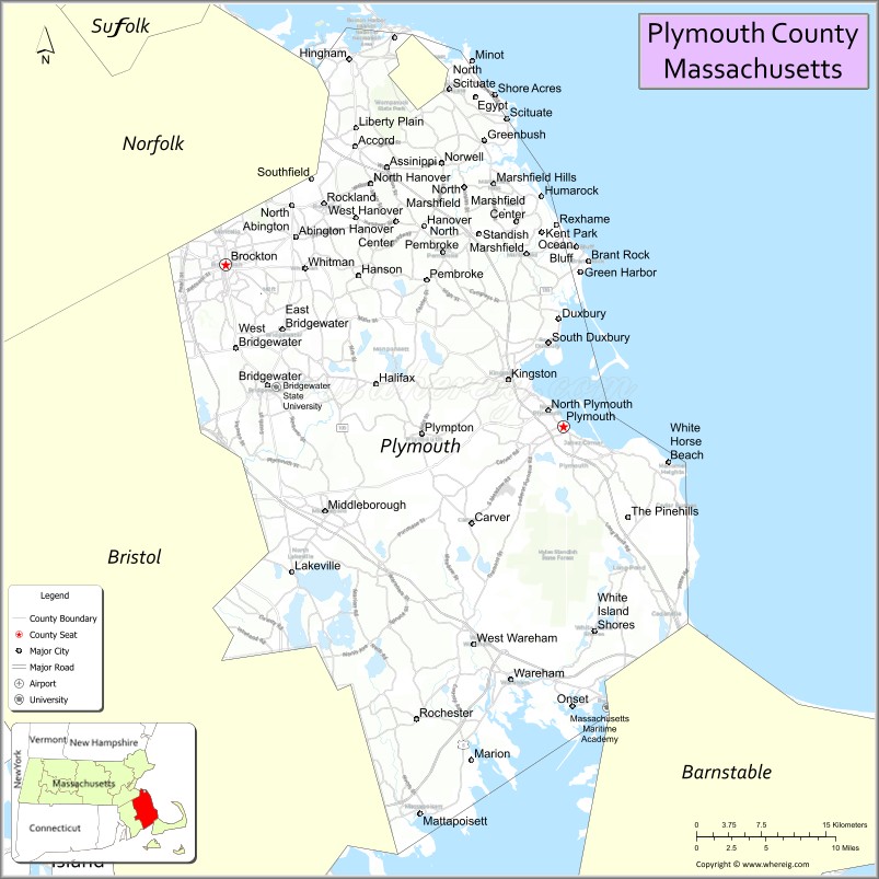
About Plymouth County Map, Massachusetts: The map showing the county boundary, county seat, major cities, highways, water bodies and neighbouring counties.
Other Massachusetts Maps & Info
Map of Plymouth County, Massachusetts
"Plymouth County is a county located in the U.S. state of Massachusetts. It's county seat is Brockton, Plymouth. As per 2020 census, the population of Plymouth County is 533003 people and population density is square miles. According to the United States Census Bureau, the county has a total area of 661 sq mi (1,712 km2). Plymouth County was established on 1685."
Plymouth County Facts
| Continent | North America |
| Country | United States |
| State | Massachusetts |
| County Seat | Plymouth |
| Largest City/Town | Brockton |
| Established | 1685 |
| Total Area | 1,093 sq mi |
| Land Area | 661 sq mi |
| Water Area | 432 sq mi |
| Population | 530,819 (Census 2020) |
| Population Density | 803 people per sq mi |
| Time Zone | Eastern Time Zone (ET) |
| Major Highways | I-93, MA-3, MA-24, US-44, MA-18 |
| Neighboring Counties | Norfolk County, Bristol County, Barnstable County |
| Famous For | Plymouth Rock, Pilgrim history, coastal towns, cranberry bogs |
| Top Attractions | Plymouth Rock, Plimoth Patuxet Museums, Myles Standish State Forest |
| Official Website | https://www.sec.state.ma.us/cis/cisply/plyidx.htm |
Ctities in Plymouth county
| City Name | Type | Population (2020) | Pop. Density | Area | Incorporated |
|---|---|---|---|---|---|
| Abington | Town | 17,062 | 9.9 sq mi (25.64 km2) sq mi | 1712 | |
| Bridgewater | City[a] | 28,633 | 28.2 sq mi (73.04 km2) sq mi | 1656 | |
| Carver | Town | 11,645 | 39.7 sq mi (102.82 km2) sq mi | 1790 | |
| Duxbury | Town | 16,090 | 37.6 sq mi (97.38 km2) sq mi | 1637 | |
| East Bridgewater | Town | 14,440 | 17.5 sq mi (45.32 km2) sq mi | 1823 | |
| Halifax | Town | 7,749 | 17.3 sq mi (44.81 km2) sq mi | 1734 | |
| Hanover | Town | 14,833 | 15.7 sq mi (40.66 km2) sq mi | 1727 | |
| Hanson | Town | 10,639 | 15.7 sq mi (40.66 km2) sq mi | 1820 | |
| Hingham | Town | 24,284 | 26.3 sq mi (68.12 km2) sq mi | 1635 | |
| Hull | Town | 10,072 | 26.9 sq mi (69.67 km2) sq mi | 1644 | |
| Kingston | Town | 13,708 | 20.5 sq mi (53.09 km2) sq mi | 1726 | |
| Lakeville | Town | 11,523 | 36.1 sq mi (93.50 km2) sq mi | 1853 | |
| Marion | Town | 5,347 | 26.1 sq mi (67.60 km2) sq mi | 1852 | |
| Marshfield | Town | 25,825 | 31.7 sq mi (82.10 km2) sq mi | 1640 | |
| Mattapoisett | Town | 6,508 | 24.2 sq mi (62.68 km2) sq mi | 1857 | |
| Middleborough | Town | 24,245 | 72.2 sq mi (187.00 km2) sq mi | 1669 | |
| Norwell | Town | 11,351 | 21.2 sq mi (54.91 km2) sq mi | 1849 | |
| Pembroke | Town | 18,361 | 23.5 sq mi (60.86 km2) sq mi | 1712 | |
| Plympton | Town | 2,930 | 15.1 sq mi (39.11 km2) sq mi | 1707 | |
| Rochester | Town | 5,717 | 36.4 sq mi (94.28 km2) sq mi | 1686 | |
| Rockland | Town | 17,803 | 10.1 sq mi (26.16 km2) sq mi | 1874 | |
| Scituate | Town | 19,063 | 31.8 sq mi (82.36 km2) sq mi | 1636 | |
| Wareham | Town | 23,303 | 46.3 sq mi (119.92 km2) sq mi | 1739 | |
| West Bridgewater | Town | 7,707 | 15.7 sq mi (40.66 km2) sq mi | 1822 | |
| Whitman | Town | 15,121 | 7.1 sq mi (18.39 km2) sq mi | 1875 | |
| Brockton | City | 105,643 | 21.5 sq mi (55.68 km2) sq mi | 1821 | |
| Plymouth | Town | 61,217 | 134.0 sq mi (347.06 km2) sq mi | 1620 |
Roads and Highways in Plymouth County, Massachusetts
Plymouth County is served by key highways that connect its coastal communities to Boston and southeastern Massachusetts.
- Interstate 93 – connects the northern part of the county to Boston
- Massachusetts Route 3 – major route linking Boston to Cape Cod through Plymouth
- Massachusetts Route 24 – connects Brockton to Fall River and Boston
- U.S. Route 44 – east-west route connecting Plymouth to Taunton and Providence
- Massachusetts Route 18 – runs through Brockton and connects to coastal areas
Neighboring Counties of Plymouth County
- Norfolk County (north)
- Bristol County (west)
- Barnstable County (southeast, across Cape Cod Canal)
Top Attractions in Plymouth County, Massachusetts
Plymouth County is rich in American history and coastal scenery, making it a popular destination for visitors.
- Plymouth Rock – historic symbol of the Pilgrims’ landing in 1620
- Plimoth Patuxet Museums – living history museum showcasing early colonial life
- Myles Standish State Forest – large forest with trails, camping, and ponds
- Mayflower II – replica of the ship that brought the Pilgrims to America
- Duxbury Beach – scenic beach known for its coastal views
- World’s End – coastal park with walking trails in Hingham
- Ellisville Harbor State Park – quiet beach and nature area
- Brockton Fire Museum – highlights the city’s firefighting history
Distance from Plymouth County to Nearby Cities
- Plymouth to Boston – 40 mi (64 km)
- Brockton to Boston – 25 mi (40 km)
- Plymouth to Providence – 45 mi (72 km)
- Plymouth to Cape Cod – 20 mi (32 km)
- Brockton to Worcester – 50 mi (80 km)
FAQs about Plymouth County
Plymouth County is located in southeastern Massachusetts along the Atlantic coast.
It is known for its role in early American history, especially the Pilgrims and Plymouth Rock.
Brockton is the largest city, while Plymouth is the county seat.
Yes, it is one of the most historically significant areas in the United States.
Main highways include I-93, Route 3, and Route 24, connecting the county to Boston and surrounding regions.
- Alabama Counties
- Alaska boroughs
- Arizona Counties
- Arkansas Counties
- California County Map
- Colorado Counties
- Connecticut Counties
- Delaware Counties
- Florida County Map
- Georgia County Map
- Hawaii Counties
- Idaho Counties
- Illinois Counties
- Indiana Counties
- Iowa Counties
- Kansas Counties
- Kentucky Counties
- Louisiana Counties
- Maine Counties
- Maryland Counties
- Massachusetts Counties
- Michigan County Map
- Minnesota Counties
- Mississippi Counties
- Missouri Counties
- Montana Counties
- Nebraska Counties
- Nevada Counties
- New York Counties
- New Hampshire Counties
- New Jersey Counties
- New Mexico Counties
- North Carolina Counties
- North Dakota Counties
- Ohio County Map
- Oklahoma Counties
- Oregon Counties
- Pennsylvania Counties
- Rhode Island Counties
- South Carolina Counties
- South Dakota Counties
- Map of Tennessee
- Texas County Map
- Utah Counties
- Vermont Counties
- Virginia Counties
- Washington Counties
- West Virginia Counties
- Wisconsin Counties
- Wyoming Counties
Written and fact-checked by Whereig.com Web Team | Last Updated: January 27, 2025, 12:15 PM ET