Map of Middlesex County - Middlesex County is a county located in the U.S. state of Massachusetts. Middlesex County Map showing cities, highways, important places and water bodies. Get Where is Middlesex County located in the map, major cities in Middlesex county, population, areas, and places of interest.
Map of Middlesex County, Massachusetts
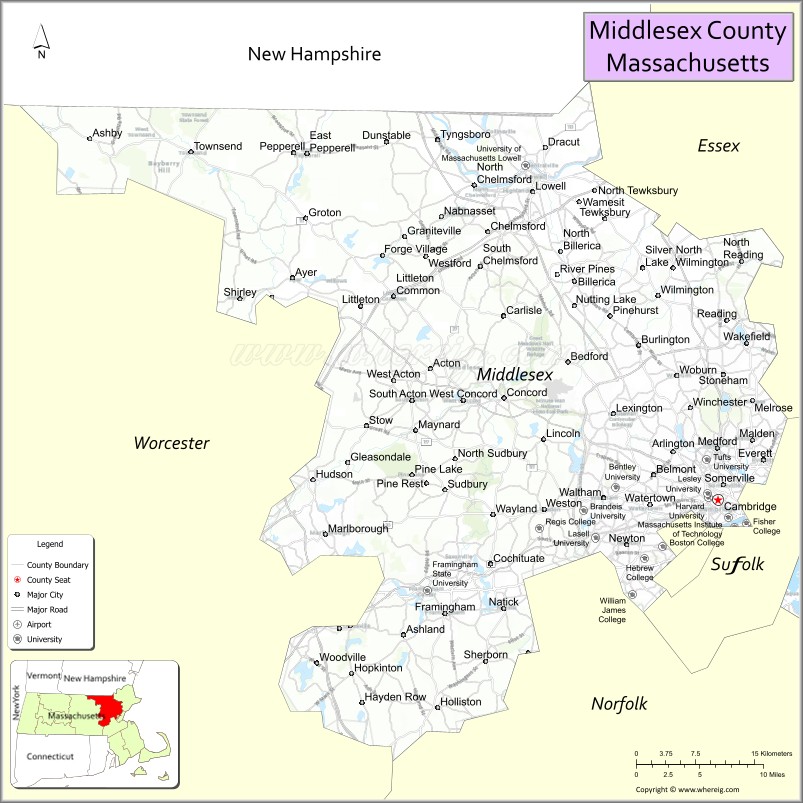
About Middlesex County Map, Massachusetts: The map showing the county boundary, county seat, major cities, highways, water bodies and neighbouring counties.
Other Massachusetts Maps & Info
Map of Middlesex County, Massachusetts
"Middlesex County is a county located in the U.S. state of Massachusetts. It's county seat is Lowell, Cambridge. As per 2020 census, the population of Middlesex County is 1614742 people and population density is square miles. According to the United States Census Bureau, the county has a total area of 824 sq mi (2,134 km2). Middlesex County was established on 1643."
Middlesex County Facts
| Continent | North America |
| Country | United States |
| State | Massachusetts |
| County Seat | Lowell and Cambridge |
| Largest City/Town | Lowell |
| Established | 1643 |
| Total Area | 847 sq mi |
| Land Area | 818 sq mi |
| Water Area | 29 sq mi |
| Population | 1,632,002 (Census 2020) |
| Population Density | 1,995 people per sq mi |
| Time Zone | Eastern Time Zone (ET) |
| Major Highways | I-95, I-93, I-495, US-3, US-20, MA-2 |
| Neighboring Counties | Essex County, Suffolk County, Norfolk County, Worcester County, Hillsborough County (NH) |
| Famous For | Harvard University, MIT, historic mill cities, technology and education hubs |
| Top Attractions | Harvard University, MIT, Minute Man National Historical Park, Lowell National Historical Park |
| Official Website | https://www.sec.state.ma.us/cis/cismidd/middidx.htm |
Ctities in Middlesex county
| City Name | Type | Population (2020) | Pop. Density | Area | Incorporated |
|---|---|---|---|---|---|
| Acton | Town | 24,021 | 20.3 sq mi (52.58 km2) sq mi | 1735 | |
| Arlington | Town | 46,308 | 5.5 sq mi (14.24 km2) sq mi | 1807 | |
| Ashby | Town | 3,193 | 24.2 sq mi (62.68 km2) sq mi | 1767 | |
| Ashland | Town | 18,832 | 12.9 sq mi (33.41 km2) sq mi | 1846 | |
| Ayer | Town | 8,479 | 9.6 sq mi (24.86 km2) sq mi | 1871 | |
| Bedford | Town | 14,383 | 13.9 sq mi (36.00 km2) sq mi | 1729 | |
| Belmont | Town | 27,295 | 4.7 sq mi (12.17 km2) sq mi | 1859 | |
| Billerica | Town | 42,119 | 26.4 sq mi (68.38 km2) sq mi | 1655 | |
| Boxborough | Town | 5,506 | 10.4 sq mi (26.94 km2) sq mi | 1835 | |
| Burlington | Town | 26,377 | 11.9 sq mi (30.82 km2) sq mi | 1799 | |
| Carlisle | Town | 5,237 | 15.6 sq mi (40.40 km2) sq mi | 1780 | |
| Chelmsford | Town | 36,392 | 23.2 sq mi (60.09 km2) sq mi | 1655 | |
| Concord | Town | 18,491 | 25.9 sq mi (67.08 km2) sq mi | 1635 | |
| Dracut | Town | 32,617 | 21.4 sq mi (55.43 km2) sq mi | 1701 | |
| Dunstable | Town | 3,358 | 16.7 sq mi (43.25 km2) sq mi | 1673 | |
| Everett | City | 49,075 | 3.7 sq mi (9.58 km2) sq mi | 1870 | |
| Framingham | City | 72,362 | 26.5 sq mi (68.63 km2) sq mi | 1700 | |
| Groton | Town | 11,315 | 33.7 sq mi (87.28 km2) sq mi | 1655 | |
| Holliston | Town | 14,996 | 19.0 sq mi (49.21 km2) sq mi | 1724 | |
| Hopkinton | Town | 18,758 | 28.2 sq mi (73.04 km2) sq mi | 1715 | |
| Hudson | Town | 20,092 | 11.8 sq mi (30.56 km2) sq mi | 1866 | |
| Lexington | Town | 34,454 | 16.5 sq mi (42.73 km2) sq mi | 1713 | |
| Lincoln | Town | 7,014 | 15.0 sq mi (38.85 km2) sq mi | 1754 | |
| Littleton | Town | 10,141 | 17.6 sq mi (45.58 km2) sq mi | 1715 | |
| Malden | City | 66,263 | 5.1 sq mi (13.21 km2) sq mi | 1649 | |
| Marlborough | City | 41,793 | 22.1 sq mi (57.24 km2) sq mi | 1660 | |
| Maynard | Town | 10,746 | 5.4 sq mi (13.99 km2) sq mi | 1871 | |
| Medford | City | 59,659 | 8.7 sq mi (22.53 km2) sq mi | 1630 | |
| Melrose | City | 29,817 | 4.8 sq mi (12.43 km2) sq mi | 1850 | |
| Natick | Town | 37,006 | 16.1 sq mi (41.70 km2) sq mi | 1781 | |
| Newton | City | 88,923 | 18.2 sq mi (47.14 km2) sq mi | 1688 | |
| North Reading | Town | 15,554 | 13.5 sq mi (34.96 km2) sq mi | 1853 | |
| Pepperell | Town | 11,604 | 23.2 sq mi (60.09 km2) sq mi | 1775 | |
| Reading | Town | 25,518 | 9.9 sq mi (25.64 km2) sq mi | 1644 | |
| Sherborn | Town | 4,401 | 16.2 sq mi (41.96 km2) sq mi | 1674 | |
| Shirley | Town | 7,431 | 15.9 sq mi (41.18 km2) sq mi | 1775 | |
| Somerville | City | 81,045 | 4.2 sq mi (10.88 km2) sq mi | 1842 | |
| Stoneham | Town | 23,244 | 6.7 sq mi (17.35 km2) sq mi | 1725 | |
| Stow | Town | 7,174 | 18.1 sq mi (46.88 km2) sq mi | 1683 | |
| Sudbury | Town | 18,934 | 24.6 sq mi (63.71 km2) sq mi | 1639 | |
| Tewksbury | Town | 31,342 | 21.1 sq mi (54.65 km2) sq mi | 1734 | |
| Townsend | Town | 9,127 | 33.1 sq mi (85.73 km2) sq mi | 1732 | |
| Tyngsborough | Town | 12,380 | 18.1 sq mi (46.88 km2) sq mi | 1809 | |
| Wakefield | Town | 27,090 | 7.9 sq mi (20.46 km2) sq mi | 1812 | |
| Waltham | City | 65,218 | 13.8 sq mi (35.74 km2) sq mi | 1738 | |
| Watertown | City[8] | 35,329 | 4.1 sq mi (10.62 km2) sq mi | 1630 | |
| Wayland | Town | 13,943 | 15.9 sq mi (41.18 km2) sq mi | 1780 | |
| Westford | Town | 24,643 | 31.3 sq mi (81.07 km2) sq mi | 1729 | |
| Weston | Town | 11,851 | 17.3 sq mi (44.81 km2) sq mi | 1713 | |
| Wilmington | Town | 23,349 | 17.2 sq mi (44.55 km2) sq mi | 1730 | |
| Winchester | Town | 22,970 | 6.3 sq mi (16.32 km2) sq mi | 1850 | |
| Woburn | City | 40,876 | 12.9 sq mi (33.41 km2) sq mi | 1642 | |
| Cambridge | City | 118,403 | 7.1 sq mi (18.39 km2) sq mi | 1636 | |
| Lowell | City | 115,554 | 14.5 sq mi (37.55 km2) sq mi | 1826 |
Roads and Highways in Middlesex County, Massachusetts
Middlesex County has a dense highway network that connects it to Boston, New Hampshire, and other parts of New England.
- Interstate 95 – major beltway around Boston connecting multiple suburbs
- Interstate 93 – north-south route linking Boston to New Hampshire
- Interstate 495 – outer loop connecting regional cities and towns
- U.S. Route 3 – connects Cambridge to Lowell and into New Hampshire
- U.S. Route 20 – east-west highway through southern Middlesex County
- Massachusetts Route 2 – major route connecting Cambridge to western Massachusetts
Neighboring Counties of Middlesex County
- Essex County (north)
- Hillsborough County, NH (northwest)
- Worcester County (west)
- Norfolk County (south)
- Suffolk County (east)
Top Attractions in Middlesex County, Massachusetts
Middlesex County blends history, education, and innovation, with attractions ranging from historic sites to world-renowned universities.
- Harvard University – historic Ivy League campus in Cambridge
- Massachusetts Institute of Technology (MIT) – leading research university along the Charles River
- Minute Man National Historical Park – site of early battles of the American Revolution
- Lowell National Historical Park – showcases the city’s industrial past
- Walden Pond State Reservation – famous natural site linked to Henry David Thoreau
- Lexington Battle Green – historic site of the first shots of the Revolution
- Somerville’s Assembly Row – modern shopping and entertainment district
- Great Brook Farm State Park – scenic area for hiking and farming activities
Distance from Middlesex County to Nearby Cities
- Cambridge to Boston – 5 mi (8 km)
- Lowell to Manchester, NH – 30 mi (48 km)
- Newton to Worcester – 40 mi (64 km)
- Cambridge to Providence – 50 mi (80 km)
- Lowell to Hartford – 90 mi (145 km)
FAQs about Middlesex County
Middlesex County is located in northeastern Massachusetts, surrounding the Boston metropolitan area.
It is known for prestigious universities like Harvard and MIT, as well as its role in American history and technology.
The county has two seats: Cambridge and Lowell.
Lowell is the largest city by population, followed closely by Cambridge.
Main highways include I-95, I-93, I-495, U.S. Route 3, and Massachusetts Route 2.
- Alabama Counties
- Alaska boroughs
- Arizona Counties
- Arkansas Counties
- California County Map
- Colorado Counties
- Connecticut Counties
- Delaware Counties
- Florida County Map
- Georgia County Map
- Hawaii Counties
- Idaho Counties
- Illinois Counties
- Indiana Counties
- Iowa Counties
- Kansas Counties
- Kentucky Counties
- Louisiana Counties
- Maine Counties
- Maryland Counties
- Massachusetts Counties
- Michigan County Map
- Minnesota Counties
- Mississippi Counties
- Missouri Counties
- Montana Counties
- Nebraska Counties
- Nevada Counties
- New York Counties
- New Hampshire Counties
- New Jersey Counties
- New Mexico Counties
- North Carolina Counties
- North Dakota Counties
- Ohio County Map
- Oklahoma Counties
- Oregon Counties
- Pennsylvania Counties
- Rhode Island Counties
- South Carolina Counties
- South Dakota Counties
- Map of Tennessee
- Texas County Map
- Utah Counties
- Vermont Counties
- Virginia Counties
- Washington Counties
- West Virginia Counties
- Wisconsin Counties
- Wyoming Counties
Written and fact-checked by Whereig.com Web Team | Last Updated: January 27, 2025, 12:15 PM ET