Map of Bristol County - Bristol County is a county located in the U.S. state of Massachusetts. Bristol County Map showing cities, highways, important places and water bodies. Get Where is Bristol County located in the map, major cities in Bristol county, population, areas, and places of interest.
Map of Bristol County, Massachusetts
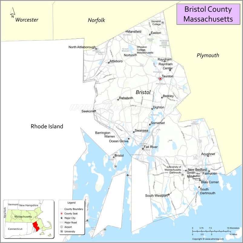
About Bristol County Map, Massachusetts: The map showing the county boundary, county seat, major cities, highways, water bodies and neighbouring counties.
Other Massachusetts Maps & Info
Map of Bristol County, Massachusetts
Bristol County is a county located in the U.S. state of Massachusetts. It's county seat is Taunton. As per 2020 census, the population of Bristol County is 580164 people and population density is square miles. According to the United States Census Bureau, the county has a total area of 556 sq mi (1,440 km2). Bristol County was established on 1685.
Bristol County Facts
| Continent | North America |
| Country | United States |
| State | Massachusetts |
| County Seat | Taunton |
| Largest City/Town | New Bedford |
| Established | 1685 |
| Total Area | 691 sq mi |
| Land Area | 553 sq mi |
| Water Area | 138 sq mi |
| Population | 579,200 (Census 2020) |
| Population Density | 1,047 people per sq mi |
| Time Zone | Eastern Time Zone (ET) |
| Major Highways | I-195, I-495, US-6, MA-24, MA-79, MA-140 |
| Neighboring Counties | Plymouth County, Norfolk County, Middlesex County, Providence County (RI), Newport County (RI) |
| Famous For | Whaling history, coastal cities, Fall River mills, New Bedford fishing industry |
| Top Attractions | New Bedford Whaling Museum, Battleship Cove, Fall River Heritage State Park, Horseneck Beach |
| Official Website | https://www.sec.state.ma.us/cis/cisbco/bcointro.htm |
Ctities in Bristol county
| City Name | Type | Population (2020) | Pop. Density | Area | Incorporated |
|---|---|---|---|---|---|
| Acushnet | Town | 10,559 | 19.0 sq mi (49.21 km2) sq mi | 1860 | |
| Attleboro | City | 46,461 | 27.8 sq mi (72.00 km2) sq mi | 1694 | |
| Berkley | Town | 6,764 | 17.4 sq mi (45.07 km2) sq mi | 1735 | |
| Dartmouth | Town | 33,783 | 97.5 sq mi (252.52 km2) sq mi | 1664 | |
| Dighton | Town | 8,101 | 22.6 sq mi (58.53 km2) sq mi | 1712 | |
| Easton | Town | 25,058 | 29.2 sq mi (75.63 km2) sq mi | 1725 | |
| Fairhaven | Town | 15,924 | 14.1 sq mi (36.52 km2) sq mi | 1812 | |
| Fall River | City | 94,000 | 40.2 sq mi (104.12 km2) sq mi | 1803 | |
| Freetown | Town | 9,206 | 38.3 sq mi (99.20 km2) sq mi | 1683 | |
| Mansfield | Town | 23,860 | 20.7 sq mi (53.61 km2) sq mi | 1775 | |
| New Bedford | City | 101,079 | 24.1 sq mi (62.42 km2) sq mi | 1787 | |
| North Attleborough | City[a] | 30,834 | 19.1 sq mi (49.47 km2) sq mi | 1887 | |
| Norton | Town | 19,202 | 29.8 sq mi (77.18 km2) sq mi | 1711 | |
| Raynham | Town | 15,142 | 20.9 sq mi (54.13 km2) sq mi | 1731 | |
| Rehoboth | Town | 12,502 | 46.8 sq mi (121.21 km2) sq mi | 1645 | |
| Seekonk | Town | 15,531 | 18.3 sq mi (47.40 km2) sq mi | 1812 | |
| Somerset | Town | 18,303 | 12.0 sq mi (31.08 km2) sq mi | 1790 | |
| Swansea | Town | 17,144 | 25.5 sq mi (66.04 km2) sq mi | 1667 | |
| Westport | Town | 16,339 | 64.4 sq mi (166.80 km2) sq mi | 1787 | |
| Taunton | City | 59,408 | 48.4 sq mi (125.36 km2) sq mi | 1639 |
Roads and Highways in Bristol County, Massachusetts
Bristol County is served by several major highways that connect it to Boston, Providence, and other parts of southeastern New England.
- Interstate 195 – east-west route connecting Providence, RI to Cape Cod via New Bedford
- Interstate 495 – outer beltway linking the county to Greater Boston and other regions
- U.S. Route 6 – runs through Fall River and connects to Cape Cod
- Massachusetts Route 24 – connects Fall River and Taunton to Boston
- Massachusetts Route 79 – runs along the Taunton River through Fall River
- Massachusetts Route 140 – links New Bedford to Taunton and northern Massachusetts
Neighboring Counties of Bristol County
- Plymouth County (east)
- Norfolk County (north)
- Middlesex County (north)
- Providence County, RI (west)
- Newport County, RI (southwest, across water)
Top Attractions in Bristol County, Massachusetts
Bristol County blends coastal scenery, maritime history, and urban attractions that reflect its rich past and vibrant communities.
- New Bedford Whaling Museum – explores the city’s whaling heritage and maritime history
- Battleship Cove – features historic naval ships open for tours in Fall River
- Fall River Heritage State Park – waterfront park with views of the Taunton River
- Horseneck Beach State Reservation – popular beach for swimming, fishing, and camping
- Buttonwood Park Zoo – small family-friendly zoo in New Bedford
- Old Colony History Museum – highlights Taunton’s local history and artifacts
- Fort Phoenix State Reservation – historic coastal fort with beach access
- Capron Park – green space with zoo and walking trails in Attleboro
Distance from Bristol County to Nearby Cities
- Taunton to Boston – 40 mi (64 km)
- Taunton to Providence – 20 mi (32 km)
- New Bedford to Cape Cod – 30 mi (48 km)
- Fall River to Newport – 20 mi (32 km)
- Taunton to Hartford – 95 mi (153 km)
FAQs about Bristol County
Bristol County is located in southeastern Massachusetts, bordering Rhode Island and the Atlantic coast.
It is known for its maritime history, especially in New Bedford, and historic mill cities like Fall River.
New Bedford is the largest city, followed closely by Fall River.
Yes, the county directly borders Rhode Island and has strong regional connections with Providence.
Major highways include I-195, I-495, US-6, and MA-24, making travel across the region convenient.
- Alabama Counties
- Alaska boroughs
- Arizona Counties
- Arkansas Counties
- California County Map
- Colorado Counties
- Connecticut Counties
- Delaware Counties
- Florida County Map
- Georgia County Map
- Hawaii Counties
- Idaho Counties
- Illinois Counties
- Indiana Counties
- Iowa Counties
- Kansas Counties
- Kentucky Counties
- Louisiana Counties
- Maine Counties
- Maryland Counties
- Massachusetts Counties
- Michigan County Map
- Minnesota Counties
- Mississippi Counties
- Missouri Counties
- Montana Counties
- Nebraska Counties
- Nevada Counties
- New York Counties
- New Hampshire Counties
- New Jersey Counties
- New Mexico Counties
- North Carolina Counties
- North Dakota Counties
- Ohio County Map
- Oklahoma Counties
- Oregon Counties
- Pennsylvania Counties
- Rhode Island Counties
- South Carolina Counties
- South Dakota Counties
- Map of Tennessee
- Texas County Map
- Utah Counties
- Vermont Counties
- Virginia Counties
- Washington Counties
- West Virginia Counties
- Wisconsin Counties
- Wyoming Counties
Written and fact-checked by Whereig.com Web Team | Last Updated: January 27, 2025, 12:15 PM ET