
Essex County Map, Massachusettsa, USA

Written and Fact-checked by | Updated On: April 30, 2026 | 14:01 ET

Map of Essex County - Essex County is a county located in the U.S. state of Massachusetts. Essex County Map showing cities, highways, important places and water bodies. Get Where is Essex County located in the map, major cities in Essex county, population, areas, and places of interest.

Map of Essex County, Massachusetts
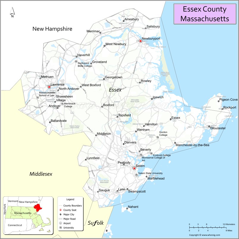
Map of Essex County, Massachusetts

About Essex County Map, Massachusetts: The map showing the county boundary, county seat, major cities, highways, water bodies and neighbouring counties.

Other Massachusetts Maps & Info

Massachusetts MapMassachusetts County MapMap of Massachusetts With Cities
Massachusetts ZipcodesWhere is Harvard UniversityWhere is Massachusetts
Massachusetts Area CodesMassachusetts Blank MapMassachusetts River Map
Massachusetts Physical MapMassachusetts Road MapWhere is Boston

Map of Essex County, Massachusetts

"Essex County is a county located in the U.S. state of Massachusetts. It's county seat is Salem, Lawrence. As per 2020 census, the population of Essex County is 807074 people and population density is square miles. According to the United States Census Bureau, the county has a total area of 498 sq mi (1,290 km2). Essex County was established on 1643."

Essex County Facts

ContinentNorth America
CountryUnited States
StateMassachusetts
County SeatSalem and Lawrence
Largest City/TownHaverhill
Established1643
Total Area828 sq mi
Land Area493 sq mi
Water Area335 sq mi
Population809,829 (Census 2020)
Population Density1,642 people per sq mi
Time ZoneEastern Time Zone (ET)
Major HighwaysI-95, I-93, I-495, US-1, MA-1A, MA-114
Neighboring CountiesMiddlesex County, Suffolk County, Rockingham County (NH)
Famous ForSalem witch trials, historic seaports, coastal towns, industry
Top AttractionsSalem Historic District, Cape Ann, Plum Island, Peabody Essex Museum
Official Websitehttps://www.sec.state.ma.us/cis/cisesx/essexidx.htm

Ctities in Essex county

City NameTypePopulation (2020)Pop. DensityAreaIncorporated
AmesburyCity17,366 13.7 sq mi (35.48 km2) sq mi1668
AndoverTown36,569 32.1 sq mi (83.14 km2) sq mi1646
BeverlyCity42,670 22.6 sq mi (58.53 km2) sq mi1668
BoxfordTown8,203 24.4 sq mi (63.20 km2) sq mi1685
DanversTown28,087 14.1 sq mi (36.52 km2) sq mi1775
EssexTown3,675 15.9 sq mi (41.18 km2) sq mi1819
GeorgetownTown8,470 13.2 sq mi (34.19 km2) sq mi1838
GloucesterCity29,729 41.5 sq mi (107.48 km2) sq mi1623
GrovelandTown6,752 9.4 sq mi (24.35 km2) sq mi1850
HamiltonTown7,561 14.9 sq mi (38.59 km2) sq mi1793
HaverhillCity67,787 35.7 sq mi (92.46 km2) sq mi1641
IpswichTown13,785 42.5 sq mi (110.07 km2) sq mi1634
LynnCity101,253 13.5 sq mi (34.96 km2) sq mi1629
LynnfieldTown13,000 10.5 sq mi (27.19 km2) sq mi1814
Manchester-by-the-SeaTown5,395 18.3 sq mi (47.40 km2) sq mi1645
MarbleheadTown20,441 19.6 sq mi (50.76 km2) sq mi1629
MerrimacTown6,723 8.8 sq mi (22.79 km2) sq mi1876
MethuenCity[a]53,039 23.0 sq mi (59.57 km2) sq mi1725
MiddletonTown9,779 14.5 sq mi (37.55 km2) sq mi1728
NahantTown3,334 15.5 sq mi (40.14 km2) sq mi1853
NewburyTown6,716 26.3 sq mi (68.12 km2) sq mi1635
NewburyportCity18,289 10.7 sq mi (27.71 km2) sq mi1764
North AndoverTown30,915 27.8 sq mi (72.00 km2) sq mi1855
PeabodyCity54,481 16.8 sq mi (43.51 km2) sq mi1868
RockportTown6,992 17.5 sq mi (45.32 km2) sq mi1840
RowleyTown6,161 20.3 sq mi (52.58 km2) sq mi1639
SalisburyTown9,236 17.9 sq mi (46.36 km2) sq mi1639
SaugusTown28,619 11.8 sq mi (30.56 km2) sq mi1815
SwampscottTown15,111 6.7 sq mi (17.35 km2) sq mi1852
TopsfieldTown6,569 12.8 sq mi (33.15 km2) sq mi1650
WenhamTown4,979 8.1 sq mi (20.98 km2) sq mi1643
West NewburyTown4,500 14.7 sq mi (38.07 km2) sq mi1819
LawrenceCity89,143 7.4 sq mi (19.17 km2) sq mi1847
SalemCity44,480 18.3 sq mi (47.40 km2) sq mi1626

Roads and Highways in Essex County, Massachusetts

Essex County is served by a strong network of highways that connect coastal cities and inland communities to Boston and New Hampshire.

Neighboring Counties of Essex County

Top Attractions in Essex County, Massachusetts

Essex County is rich in history, coastal scenery, and cultural landmarks that draw visitors year-round.

Distance from Essex County to Nearby Cities

FAQs about Essex County

Where is Essex County located?

Essex County is located in northeastern Massachusetts along the Atlantic coast, bordering New Hampshire.

What is Essex County known for?

It is known for the Salem witch trials, historic coastal towns, and cultural attractions.

What are the county seats of Essex County?

Essex County has two county seats: Salem and Lawrence.

What is the largest city in Essex County?

Lynn is the largest city by population, followed by Lawrence and Haverhill.

Which highways run through Essex County?

Main highways include I-95, I-93, I-495, and U.S. Route 1, connecting the county to major regions.

Written and fact-checked by | Last Updated: January 27, 2025, 12:15 PM ET