Map of Hampden County - Hampden County is a county located in the U.S. state of Massachusetts. Hampden County Map showing cities, highways, important places and water bodies. Get Where is Hampden County located in the map, major cities in Hampden county, population, areas, and places of interest.
Map of Hampden County, Massachusetts
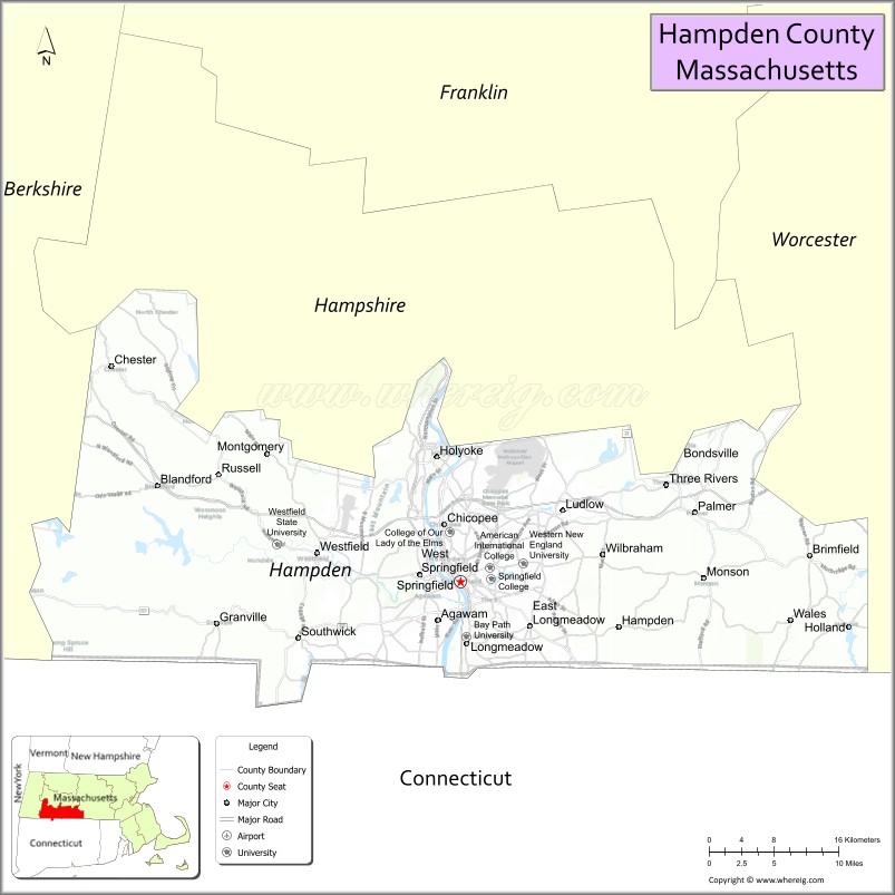
About Hampden County Map, Massachusetts: The map showing the county boundary, county seat, major cities, highways, water bodies and neighbouring counties.
Other Massachusetts Maps & Info
Map of Hampden County, Massachusetts
Hampden County is a county located in the U.S. state of Massachusetts. It's county seat is Springfield. As per 2020 census, the population of Hampden County is 462718 people and population density is square miles. According to the United States Census Bureau, the county has a total area of 618 sq mi (1,601 km2). Hampden County was established on 1812.
Hampden County Facts
| Continent | North America |
| Country | United States |
| State | Massachusetts |
| County Seat | Springfield |
| Largest City/Town | Springfield |
| Established | 1812 |
| Total Area | 634 sq mi |
| Land Area | 617 sq mi |
| Water Area | 17 sq mi |
| Population | 466,372 (Census 2020) |
| Population Density | 756 people per sq mi |
| Time Zone | Eastern Time Zone (ET) |
| Major Highways | I-90, I-91, I-291, I-391, US-5, US-20, MA-57 |
| Neighboring Counties | Hampshire County, Franklin County, Worcester County, Hartford County (CT), Tolland County (CT) |
| Famous For | Springfield Armory, Basketball Hall of Fame, Connecticut River Valley |
| Top Attractions | Naismith Memorial Basketball Hall of Fame, Six Flags New England, Springfield Museums |
| Official Website | https://www.sec.state.ma.us/cis/cisham/hampidx.htm |
Ctities in Hampden county
| City Name | Type | Population (2020) | Pop. Density | Area | Incorporated |
|---|---|---|---|---|---|
| Agawam | City[a] | 28,692 | 24.3 sq mi (62.94 km2) sq mi | 1855 | |
| Blandford | Town | 1,215 | 53.4 sq mi (138.31 km2) sq mi | 1741 | |
| Brimfield | Town | 3,694 | 35.2 sq mi (91.17 km2) sq mi | 1731 | |
| Chester | Town | 1,228 | 37.2 sq mi (96.35 km2) sq mi | 1765 | |
| Chicopee | City | 55,560 | 23.9 sq mi (61.90 km2) sq mi | 1848 | |
| East Longmeadow | City | 16,430 | 13.0 sq mi (33.67 km2) sq mi | 1894 | |
| Granville | Town | 1,538 | 43.0 sq mi (111.37 km2) sq mi | 1775 | |
| Hampden | Town | 4,966 | 19.7 sq mi (51.02 km2) sq mi | 1878 | |
| Holland | Town | 2,603 | 13.1 sq mi (33.93 km2) sq mi | 1835 | |
| Holyoke | City | 38,238 | 22.8 sq mi (59.05 km2) sq mi | 1850 | |
| Longmeadow | Town | 15,853 | 9.7 sq mi (25.12 km2) sq mi | 1783 | |
| Ludlow | Town | 21,002 | 28.2 sq mi (73.04 km2) sq mi | 1775 | |
| Monson | Town | 8,150 | 44.8 sq mi (116.03 km2) sq mi | 1775 | |
| Montgomery | Town | 819 | 15.2 sq mi (39.37 km2) sq mi | 1780 | |
| Palmer | City[a] | 12,448 | 32.0 sq mi (82.88 km2) sq mi | 1775 | |
| Russell | Town | 1,643 | 17.8 sq mi (46.10 km2) sq mi | 1792 | |
| Southwick | Town | 9,232 | 31.7 sq mi (82.10 km2) sq mi | 1775 | |
| Tolland | Town | 471 | 32.8 sq mi (84.95 km2) sq mi | 1810 | |
| Wales | Town | 1,832 | 15.9 sq mi (41.18 km2) sq mi | 1762 | |
| West Springfield | City[a] | 28,835 | 17.5 sq mi (45.32 km2) sq mi | 1774 | |
| Westfield | City | 40,834 | 47.3 sq mi (122.51 km2) sq mi | 1669 | |
| Wilbraham | Town | 14,613 | 22.4 sq mi (58.02 km2) sq mi | 1763 | |
| Springfield | City | 155,929 | 33.1 sq mi (85.73 km2) sq mi | 1636 |
Roads and Highways in Hampden County, Massachusetts
Hampden County is a transportation hub in western Massachusetts with several major highways connecting it to surrounding states and cities.
- Interstate 90 (Massachusetts Turnpike) – east-west route connecting Boston and Albany, NY
- Interstate 91 – north-south highway linking Vermont, Springfield, and Connecticut
- Interstate 291 – connects I-90 and I-91 through Springfield
- Interstate 391 – connects Holyoke to I-91 and I-90
- U.S. Route 5 – runs along the Connecticut River through major towns
- U.S. Route 20 – crosses the county east-west through Springfield and Westfield
- Massachusetts Route 57 – connects Springfield to western Massachusetts towns
Neighboring Counties of Hampden County
- Hampshire County (north)
- Franklin County (north)
- Worcester County (east)
- Hartford County, CT (south)
- Tolland County, CT (southeast)
Top Attractions in Hampden County, Massachusetts
Hampden County offers a mix of history, entertainment, and cultural sites centered around Springfield and nearby cities.
- Naismith Memorial Basketball Hall of Fame – honors the history of basketball
- Six Flags New England – large amusement park in Agawam with rides and attractions
- Springfield Museums – group of museums covering art, history, and science
- Springfield Armory National Historic Site – birthplace of the U.S. Army’s armory
- Forest Park – large urban park with trails, gardens, and a zoo
- Holyoke Heritage State Park – showcases industrial history along the canal system
- Westfield River Walk – scenic walking paths along the river
- Mount Tom State Reservation – popular for hiking and scenic views
Distance from Hampden County to Nearby Cities
- Springfield to Boston – 90 mi (145 km)
- Springfield to Hartford – 25 mi (40 km)
- Springfield to Albany – 85 mi (137 km)
- Springfield to New York City – 140 mi (225 km)
- Springfield to Worcester – 50 mi (80 km)
FAQs about Hampden County
Hampden County is located in western Massachusetts along the Connecticut River and borders Connecticut.
It is known for Springfield, the birthplace of basketball, and attractions like the Basketball Hall of Fame.
Springfield is the largest city and serves as the county seat.
Yes, it is served by major highways like I-90 and I-91, making it a key travel route in the region.
Main highways include I-90, I-91, and U.S. Route 20, connecting the county to nearby states and cities.
- Alabama Counties
- Alaska boroughs
- Arizona Counties
- Arkansas Counties
- California County Map
- Colorado Counties
- Connecticut Counties
- Delaware Counties
- Florida County Map
- Georgia County Map
- Hawaii Counties
- Idaho Counties
- Illinois Counties
- Indiana Counties
- Iowa Counties
- Kansas Counties
- Kentucky Counties
- Louisiana Counties
- Maine Counties
- Maryland Counties
- Massachusetts Counties
- Michigan County Map
- Minnesota Counties
- Mississippi Counties
- Missouri Counties
- Montana Counties
- Nebraska Counties
- Nevada Counties
- New York Counties
- New Hampshire Counties
- New Jersey Counties
- New Mexico Counties
- North Carolina Counties
- North Dakota Counties
- Ohio County Map
- Oklahoma Counties
- Oregon Counties
- Pennsylvania Counties
- Rhode Island Counties
- South Carolina Counties
- South Dakota Counties
- Map of Tennessee
- Texas County Map
- Utah Counties
- Vermont Counties
- Virginia Counties
- Washington Counties
- West Virginia Counties
- Wisconsin Counties
- Wyoming Counties
Written and fact-checked by Whereig.com Web Team | Last Updated: January 27, 2025, 12:15 PM ET