Map of Norfolk County - Norfolk County is a county located in the U.S. state of Massachusetts. Norfolk County Map showing cities, highways, important places and water bodies. Get Where is Norfolk County located in the map, major cities in Norfolk county, population, areas, and places of interest.
Map of Norfolk County, Massachusetts
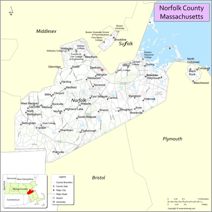
About Norfolk County Map, Massachusetts: The map showing the county boundary, county seat, major cities, highways, water bodies and neighbouring counties.
Other Massachusetts Maps & Info
Map of Norfolk County, Massachusetts
Norfolk County is a county located in the U.S. state of Massachusetts. It's county seat is Dedham. As per 2020 census, the population of Norfolk County is 724505 people and population density is square miles. According to the United States Census Bureau, the county has a total area of 400 sq mi (1,036 km2). Norfolk County was established on 1793.
Norfolk County Facts
| Continent | North America |
| Country | United States |
| State | Massachusetts |
| County Seat | Dedham |
| Largest City/Town | Quincy |
| Established | 1793 |
| Total Area | 443 sq mi |
| Land Area | 396 sq mi |
| Water Area | 47 sq mi |
| Population | 725,981 (Census 2020) |
| Population Density | 1,834 people per sq mi |
| Time Zone | Eastern Time Zone (ET) |
| Major Highways | I-95, I-93, I-495, US-1, MA-3, MA-128 |
| Neighboring Counties | Suffolk County, Middlesex County, Bristol County, Plymouth County, Worcester County |
| Famous For | Historic Quincy, suburban Boston communities, Blue Hills Reservation |
| Top Attractions | Adams National Historical Park, Blue Hills Reservation, Wrentham Village Premium Outlets |
| Official Website | https://www.sec.state.ma.us/cis/cisnor/noridx.htm |
Ctities in Norfolk county
| City Name | Type | Population (2020) | Pop. Density | Area | Incorporated |
|---|---|---|---|---|---|
| Avon | Town | 4,777 | 4.6 sq mi (11.91 km2) sq mi | 1888 | |
| Bellingham | Town | 16,945 | 19.0 sq mi (49.21 km2) sq mi | 1719 | |
| Braintree | City[a] | 39,143 | 14.6 sq mi (37.81 km2) sq mi | 1640 | |
| Brookline | Town | 63,191 | 6.8 sq mi (17.61 km2) sq mi | 1705 | |
| Canton | Town | 24,370 | 19.6 sq mi (50.76 km2) sq mi | 1797 | |
| Cohasset | Town | 8,381 | 31.4 sq mi (81.33 km2) sq mi | 1775 | |
| Dover | Town | 5,923 | 15.4 sq mi (39.89 km2) sq mi | 1836 | |
| Foxborough | Town | 18,618 | 20.9 sq mi (54.13 km2) sq mi | 1778 | |
| Franklin | City[a] | 33,261 | 27.0 sq mi (69.93 km2) sq mi | 1778 | |
| Holbrook | Town | 11,405 | 7.4 sq mi (19.17 km2) sq mi | 1872 | |
| Medfield | Town | 12,799 | 14.6 sq mi (37.81 km2) sq mi | 1651 | |
| Medway | Town | 13,115 | 11.5 sq mi (29.78 km2) sq mi | 1713 | |
| Millis | Town | 8,460 | 12.3 sq mi (31.86 km2) sq mi | 1885 | |
| Milton | Town | 28,630 | 13.3 sq mi (34.45 km2) sq mi | 1662 | |
| Needham | Town | 32,091 | 12.7 sq mi (32.89 km2) sq mi | 1711 | |
| Norfolk | Town | 11,662 | 15.2 sq mi (39.37 km2) sq mi | 1870 | |
| Norwood | Town | 31,611 | 10.6 sq mi (27.45 km2) sq mi | 1872 | |
| Plainville | Town | 9,945 | 11.5 sq mi (29.78 km2) sq mi | 1905 | |
| Quincy | City | 101,636 | 26.9 sq mi (69.67 km2) sq mi | 1792 | |
| Randolph | City[a] | 34,984 | 10.5 sq mi (27.19 km2) sq mi | 1793 | |
| Sharon | Town | 18,575 | 24.2 sq mi (62.68 km2) sq mi | 1775 | |
| Stoughton | Town | 29,281 | 16.3 sq mi (42.22 km2) sq mi | 1726 | |
| Walpole | Town | 26,383 | 21.0 sq mi (54.39 km2) sq mi | 1724 | |
| Wellesley | Town | 29,550 | 10.5 sq mi (27.19 km2) sq mi | 1881 | |
| Westwood | Town | 16,266 | 11.1 sq mi (28.75 km2) sq mi | 1897 | |
| Weymouth | City[a] | 57,437 | 21.6 sq mi (55.94 km2) sq mi | 1635 | |
| Wrentham | Town | 12,178 | 22.9 sq mi (59.31 km2) sq mi | 1673 | |
| Dedham | Town | 25,364 | 10.6 sq mi (27.45 km2) sq mi | 1636 |
Roads and Highways in Norfolk County, Massachusetts
Norfolk County is well connected by major highways that link suburban communities to Boston and surrounding regions.
- Interstate 95 – major beltway connecting multiple suburbs around Boston
- Interstate 93 – connects Quincy and other areas directly to Boston
- Interstate 495 – outer loop linking Norfolk County to broader Massachusetts regions
- U.S. Route 1 – runs parallel to I-95 through several towns
- Massachusetts Route 3 – connects Quincy to the South Shore and Cape Cod
- Massachusetts Route 128 – part of the I-95 beltway through the county
Neighboring Counties of Norfolk County
- Suffolk County (north)
- Middlesex County (northwest)
- Worcester County (west)
- Bristol County (southwest)
- Plymouth County (southeast)
Top Attractions in Norfolk County, Massachusetts
Norfolk County offers a mix of historical sites, natural areas, and shopping destinations near the Boston metro area.
- Adams National Historical Park – historic homes of Presidents John Adams and John Quincy Adams
- Blue Hills Reservation – large natural area with hiking trails and scenic views
- Wrentham Village Premium Outlets – popular shopping destination with many brands
- Quincy Quarries Reservation – unique park with rock formations and climbing areas
- Brookline Village – charming area with shops, restaurants, and historic buildings
- Stony Brook Wildlife Sanctuary – peaceful nature preserve with walking trails
- Houghton’s Pond – popular swimming and picnic area in Blue Hills
- F1 Boston (Entertainment Center) – indoor karting and activities in Braintree
Distance from Norfolk County to Nearby Cities
- Quincy to Boston – 10 mi (16 km)
- Dedham to Providence – 35 mi (56 km)
- Weymouth to Plymouth – 30 mi (48 km)
- Quincy to Worcester – 45 mi (72 km)
- Brookline to Hartford – 95 mi (153 km)
FAQs about Norfolk County
Norfolk County is located in eastern Massachusetts, just southwest of Boston.
It is known for historic sites in Quincy, suburban communities, and natural areas like Blue Hills Reservation.
Quincy is the largest city in Norfolk County.
Yes, much of the county is part of the Greater Boston metropolitan area.
Main highways include I-95, I-93, I-495, and U.S. Route 1.
- Alabama Counties
- Alaska boroughs
- Arizona Counties
- Arkansas Counties
- California County Map
- Colorado Counties
- Connecticut Counties
- Delaware Counties
- Florida County Map
- Georgia County Map
- Hawaii Counties
- Idaho Counties
- Illinois Counties
- Indiana Counties
- Iowa Counties
- Kansas Counties
- Kentucky Counties
- Louisiana Counties
- Maine Counties
- Maryland Counties
- Massachusetts Counties
- Michigan County Map
- Minnesota Counties
- Mississippi Counties
- Missouri Counties
- Montana Counties
- Nebraska Counties
- Nevada Counties
- New York Counties
- New Hampshire Counties
- New Jersey Counties
- New Mexico Counties
- North Carolina Counties
- North Dakota Counties
- Ohio County Map
- Oklahoma Counties
- Oregon Counties
- Pennsylvania Counties
- Rhode Island Counties
- South Carolina Counties
- South Dakota Counties
- Map of Tennessee
- Texas County Map
- Utah Counties
- Vermont Counties
- Virginia Counties
- Washington Counties
- West Virginia Counties
- Wisconsin Counties
- Wyoming Counties
Written and fact-checked by Whereig.com Web Team | Last Updated: January 27, 2025, 12:15 PM ET