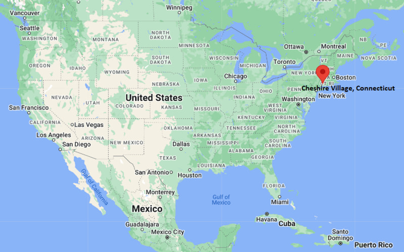
Where is Cheshire Village Located? - Cheshire Village is a city located in the New Haven County of Connecticut, United States. Cheshire Village lies between 26.2379 Degrees North latitudes and 80.1248 Degrees West longitudes.
Location Map of Cheshire Village, Connecticut
Cheshire Village Map, Connecticut, USA
Where is Cheshire Village?: The Google Map showing the location of Cheshire Village in the U.S. state of Connecticut.
Where is Cheshire Village Located?
Cheshire Village is a city located in the New Haven County of Connecticut, United States. Cheshire Village lies between 26.2379 Degrees North latitudes and 80.1248 Degrees West longitudes. According to 2020 U.S.census, the population of Cheshire Village city is 6499 people and the city has a total area of 3.37 sq mi. The city has numerous parks and recreational facilities.
Nearby Amtrak and CTrail stations in Meriden, Wallingford, and New Haven
Local Bus/Transit Service
CTtransit regional bus service
Interstate 691 and Connecticut Routes 10 and 68 provide convenient access to Hartford, Waterbury, and New Haven.
Tweed New Haven Airport is approximately 20 miles south, while Bradley International Airport is about 40 miles north.
Amtrak Hartford Line and CTrail commuter rail services are available from nearby Meriden, Wallingford, and New Haven stations.
CTtransit operates regional bus routes connecting Cheshire Village with neighboring communities.
Cheshire Village is known for its residential neighborhoods, highly rated schools, the Farmington Canal Heritage Trail, and its central location between Hartford and New Haven.
Key Landmarks and Places to Visit in Cheshire Village, Connecticut
Landmark Name
Type
Barker Character, Comic and Cartoon Museum
Specialty Museum
Farmington Canal Heritage Trail
Multi-Use Recreation Trail
Bartlem Recreation Area
Community Park
Roaring Brook Falls
Scenic Waterfall
Sleeping Giant State Park
State Park
Brooksvale Park
Nature Park
Lock 12 Historical Park
Historic Site
Hubbard Park
City Park
West Rock Ridge State Park
State Park
Connecticut Wine Trail (nearby wineries)
Tourist Attraction
Colleges and Universities in and near Cheshire Village, Connecticut
Institution Name
Type
Level
Notable For
Quinnipiac University
Private
University
Medicine, law, business, communications, and health sciences
Southern Connecticut State University
Public
University
Education, nursing, business, and liberal arts
University of New Haven
Private
University
Engineering, criminal justice, business, and cybersecurity
Yale University
Private
University
Research, medicine, law, engineering, and humanities
Naugatuck Valley Community College
Public
Community College
Career education, healthcare, and transfer programs
Waterbodies in Cheshire Village, Connecticut
Mill River, Quinnipiac River, Roaring Brook, Mixville Reservoir, Black Pond, Merimere Reservoir, Lake Whitney, Muddy River
Golf Courses in and near Cheshire Village, Connecticut
Cheshire Country Club, Sleeping Giant Golf Course, Farms Country Club, Hunter Memorial Golf Course, East Mountain Golf Course, Traditions Golf Club at Wallingford, Highland Greens Golf Course, Lyman Orchards Golf Club
Cheshire Village, Connecticut - Key Historical Facts
Cheshire was settled in the late seventeenth century and became a separate town from Wallingford in 1780.
The community earned the nickname "The Bedding Plant Capital of Connecticut" because of its long tradition of horticulture and greenhouse farming.
During the nineteenth century, local industries included agriculture, clock manufacturing, and small-scale manufacturing businesses.
The historic Farmington Canal passed through Cheshire, helping connect the town with markets across Connecticut before later becoming a popular recreational trail.
Steady residential and commercial growth during the twentieth century transformed Cheshire into a desirable suburban community while preserving much of its historic character.
Today, Cheshire Village serves as the commercial and civic center of the town, known for its parks, trails, excellent schools, community events, and convenient location between Hartford and New Haven.