
Where is Wallingford Center Located? - Wallingford Center is a city located in the New Haven County of Connecticut, United States. Wallingford Center lies between 39.1321 Degrees North latitudes and 75.5324 Degrees West longitudes.
Location Map of Wallingford Center, Connecticut
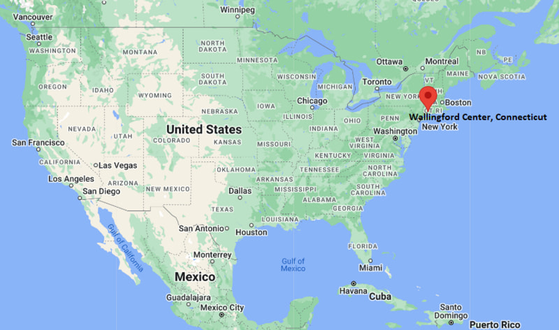
Wallingford Center Map, Connecticut, USA
Where is Wallingford Center?: The Google Map showing the location of Wallingford Center in the U.S. state of Connecticut.
Where is Wallingford Center Located?
Wallingford Center is a city located in the New Haven County of Connecticut, United States. Wallingford Center lies between 39.1321 Degrees North latitudes and 75.5324 Degrees West longitudes. According to 2020 U.S.census, the population of Wallingford Center city is 18278 people and the city has a total area of 7.26 sq mi. The city has numerous parks and recreational facilities.
Most Viewed US Maps
| USA Sttae Map | USA Region Map | USA Road Map |
| USA County Map | Where is USA in World Map? | US ZIP Code Map |
| USA Time Zones Map | US State and Capitals Map | USA Physical Map |
Find 4,400+ U.S. Cities by State - Explore Their Locations and Get Detailed Information
Wallingford Center, Connecticut Quick Facts
| Attribute | Details |
|---|---|
| Community | Wallingford Center |
| County | New Haven County |
| State | Connecticut |
| State Capital | Hartford |
| US Region | New England |
| Latitude | 41.4570° N |
| Longitude | 72.8230° W |
| Elevation | Approximately 148 ft (45 m) |
| Land Area | 7.3 sq mi |
| Water Area | 0.1 sq mi |
| Total Area | 7.4 sq mi |
| Population (2020 Census) | 18,278 |
| Population Density | Approximately 2,500 per sq mi |
| ZIP Code | 06492 |
| Area Codes | 203, 475 |
| Time Zone Standard | Eastern Standard Time (EST), UTC−5 |
| Time Zone Daylight | Eastern Daylight Time (EDT), UTC−4 |
| Currency | United States Dollar (USD) |
| FIPS Code | 09-78880 |
| Community Type | Census-designated place (CDP) |
Transportation and Connectivity in Wallingford Center, Connecticut
| Transportation | Details |
|---|---|
| Nearest Airport | Tweed New Haven Airport |
| IATA Code | HVN |
| Regional Airport | Bradley International Airport |
| Major Highways | Interstate 91, US Route 5, Connecticut Route 15, Route 68, Route 71, Route 150 |
| Rail Service | Wallingford Station provides CTrail Hartford Line and Amtrak service |
| Bus Service | CTtransit provides regional bus service between Wallingford, Meriden, and New Haven |
| Local Connectivity | Central Connecticut location with convenient access to New Haven, Meriden, Hartford, and surrounding communities |
- Interstate 91 — Major north-south interstate connecting Wallingford Center with New Haven, Hartford, and other communities in the Connecticut River Valley.
- US Route 5 — Historic north-south route passing through the Wallingford area and connecting local commercial districts.
- Connecticut Route 15 — Wilbur Cross Parkway provides regional access toward New Haven and other parts of southern Connecticut.
Top Places to Visit in Wallingford Center, Connecticut
| Landmark Name | Type |
|---|---|
| Wallingford Historic District | Historic District |
| Wallingford Center Historic District | Historic Area |
| Paul Mellon Arts Center | Cultural Center |
| Quinnipiac River Linear Trail | Recreation Trail |
| Wallingford Public Library | Cultural Facility |
| Gouveia Vineyards | Vineyard |
| Wharton Brook State Park | State Park |
| Yale University Art Gallery | Art Museum |
| Sleeping Giant State Park | State Park |
| Quinnipiac University | University Campus |
Driving Distances from Wallingford Center, Connecticut to Nearby Cities
| City | State | Distance (mi) | Approx. Drive Time |
|---|---|---|---|
| Meriden | Connecticut | 7 mi | 15 minutes |
| New Haven | Connecticut | 13 mi | 20 minutes |
| Hamden | Connecticut | 10 mi | 15 minutes |
| Cheshire | Connecticut | 9 mi | 15 minutes |
| Hartford | Connecticut | 30 mi | 35 minutes |
| Bridgeport | Connecticut | 35 mi | 45 minutes |
| Stamford | Connecticut | 65 mi | 1 hour 10 minutes |
| Danbury | Connecticut | 45 mi | 55 minutes |
| Springfield | Massachusetts | 55 mi | 1 hour |
| New York City | New York | 90 mi | 1 hour 45 minutes |
Colleges and Universities Near Wallingford Center, Connecticut
| Institution Name | Type | Level | Notable For |
|---|---|---|---|
| Quinnipiac University | Private | University | Business, health sciences, law, communications, and liberal arts |
| Yale University | Private | University | Law, medicine, arts, sciences, humanities, and research |
| Gateway Community College | Public | Community College | Healthcare, technology, business, liberal arts, and workforce programs |
| Albertus Magnus College | Private | College | Liberal arts, business, education, and professional studies |
| University of New Haven | Private | University | Engineering, business, criminal justice, health sciences, and technology |
Waterbodies Near Wallingford Center, Connecticut
Quinnipiac River, Wharton Brook, Community Lake, Pistapaug Pond, and nearby reservoirs and streams provide opportunities for fishing, kayaking, hiking, wildlife viewing, and outdoor recreation.
Golf Courses and Stadiums Near Wallingford Center
Golf Courses: Tradition Golf Club at Wallingford, Wallingford Country Club, and Sleeping Giant Golf Course. Stadiums and sports facilities include Sheehan High School athletic facilities, Lyman Hall High School athletic facilities, and nearby Quinnipiac University sports facilities.
Key Landmarks and Places to Visit in Wallingford Center, Connecticut
| Landmark Name | Type |
|---|---|
| Wallingford Center Historic District | Historic District |
| Paul Mellon Arts Center | Cultural Center |
| Gouveia Vineyards | Vineyard |
| Wharton Brook State Park | State Park |
| Quinnipiac River Linear Trail | Recreation Trail |
| Wallingford Public Library | Cultural Facility |
| Wallingford Railroad Station | Historic Transportation Site |
| Quinnipiac University | University Campus |
| Sleeping Giant State Park | State Park |
| Wallingford Town Green | Public Green |
Wallingford Center, Connecticut — Key Historical Facts
- The Wallingford area was originally inhabited by Native American peoples, including groups associated with the Quinnipiac and Mattabesett regions.
- English settlers established Wallingford in the 17th century, and the town was incorporated in 1670.
- The community developed around agriculture, mills, and small industries supported by the Quinnipiac River and local waterways.
- Wallingford became known for manufacturing, including metalworking, silverware, and other industrial products.
- The arrival of the railroad in the 19th century strengthened Wallingford's connections with New Haven, Hartford, and other Connecticut communities.
- The town's historic center retains buildings and streetscapes that reflect its colonial, industrial, and civic development.
- Wallingford later developed into a suburban community while retaining manufacturing, commercial, educational, and cultural institutions.
- Today, Wallingford Center is known for its historic downtown, parks, trails, educational institutions, vineyards, and convenient location between New Haven and Hartford.
References
- United States Census Bureau
- Town of Wallingford Official Website
- State of Connecticut Official Website
- Connecticut Department of Energy and Environmental Protection
- Connecticut Tourism
Connecticut Maps and Info
- Where is Ansonia
- Where is Bethel
- Where is Bridgeport
- Where is Bristol
- Where is Cheshire Village
- Where is Cos Cob
- Where is Danbury
- Where is Derby
- Where is East Hartford
- Where is East Haven
- Where is Glastonbury Center
- Where is Greenwich
- Where is Groton
- Where is Hartford
- Where is Hazardville
- Where is Kensington
- Where is Manchester
- Where is Meriden
- Where is Middletown
- Where is Milford
- Where is Naugatuck
- Where is New Britain
- Where is New Haven
- Where is New London
- Where is New Milford
- Where is Newington
- Where is North Haven
- Where is Norwalk
- Where is Norwich
- Where is Oakville
- Where is Old Greenwich
- Where is Orange
- Where is Putnam
- Where is Ridgefield
- Where is Rockville
- Where is Shelton
- Where is Southwood Acres
- Where is Stamford
- Where is Storrs
- Where is Thompsonville
- Where is Torrington
- Where is Wallingford Center
- Where is Waterbury
- Where is West Hartford
- Where is West Haven
- Where is Wethersfield
- Where is Willimantic
- Where is Windsor Locks
- Where is Winsted