
Where is Bethel Located? - Bethel is a city located in the Anoka County of Connecticut, United States. Bethel lies between 41.3813 Degrees North latitudes and -73.4008 Degrees West longitudes.
Location Map of Bethel, Connecticut
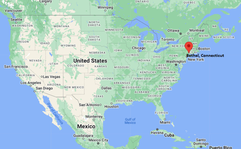
Bethel Map, Connecticut, USA
Where is Bethel?: The Google Map showing the location of Bethel in the U.S. state of Connecticut.
Where is Bethel Located?
Bethel is a census-designated place located in Fairfield County of Connecticut, United States. Bethel lies between 41.3813 Degrees North latitude and -73.4008 Degrees West longitude. According to the 2020 U.S. Census, the population of Bethel CDP is 11,582 people and the CDP has a total area of 4.09 sq mi. The CDP has numerous parks and recreational facilities.
Most Viewed US Maps
| USA Sttae Map | USA Region Map | USA Road Map |
| USA County Map | Where is USA in World Map? | US ZIP Code Map |
| USA Time Zones Map | US State and Capitals Map | USA Physical Map |
Find 4,400+ U.S. Cities by State - Explore Their Locations and Get Detailed Information
Bethel, Connecticut Quick Facts
| Fact | Details |
|---|---|
| Town | Bethel |
| County | Fairfield County |
| State | Connecticut |
| State Capital | Hartford |
| Country | United States |
| US Region | Northeast |
| Latitude | 41.3813 N |
| Longitude | -73.4008 W |
| Elevation | 351 ft (107 m) |
| Land Area | 16.88 sq mi |
| Water Area | 0.24 sq mi |
| Total Area | 4.09 sq mi |
| Population (Census 2020) | 20,358 |
| Population Density | Approximately 1,206 per sq mi |
| ZIP Code | 06801 |
| Area Code | 203, 475 |
| Time Zone Standard | Eastern Standard Time (EST, UTC-5) |
| Time Zone Daylight | Eastern Daylight Time (EDT, UTC-4) |
| Currency | United States Dollar (USD) |
| FIPS Code | 09-04310 |
| Congressional District | Connecticut's 5th Congressional District |
Nearby Cities and Towns to Bethel, Connecticut
- Danbury, Connecticut - 3 mi West
- Brookfield, Connecticut - 5 mi North
- Redding, Connecticut - 7 mi Southeast
- Newtown, Connecticut - 8 mi East
- Ridgefield, Connecticut - 9 mi Southwest
- New Fairfield, Connecticut - 10 mi North
- New Milford, Connecticut - 17 mi North
- Wilton, Connecticut - 18 mi South
- Norwalk, Connecticut - 24 mi South
- Waterbury, Connecticut - 31 mi Northeast
Bethel, Connecticut Climate and Weather Overview
| Month | Avg High (°F) | Avg Low (°F) | Avg Rainfall (in) |
|---|---|---|---|
| January | 37 | 20 | 3.7 |
| April | 60 | 39 | 4.3 |
| July | 84 | 64 | 4.5 |
| October | 64 | 44 | 4.2 |
| Annual | 61 | 42 | 50.0 |
| Climate Attribute | Details |
|---|---|
| Climate Classification | Humid Continental (Köppen Dfa) |
| Annual Rainfall | Approximately 50 inches |
| Annual Sunshine Days | About 201 days |
| Hurricane/Tornado Risk | Low - Occasional tropical storms, winter snowstorms and thunderstorms |
| Snowfall | Approximately 37 inches annually |
Driving Distances from Bethel, Connecticut
| City | State | Distance (mi) | Approx. Drive Time |
|---|---|---|---|
| Danbury | Connecticut | 3 | 8 min |
| Brookfield | Connecticut | 5 | 10 min |
| Redding | Connecticut | 7 | 15 min |
| Newtown | Connecticut | 8 | 15 min |
| Ridgefield | Connecticut | 9 | 18 min |
| New Fairfield | Connecticut | 10 | 18 min |
| New Milford | Connecticut | 17 | 25 min |
| Wilton | Connecticut | 18 | 28 min |
| Norwalk | Connecticut | 24 | 35 min |
| Waterbury | Connecticut | 31 | 40 min |
Transportation and Connectivity in Bethel, Connecticut
| Transportation | Details |
|---|---|
| Airport Name | Westchester County Airport (nearest major airport) |
| IATA Code | HPN |
| Port | Port of Bridgeport (regional) |
| Major Highways | U.S. Route 6, Connecticut Route 53, Connecticut Route 302, Interstate 84 (nearby) |
| Train/Metro Service | Metro-North Railroad Danbury Branch (Bethel Station) |
| Local Bus/Transit Service | HARTransit bus service |
- Interstate 84 - Located just south of Bethel, providing convenient access to Danbury, Waterbury and Hartford.
- U.S. Route 6 - A major east-west highway connecting Bethel with neighboring towns across western Connecticut.
- Metro-North Railroad - Bethel Station on the Danbury Branch offers commuter rail service to South Norwalk with connections to New York City.
- Westchester County Airport - Approximately 35 miles southwest of Bethel, providing regional commercial air service.
Key Landmarks and Places to Visit in Bethel, Connecticut
| Landmark | Type |
|---|---|
| P.T. Barnum Square | Historic Town Center |
| Meckauer Park | Community Park |
| Huntington State Park | State Park |
| Putnam Memorial State Park | Historic State Park |
| Bethel Historical Society Museum | History Museum |
| Danbury Railway Museum | Railroad Museum |
| Tarrywile Park & Mansion | Nature Preserve |
| Ives Concert Park | Outdoor Performance Venue |
| Collis P. Huntington State Park | State Park |
| Candlewood Lake | Recreation Area |
Colleges and Universities in Bethel, Connecticut
| Institution | Type | Level | Notable For |
|---|---|---|---|
| Western Connecticut State University | Public | University | Business, education and liberal arts |
| Naugatuck Valley Community College - Danbury Campus | Public | Community College | Workforce and transfer programs |
| Sacred Heart University | Private | University | Health sciences and business |
| Fairfield University | Private | University | Liberal arts, engineering and management |
| University of Bridgeport | Private | University | Professional and graduate education |
| Housatonic Community College | Public | Community College | Associate degrees and technical education |
Waterbodies in Bethel, Connecticut
Still River, Candlewood Lake, Lake Lillinonah, Housatonic River, Limekiln Brook, Sympaug Brook, Ball Pond, Squantz Pond, Lake Zoar, Beaver Brook.
Golf Courses in Bethel, Connecticut
Redding Country Club, Richter Park Golf Course, Sunset Hill Golf Club, Brookfield Golf Course, Ridgewood Country Club, The Golf Club at Oxford Greens, Candlewood Valley Country Club, Heritage Village Country Club.
Bethel, Connecticut - Key Historical Facts
- Bethel was originally part of the Town of Danbury before becoming an independent town in 1855.
- During the nineteenth century, the community became known for manufacturing hats, carriages and other industrial products that contributed to the local economy.
- The arrival of the railroad encouraged commercial growth and strengthened Bethel's connections with nearby cities, including Danbury and New York.
- P.T. Barnum, the famous showman, was born in Bethel in 1810, and the town honors his legacy through landmarks and historical sites.
- Over time, Bethel evolved into a desirable residential community while preserving its historic downtown and New England character.
- Today, Bethel is recognized for its vibrant Main Street, historic architecture, parks, cultural events and convenient access to the greater Danbury area.
References
Connecticut Maps and Info
- Where is Ansonia
- Where is Bethel
- Where is Bridgeport
- Where is Bristol
- Where is Cheshire Village
- Where is Cos Cob
- Where is Danbury
- Where is Derby
- Where is East Hartford
- Where is East Haven
- Where is Glastonbury Center
- Where is Greenwich
- Where is Groton
- Where is Hartford
- Where is Hazardville
- Where is Kensington
- Where is Manchester
- Where is Meriden
- Where is Middletown
- Where is Milford
- Where is Naugatuck
- Where is New Britain
- Where is New Haven
- Where is New London
- Where is New Milford
- Where is Newington
- Where is North Haven
- Where is Norwalk
- Where is Norwich
- Where is Oakville
- Where is Old Greenwich
- Where is Orange
- Where is Putnam
- Where is Ridgefield
- Where is Rockville
- Where is Shelton
- Where is Southwood Acres
- Where is Stamford
- Where is Storrs
- Where is Thompsonville
- Where is Torrington
- Where is Wallingford Center
- Where is Waterbury
- Where is West Hartford
- Where is West Haven
- Where is Wethersfield
- Where is Willimantic
- Where is Windsor Locks
- Where is Winsted