
Where is New Milford Located? - New Milford is a city located in the Bergen County of Connecticut, United States. New Milford lies between 26.6253 Degrees North latitudes and 81.6248 Degrees West longitudes.
Location Map of New Milford, Connecticut
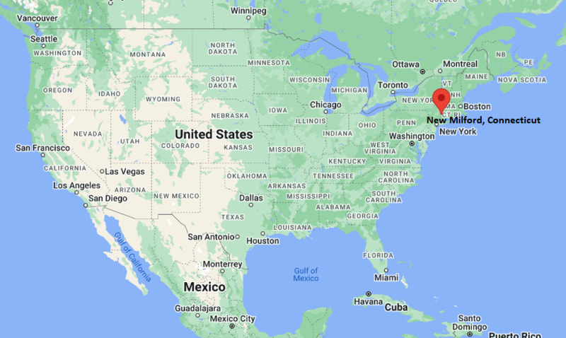
New Milford Map, Connecticut, USA
Where is New Milford?: The Google Map showing the location of New Milford in the U.S. state of Connecticut.
Where is New Milford Located?
New Milford is a city located in the Bergen County of New Jersey, United States. New Milford lies between 26.6253 Degrees North latitudes and 81.6248 Degrees West longitudes. According to 2020 U.S.census, the population of New Milford city is 7160 people and the city has a total area of 3.41 sq mi. The city has numerous parks and recreational facilities.
Most Viewed US Maps
| USA Sttae Map | USA Region Map | USA Road Map |
| USA County Map | Where is USA in World Map? | US ZIP Code Map |
| USA Time Zones Map | US State and Capitals Map | USA Physical Map |
Find 4,400+ U.S. Cities by State - Explore Their Locations and Get Detailed Information
New Milford, Connecticut Quick Facts
| Attribute | Information |
|---|---|
| City | New Milford |
| County | Litchfield County |
| State | Connecticut |
| State Capital | Hartford |
| US Region | Northeast (New England) |
| Latitude | 41.5770° N |
| Longitude | 73.4087° W |
| Elevation | 312 ft (95 m) |
| Land Area | 61.7 sq mi |
| Water Area | 3.5 sq mi |
| Total Area | 65.2 sq mi |
| Population (2020 Census) | 28,115 |
| Population Density | Approximately 456 per sq mi |
| ZIP Codes | 06755, 06776 |
| Area Code | 860 |
| Time Zone Standard | Eastern Standard Time (EST, UTC−5) |
| Time Zone Daylight | Eastern Daylight Time (EDT, UTC−4) |
| Currency | United States Dollar (USD) |
| FIPS Code | 09-52000 |
| Congressional District | Connecticut's 5th Congressional District |
Transportation and Connectivity in New Milford
| Category | Information |
|---|---|
| Airport Name | Danbury Municipal Airport |
| IATA Code | DXR |
| Nearest Major Airport | Bradley International Airport |
| Major Highways | U.S. Route 7, U.S. Route 202, Connecticut Route 67, Connecticut Route 109 |
| Rail Service | Metro-North Railroad connections available nearby |
| Public Transit | Local and regional bus services |
| Regional Connections | Access to western Connecticut and Hudson Valley region |
- U.S. Route 7 connects New Milford with Danbury and northern Litchfield County communities.
- U.S. Route 202 provides east–west access through western Connecticut.
- Connecticut Route 67 links New Milford with nearby towns and regional destinations.
- Nearby Metro-North Railroad stations provide commuter connections toward New York City.
Top Places to Visit in New Milford, Connecticut
| Landmark Name | Type |
|---|---|
| Harrybrooke Park | Nature Park |
| Grove Street Historic District | Historic District |
| Elephant's Trunk Flea Market | Market Attraction |
| New Milford Green | Historic Town Green |
| Lake Candlewood | Lake Recreation Area |
| Rocky River | River Recreation Area |
| Housatonic River | River Recreation Area |
| Mine Hill Preserve | Nature Preserve |
| Old Town Hall Museum | History Museum |
| Housatonic Railroad Trail | Outdoor Recreation Trail |
Driving Distances from New Milford, Connecticut to Nearby Cities
| City | State | Distance (mi) | Approx. Drive Time |
|---|---|---|---|
| Danbury | Connecticut | 20 | 30 minutes |
| Waterbury | Connecticut | 35 | 45 minutes |
| Bridgeport | Connecticut | 55 | 1 hour |
| Hartford | Connecticut | 60 | 1 hour 15 minutes |
| New Haven | Connecticut | 55 | 1 hour 15 minutes |
| Poughkeepsie | New York | 45 | 1 hour |
| New York City | New York | 85 | 2 hours |
| Albany | New York | 100 | 2 hours |
| Springfield | Massachusetts | 85 | 1 hour 45 minutes |
| Boston | Massachusetts | 150 | 3 hours |
Colleges and Universities Near New Milford, Connecticut
| Institution Name | Type | Level | Notable For |
|---|---|---|---|
| Western Connecticut State University | Public | University | Business, education, arts, sciences, and professional programs |
| Northwestern Connecticut Community College | Public | Community College | Associate degrees, workforce training, and technical programs |
| Connecticut State Community College – Naugatuck Valley | Public | Community College | Career education and transfer programs |
| University of Connecticut – Waterbury Campus | Public | University Campus | Business, education, and undergraduate programs |
| Fairfield University | Private | University | Business, arts, sciences, and professional studies |
Waterbodies Near New Milford, Connecticut
Candlewood Lake, Housatonic River, Still River, Lake Lillinonah, and nearby waterways of northwestern Connecticut.
Stadiums and Sports Facilities in New Milford
New Milford High School athletic facilities, Young's Field at Young's Field Park, Harrybrooke Park recreation areas, and local community sports facilities.
New Milford, Connecticut — Key Historical Facts
- New Milford was settled in 1707 by colonists from Milford, Connecticut, and was incorporated as a town in 1712.
- The town developed along the Housatonic River, which supported early agriculture, trade, and industry.
- New Milford became an important regional center for farming, manufacturing, and commerce in northwestern Connecticut.
- The town's historic green and surrounding buildings reflect its colonial-era development.
- The creation of Candlewood Lake in the twentieth century transformed the area into a major recreation destination.
- Today, New Milford is recognized for its historic downtown, scenic landscapes, outdoor recreation, cultural events, and Housatonic River setting.
References
- Town of New Milford
- Litchfield County Resources
- U.S. Census Bureau
- Visit Connecticut Tourism
- Connecticut Department of Energy and Environmental Protection
Connecticut Maps and Info
- Where is Ansonia
- Where is Bethel
- Where is Bridgeport
- Where is Bristol
- Where is Cheshire Village
- Where is Cos Cob
- Where is Danbury
- Where is Derby
- Where is East Hartford
- Where is East Haven
- Where is Glastonbury Center
- Where is Greenwich
- Where is Groton
- Where is Hartford
- Where is Hazardville
- Where is Kensington
- Where is Manchester
- Where is Meriden
- Where is Middletown
- Where is Milford
- Where is Naugatuck
- Where is New Britain
- Where is New Haven
- Where is New London
- Where is New Milford
- Where is Newington
- Where is North Haven
- Where is Norwalk
- Where is Norwich
- Where is Oakville
- Where is Old Greenwich
- Where is Orange
- Where is Putnam
- Where is Ridgefield
- Where is Rockville
- Where is Shelton
- Where is Southwood Acres
- Where is Stamford
- Where is Storrs
- Where is Thompsonville
- Where is Torrington
- Where is Wallingford Center
- Where is Waterbury
- Where is West Hartford
- Where is West Haven
- Where is Wethersfield
- Where is Willimantic
- Where is Windsor Locks
- Where is Winsted