
Where is Kensington Located? - Kensington is a city located in the Douglas County of Connecticut, United States. Kensington lies between 30.4383 Degrees North latitudes and 84.2807 Degrees West longitudes.
Location Map of Kensington, Connecticut
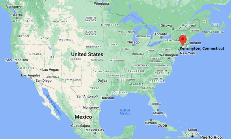
Kensington Map, Connecticut, USA
Where is Kensington?: The Google Map showing the location of Kensington in the U.S. state of Connecticut.
Where is Kensington Located?
Kensington is a city located in the Douglas County of Connecticut, United States. Kensington lies between 30.4383 Degrees North latitudes and 84.2807 Degrees West longitudes. According to 2020 U.S.census, the population of Kensington city is 9962 people and the city has a total area of 5.23 sq mi. The city has numerous parks and recreational facilities.
Most Viewed US Maps
| USA Sttae Map | USA Region Map | USA Road Map |
| USA County Map | Where is USA in World Map? | US ZIP Code Map |
| USA Time Zones Map | US State and Capitals Map | USA Physical Map |
Find 4,400+ U.S. Cities by State - Explore Their Locations and Get Detailed Information
Kensington, Connecticut Quick Facts
| Property | Information |
|---|---|
| Community | Kensington (Census-Designated Place) |
| Town | Berlin |
| County | Hartford County |
| State | Connecticut |
| State Capital | Hartford |
| US Region | Northeastern United States |
| Latitude | 41.6353° N |
| Longitude | 72.7703° W |
| Elevation | 174 ft (53 m) |
| Land Area | 5.44 sq mi |
| Water Area | 0.05 sq mi |
| Total Area | 5.49 sq mi |
| Population (latest Census year) | 8,459 (2020 Census) |
| Population Density | Approximately 1,555 per sq mi |
| ZIP Code | 06037 |
| Area Code | 860, 959 |
| Time Zone Standard | Eastern Standard Time (EST, UTC−5) |
| Time Zone Daylight | Eastern Daylight Time (EDT, UTC−4) |
| Currency | US Dollar (USD) |
| FIPS Code | 09-39410 (CDP) |
| Congressional District | Connecticut's 1st Congressional District |
Nearby Cities to Kensington, Connecticut
- New Britain, Connecticut - North - 4 mi
- Berlin, Connecticut - South - 3 mi
- Newington, Connecticut - Northeast - 6 mi
- Middletown, Connecticut - Southeast - 11 mi
- Meriden, Connecticut - South - 9 mi
- Southington, Connecticut - West - 10 mi
- West Hartford, Connecticut - North - 11 mi
- Hartford, Connecticut - North - 12 mi
- Rocky Hill, Connecticut - East - 7 mi
- Bristol, Connecticut - Northwest - 15 mi
Driving Distances from Kensington, Connecticut
| City | State | Distance (mi) | Approx. Drive Time |
|---|---|---|---|
| Berlin | Connecticut | 3 | 5 minutes |
| New Britain | Connecticut | 4 | 10 minutes |
| Newington | Connecticut | 6 | 12 minutes |
| Rocky Hill | Connecticut | 7 | 12 minutes |
| Meriden | Connecticut | 9 | 15 minutes |
| Southington | Connecticut | 10 | 15 minutes |
| Middletown | Connecticut | 11 | 18 minutes |
| West Hartford | Connecticut | 11 | 20 minutes |
| Hartford | Connecticut | 12 | 20 minutes |
| Bristol | Connecticut | 15 | 25 minutes |
Transportation and Connectivity in Kensington, Connecticut
| Transportation | Details |
|---|---|
| Airport Name | Bradley International Airport |
| IATA Code | BDL |
| Port | No commercial seaport; nearest deep-water port is the Port of New Haven |
| Major Highways | Interstate 84, Interstate 91 (nearby), Connecticut Route 9, U.S. Route 5, Connecticut Route 71 |
| Train/Amtrak Service | CTrail Hartford Line and Amtrak service available at Berlin Station |
| Local Bus/Transit Service | CTtransit Hartford and CTfastrak regional connections |
- Interstate 84 and nearby Interstate 91 provide convenient access to Hartford, Waterbury, Springfield, and New Haven.
- Berlin Station, located just south of Kensington, offers CTrail Hartford Line and Amtrak services connecting New Haven, Hartford, and Springfield.
- CTtransit buses provide regional public transportation to neighboring communities throughout central Connecticut.
- Bradley International Airport, approximately 30 miles north, offers domestic and limited international commercial flights.
- Kensington's central location within the Hartford metropolitan area provides excellent highway and rail connectivity for commuters and visitors.
What are top Places to Visit in Kensington, Connecticut
| Landmark Name | Type |
|---|---|
| Timberlin Golf Club | Golf Course |
| Berlin Historical Society Museum | History Museum |
| Percival Park | Community Park |
| Hatchery Brook Preserve | Nature Preserve |
| Ragged Mountain Memorial Preserve | Nature Preserve |
| Silver Lake | Recreation Area |
| Berlin Fairgrounds | Event Venue |
| Timberlin Park | Public Park |
| Walnut Hill Park | Regional Park |
| New Britain Museum of American Art | Art Museum |
Colleges and Universities in Kensington, Connecticut
| Institution Name | Type | Level | Notable For |
|---|---|---|---|
| Central Connecticut State University | Public | University | Business, engineering, education, liberal arts, and graduate programs |
| University of Hartford | Private | University | Engineering, business, performing arts, and health professions |
| Trinity College | Private | Liberal Arts College | Liberal arts, humanities, sciences, and international studies |
| Tunxis Community College | Public | Community College | Associate degrees, workforce development, healthcare, and transfer programs |
| Wesleyan University | Private | University | Liberal arts, sciences, music, and research |
Waterbodies in Kensington, Connecticut
Mattabesset River, Silver Lake, Shuttle Meadow Reservoir, Hatchery Brook, Willow Brook, Metacomet Brook, Connecticut River (nearby), Farmington River (nearby).
Golf Courses in Kensington, Connecticut
Timberlin Golf Club, Shuttle Meadow Country Club, Stanley Golf Course, Tunxis Country Club, Hunter Memorial Golf Course, Indian Hill Country Club.
Kensington, Connecticut — Key Historical Facts
- Kensington developed during the eighteenth century as a village within the Town of Berlin and became known for agriculture and small-scale manufacturing.
- The arrival of the railroad in the nineteenth century improved transportation, encouraging residential growth and commercial development.
- The community became nationally recognized for its thriving brickmaking industry, with Kensington bricks used in numerous buildings throughout New England.
- Kensington has preserved many historic homes, churches, and civic buildings that reflect its colonial and industrial heritage.
- Today, Kensington is a residential and commercial community within the Hartford metropolitan area, offering convenient transportation, parks, and access to nearby educational institutions.
References
- Town of Berlin
- U.S. Census Bureau
- Central Connecticut State University
- Connecticut Department of Energy and Environmental Protection
- Connecticut Office of Tourism
Connecticut Maps and Info
- Where is Ansonia
- Where is Bethel
- Where is Bridgeport
- Where is Bristol
- Where is Cheshire Village
- Where is Cos Cob
- Where is Danbury
- Where is Derby
- Where is East Hartford
- Where is East Haven
- Where is Glastonbury Center
- Where is Greenwich
- Where is Groton
- Where is Hartford
- Where is Hazardville
- Where is Kensington
- Where is Manchester
- Where is Meriden
- Where is Middletown
- Where is Milford
- Where is Naugatuck
- Where is New Britain
- Where is New Haven
- Where is New London
- Where is New Milford
- Where is Newington
- Where is North Haven
- Where is Norwalk
- Where is Norwich
- Where is Oakville
- Where is Old Greenwich
- Where is Orange
- Where is Putnam
- Where is Ridgefield
- Where is Rockville
- Where is Shelton
- Where is Southwood Acres
- Where is Stamford
- Where is Storrs
- Where is Thompsonville
- Where is Torrington
- Where is Wallingford Center
- Where is Waterbury
- Where is West Hartford
- Where is West Haven
- Where is Wethersfield
- Where is Willimantic
- Where is Windsor Locks
- Where is Winsted