
Where is East Haven Located? - East Haven is a city located in the Essex County of Connecticut, United States. East Haven lies between 38.5496 Degrees North latitudes and 75.1232 Degrees West longitudes.
Location Map of East Haven, Connecticut
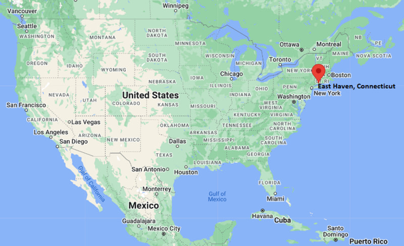
East Haven Map, Connecticut, USA
Where is East Haven?: The Google Map showing the location of East Haven in the U.S. state of Connecticut.
Where is East Haven Located?
East Haven is a city located in the Essex County of Connecticut, United States. East Haven lies between 38.5496 Degrees North latitudes and 75.1232 Degrees West longitudes. According to 2020 U.S.census, the population of East Haven city is 27923 people and the city has a total area of 12.3 sq mi. The city has numerous parks and recreational facilities.
Most Viewed US Maps
| USA Sttae Map | USA Region Map | USA Road Map |
| USA County Map | Where is USA in World Map? | US ZIP Code Map |
| USA Time Zones Map | US State and Capitals Map | USA Physical Map |
Find 4,400+ U.S. Cities by State - Explore Their Locations and Get Detailed Information
East Haven, Connecticut Quick Facts
| Property | Details |
|---|---|
| Town | East Haven |
| County | New Haven County |
| State | Connecticut |
| State Capital | Hartford |
| US Region | Northeastern United States |
| Latitude | 41.2762°N |
| Longitude | 72.8687°W |
| Elevation | 13 ft (4 m) |
| Land Area | 13.4 sq mi |
| Water Area | 3.5 sq mi |
| Total Area | 16.9 sq mi |
| Population (2020 Census) | 29,598 |
| Population Density | About 2,208 per sq mi |
| ZIP Codes | 06512, 06513 |
| Area Code | 203/475 |
| Time Zone Standard | Eastern Standard Time (EST), UTC -5 |
| Time Zone Daylight | Eastern Daylight Time (EDT), UTC -4 |
| Currency | United States Dollar (USD) |
| FIPS Code | 09-22860 |
| Congressional District | Connecticut's 3rd Congressional District |
Nearby Cities to East Haven, Connecticut
- New Haven, Connecticut - West - 4 mi
- Branford, Connecticut - East - 5 mi
- North Haven, Connecticut - North - 8 mi
- Hamden, Connecticut - Northwest - 7 mi
- Guilford, Connecticut - East - 12 mi
- Wallingford, Connecticut - North - 11 mi
- West Haven, Connecticut - West - 6 mi
- Milford, Connecticut - Southwest - 12 mi
- Madison, Connecticut - East - 18 mi
- Orange, Connecticut - West - 10 mi
East Haven, Connecticut Climate and Weather Overview
| Month | Avg High (°F) | Avg Low (°F) | Avg Rainfall (in) |
|---|---|---|---|
| January | 38 | 24 | 3.6 |
| April | 58 | 42 | 4.0 |
| July | 83 | 66 | 4.1 |
| October | 65 | 50 | 4.2 |
| Annual | 61 | 45 | 49.3 |
| Climate Attribute | Details |
|---|---|
| Climate Classification (Köppen) | Humid Subtropical / Humid Continental Transition (Cfa/Dfa) |
| Annual Rainfall | About 49.3 inches |
| Annual Sunshine Days | Approximately 200 days |
| Hurricane/Tornado Risk | Low hurricane risk; very low tornado risk |
| Snowfall | About 28 inches annually |
Driving Distances from East Haven, Connecticut
| City | State | Distance (mi) | Approx. Drive Time |
|---|---|---|---|
| New Haven | Connecticut | 4 | 10 min |
| Branford | Connecticut | 5 | 12 min |
| West Haven | Connecticut | 6 | 12 min |
| Hamden | Connecticut | 7 | 15 min |
| North Haven | Connecticut | 8 | 15 min |
| Wallingford | Connecticut | 11 | 18 min |
| Milford | Connecticut | 12 | 20 min |
| Guilford | Connecticut | 12 | 20 min |
| New York City | New York | 80 | 1 hr 30 min |
| Hartford | Connecticut | 35 | 45 min |
Transportation and Connectivity in East Haven, Connecticut
| Transportation | Details |
|---|---|
| Airport Name | Tweed New Haven Airport |
| IATA Code | HVN |
| Port | Port of New Haven (regional) |
| Major Highways | Interstate 95, U.S. Route 1, Connecticut Route 100, Route 142 |
| Train/Passenger Rail | Amtrak (New Haven Union Station nearby), Metro-North Shore Line access via New Haven |
| Local Bus/Transit Service | CTtransit New Haven Division |
- East Haven is directly connected to New Haven via main road corridors and coastal routes along Long Island Sound.
- Interstate 95 provides east-west travel along Connecticut’s shoreline corridor.
- New Haven Union Station offers Amtrak and commuter rail service to New York and Boston.
- Tweed New Haven Airport is located nearby and supports regional commercial flights.
Key Landmarks and Places to Visit in East Haven, Connecticut
| Landmark Name | Type |
|---|---|
| Lighthouse Point Park | Beach & Park |
| East Haven Town Beach | Public Beach |
| Farm River State Park | State Park |
| Silver Sands State Park (nearby) | State Park |
| Bradley Point | Coastal Landmark |
| East Haven Green | Historic Town Center |
| Shore Line Trolley Museum | Transportation Museum |
| New Haven Harbor (regional access) | Harbor |
| Fort Nathan Hale (nearby New Haven) | Historic Site |
| Yale Peabody Museum (nearby New Haven) | Museum |
Colleges and Universities in East Haven, Connecticut
| Institution | Type | Level | Notable For |
|---|---|---|---|
| Yale University | Private | University | Law, medicine, research, humanities, and sciences |
| University of New Haven | Private | University | Criminal justice, engineering, business, and cybersecurity |
| Southern Connecticut State University | Public | University | Education, health sciences, and liberal arts |
| Gateway Community College | Public | Community College | Associate degrees and workforce training |
| Albertus Magnus College | Private | College | Liberal arts, business, and education |
Waterbodies in East Haven, Connecticut
Long Island Sound, Farm River, Morris Creek, Tuttle Brook, Lake Saltonstall (nearby), New Haven Harbor, Foxon Brook, Iron Stream.
Golf Courses in East Haven, Connecticut
Alling Memorial Golf Course (nearby New Haven), Grassy Hill Country Club (regional), Race Brook Country Club (regional), Laurel View Country Club (regional), Great River Golf Club (regional), Pine Orchard Yacht & Country Club (regional).
East Haven, Connecticut - Key Historical Facts
- East Haven was settled in the 17th century as part of the early New Haven Colony.
- The town developed along coastal and river routes that supported fishing, farming, and trade.
- Shipbuilding and maritime activity played an important role in its early economy due to access to Long Island Sound.
- In the 19th and early 20th centuries, East Haven grew with New Haven’s industrial expansion.
- Post-World War II suburban growth transformed it into a residential community within the Greater New Haven area.
- Today, East Haven is known for its shoreline parks, beaches, and proximity to New Haven’s educational and cultural institutions.
References
Connecticut Maps and Info
- Where is Ansonia
- Where is Bethel
- Where is Bridgeport
- Where is Bristol
- Where is Cheshire Village
- Where is Cos Cob
- Where is Danbury
- Where is Derby
- Where is East Hartford
- Where is East Haven
- Where is Glastonbury Center
- Where is Greenwich
- Where is Groton
- Where is Hartford
- Where is Hazardville
- Where is Kensington
- Where is Manchester
- Where is Meriden
- Where is Middletown
- Where is Milford
- Where is Naugatuck
- Where is New Britain
- Where is New Haven
- Where is New London
- Where is New Milford
- Where is Newington
- Where is North Haven
- Where is Norwalk
- Where is Norwich
- Where is Oakville
- Where is Old Greenwich
- Where is Orange
- Where is Putnam
- Where is Ridgefield
- Where is Rockville
- Where is Shelton
- Where is Southwood Acres
- Where is Stamford
- Where is Storrs
- Where is Thompsonville
- Where is Torrington
- Where is Wallingford Center
- Where is Waterbury
- Where is West Hartford
- Where is West Haven
- Where is Wethersfield
- Where is Willimantic
- Where is Windsor Locks
- Where is Winsted