
Where is Dover Located? - Dover is a city located in the Strafford County of New Hampshire, United States. Dover lies between 43.19001 Degrees North latitudes and -70.8849 Degrees West longitudes.
Location Map of Dover, New Hampshire
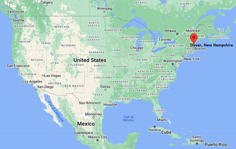
Dover Map, New Hampshire, USA
Where is Dover?: The Google Map showing the location of Dover in the U.S. state of New Hampshire.
Where is Dover Located?
Dover is a city located in the Strafford County of New Hampshire, United States. Dover lies between 43.19001 Degrees North latitudes and -70.8849 Degrees West longitudes. According to 2020 U.S.census, the population of Dover city is 32741 people and the city has a total area of 29.044 sq mi. The city has numerous parks and recreational facilities.
Most Viewed US Maps
| USA Sttae Map | USA Region Map | USA Road Map |
| USA County Map | Where is USA in World Map? | US ZIP Code Map |
| USA Time Zones Map | US State and Capitals Map | USA Physical Map |
Find 4,400+ U.S. Cities by State - Explore Their Locations and Get Detailed Information
Dover, New Hampshire Quick Facts
| Property | Details |
|---|---|
| City | Dover |
| County | Strafford County |
| State | New Hampshire |
| State Capital | Concord |
| US Region | Northeastern United States (New England) |
| Latitude | 43.19001 N |
| Longitude | -70.8849 W |
| Elevation | 56 ft (17 m) |
| Land Area | 28.74 sq mi |
| Water Area | 0.75 sq mi |
| Total Area | 29.044 sq mi |
| Population (2020 Census) | 32,741 |
| Population Density | About 1,139 per sq mi |
| ZIP Codes | 03820, 03821, 03822 |
| Area Code | 603 |
| Time Zone Standard | Eastern Standard Time (EST), UTC -5 |
| Time Zone Daylight | Eastern Daylight Time (EDT), UTC -4 |
| Currency | United States Dollar (USD) |
| FIPS Code | 33-18820 |
| Congressional District | New Hampshire's 1st Congressional District |
Nearby Cities to Dover, New Hampshire
- Somersworth, New Hampshire - Northeast - 4 mi
- Rollinsford, New Hampshire - East - 5 mi
- Rochester, New Hampshire - Northwest - 11 mi
- Durham, New Hampshire - Southwest - 11 mi
- Portsmouth, New Hampshire - Southeast - 13 mi
- South Berwick, Maine - East - 7 mi
- Berwick, Maine - Northeast - 10 mi
- Exeter, New Hampshire - South - 18 mi
- Concord, New Hampshire - West - 44 mi
- Manchester, New Hampshire - Southwest - 50 mi
Dover, New Hampshire Climate and Weather Overview
| Month | Avg High (°F) | Avg Low (°F) | Avg Rainfall (in) |
|---|---|---|---|
| January | 34 | 16 | 3.8 |
| April | 56 | 36 | 4.1 |
| July | 81 | 61 | 3.5 |
| October | 61 | 41 | 4.2 |
| Annual | 58 | 39 | 48.0 |
| Climate Attribute | Details |
|---|---|
| Climate Classification (Köppen) | Warm-Summer Humid Continental (Dfb) |
| Annual Rainfall | About 48 inches |
| Annual Sunshine Days | Approximately 200 days |
| Hurricane/Tornado Risk | Low hurricane risk; low tornado risk |
| Snowfall | About 56 inches annually |
Driving Distances from Dover, New Hampshire
| City | State | Distance (mi) | Approx. Drive Time |
|---|---|---|---|
| Somersworth | New Hampshire | 4 | 8 min |
| Rollinsford | New Hampshire | 5 | 10 min |
| South Berwick | Maine | 7 | 12 min |
| Berwick | Maine | 10 | 15 min |
| Durham | New Hampshire | 11 | 16 min |
| Rochester | New Hampshire | 11 | 18 min |
| Portsmouth | New Hampshire | 13 | 20 min |
| Exeter | New Hampshire | 18 | 25 min |
| Concord | New Hampshire | 44 | 50 min |
| Manchester | New Hampshire | 50 | 55 min |
Transportation and Connectivity in Dover, New Hampshire
| Transportation | Details |
|---|---|
| Airport Name | Portsmouth International Airport at Pease |
| IATA Code | PSM |
| Port | Port of Portsmouth (regional access) |
| Major Highways | New Hampshire Route 16 (Spaulding Turnpike), US Highway 4, New Hampshire Route 9 |
| Train/Passenger Rail | Amtrak Downeaster |
| Local Bus/Transit Service | COAST (Cooperative Alliance for Seacoast Transportation) |
- The Spaulding Turnpike (NH Route 16) provides direct connections to Portsmouth, Rochester, and northern New Hampshire.
- Amtrak's Downeaster serves Dover with daily passenger rail service between Brunswick, Maine, and Boston, Massachusetts.
- COAST operates local and regional bus routes connecting Dover with Portsmouth, Durham, Rochester, and surrounding Seacoast communities.
- Portsmouth International Airport at Pease is approximately 12 miles southeast and provides commercial, charter, and general aviation services.
Key Landmarks and Places to Visit in Dover, New Hampshire
| Landmark Name | Type |
|---|---|
| Children's Museum of New Hampshire | Children's Museum |
| Woodman Museum | History Museum |
| Henry Law Park | City Park |
| Garrison Hill Park | Scenic Park |
| Bellamy River Wildlife Management Area | Wildlife Area |
| Downtown Dover | Historic District |
| Cochecho Falls | Natural Landmark |
| The Mills at Cochecho | Historic Mill Complex |
| Hilton Park | Waterfront Park |
| UNH Observatory | Educational Attraction |
Colleges and Universities in Dover, New Hampshire
| Institution | Type | Level | Notable For |
|---|---|---|---|
| University of New Hampshire | Public | University | Research, engineering, marine science, and business programs |
| Great Bay Community College | Public | Community College | Healthcare, business, and technical education |
| University of New Hampshire School of Law | Public | Law School | Intellectual property and legal education |
| Southern New Hampshire University | Private | University | Business, online education, and graduate programs |
| York County Community College | Public | Community College | Associate degrees and workforce development |
Waterbodies in Dover, New Hampshire
Cochecho River, Bellamy River, Piscataqua River, Salmon Falls River, Willand Pond, Bellamy Reservoir, Great Bay, Little Bay.
Golf Courses in Dover, New Hampshire
Cochecho Country Club, The Oaks Golf Links, Pease Golf Course, Rochester Country Club, Breakfast Hill Golf Club, Nippo Lake Golf Club.
Dover, New Hampshire - Key Historical Facts
- Dover was settled in 1623, making it the oldest permanent settlement in New Hampshire and one of the earliest English settlements in the United States.
- The city grew around the Cochecho River, where water-powered sawmills, gristmills, and later textile mills fueled its economic development during the colonial era and the Industrial Revolution.
- Dover was officially incorporated as a city in 1855 after decades of growth driven by manufacturing, trade, and shipbuilding.
- Throughout the 19th century, the Cocheco Manufacturing Company became one of the region's leading textile producers, helping transform Dover into an important industrial center.
- Many of Dover's historic brick mill buildings and downtown streets have been preserved and are now home to businesses, restaurants, museums, and cultural venues.
- Today, Dover is recognized for its historic character, thriving downtown, higher education opportunities, proximity to New Hampshire's Seacoast, and strong healthcare, technology, and service industries.
References
More New Hampshire Maps & Info
- Where is Berlin
- Where is Bristol
- Where is Claremont
- Where is Concord
- Where is Conway
- Where is Derry
- Where is Dover
- Where is East Merrimack
- Where is Enfield
- Where is Epping
- Where is Exeter
- Where is Farmington
- Where is Franklin
- Where is Goffstown
- Where is Gorham
- Where is Hampton
- Where is Hampton Beach
- Where is Hanover
- Where is Henniker
- Where is Hillsborough
- Where is Hooksett
- Where is Hudson
- Where is Jaffrey
- Where is Keene
- Where is Laconia
- Where is Lancaster
- Where is Lebanon
- Where is Littleton
- Where is Londonderry
- Where is Manchester
- Where is Meredith
- Where is Milford
- Where is Nashua
- Where is Newmarket
- Where is Newport
- Where is North Conway
- Where is Peterborough
- Where is Pinardville
- Where is Pittsfield
- Where is Plymouth
- Where is Portsmouth
- Where is Raymond
- Where is Somersworth
- Where is South Hooksett
- Where is Suncook
- Where is Tilton Northfield
- Where is Winchester
- Where is Wolfeboro