
Where is Epping Located? - Epping is a city located in the Rockingham County of New Hampshire, United States. Epping lies between 47.3073228 Degrees North latitudes and 122.2284532 Degrees West longitudes.
Location Map of Epping, New Hampshire
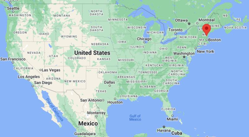
Epping Map, New Hampshire, USA
Where is Epping?: The Google Map showing the location of Epping in the U.S. state of New Hampshire.
Where is Epping Located?
Epping is a city located in the Rockingham County of New Hampshire, United States. Epping lies between 47.3073228 Degrees North latitudes and 122.2284532 Degrees West longitudes. According to 2020 U.S.census, the population of Epping city is 2693 people and the city has a total area of 2.74 sq mi. The city has numerous parks and recreational facilities.
Most Viewed US Maps
| USA Sttae Map | USA Region Map | USA Road Map |
| USA County Map | Where is USA in World Map? | US ZIP Code Map |
| USA Time Zones Map | US State and Capitals Map | USA Physical Map |
Find 4,400+ U.S. Cities by State - Explore Their Locations and Get Detailed Information
Epping, New Hampshire Quick Facts
| Property | Details |
|---|---|
| Town | Epping |
| County | Rockingham County |
| State | New Hampshire |
| State Capital | Concord |
| US Region | Northeast |
| Latitude | 43.0337°N |
| Longitude | 71.0745°W |
| Elevation | 131 ft (40 m) |
| Land Area | 26.19 sq mi |
| Water Area | 0.39 sq mi |
| Total Area | 26.58 sq mi |
| Population (2020 Census) | 7,412 |
| Population Density | Approximately 283 per sq mi |
| ZIP Code | 03042 |
| Area Code | 603 |
| Time Zone Standard | Eastern Standard Time (EST), UTC−5 |
| Time Zone Daylight | Eastern Daylight Time (EDT), UTC−4 |
| Currency | US Dollar (USD) |
| FIPS Code | 33-24420 |
| Congressional District | New Hampshire's 1st Congressional District |
Nearby Cities to Epping, New Hampshire
- Exeter, New Hampshire - East - 9 mi
- Newmarket, New Hampshire - Northeast - 10 mi
- Raymond, New Hampshire - West - 7 mi
- Brentwood, New Hampshire - Southeast - 5 mi
- Fremont, New Hampshire - South - 6 mi
- Candia, New Hampshire - West - 12 mi
- Portsmouth, New Hampshire - East - 22 mi
- Manchester, New Hampshire - Southwest - 24 mi
- Dover, New Hampshire - Northeast - 24 mi
- Concord, New Hampshire - Northwest - 33 mi
Epping, New Hampshire Climate and Weather Overview
| Month | Avg High (°F) | Avg Low (°F) | Avg Rainfall (in) |
|---|---|---|---|
| January | 35 | 16 | 3.70 |
| April | 58 | 37 | 4.20 |
| July | 82 | 62 | 3.60 |
| October | 63 | 43 | 4.10 |
| Annual | 60 | 40 | 49.00 |
| Climate Attribute | Details |
|---|---|
| Climate Classification (Köppen) | Humid Continental (Dfb) |
| Annual Rainfall | Approximately 49 inches |
| Annual Sunshine Days | About 200 days |
| Hurricane/Tornado Risk | Low hurricane risk; very low tornado risk |
| Snowfall | Approximately 56 inches annually |
Driving Distances from Epping, New Hampshire
| City | State | Distance (mi) | Approx. Drive Time |
|---|---|---|---|
| Brentwood | New Hampshire | 5 | 8 min |
| Fremont | New Hampshire | 6 | 10 min |
| Raymond | New Hampshire | 7 | 10 min |
| Exeter | New Hampshire | 9 | 15 min |
| Newmarket | New Hampshire | 10 | 18 min |
| Candia | New Hampshire | 12 | 18 min |
| Portsmouth | New Hampshire | 22 | 30 min |
| Manchester | New Hampshire | 24 | 30 min |
| Dover | New Hampshire | 24 | 35 min |
| Concord | New Hampshire | 33 | 40 min |
Transportation and Connectivity in Epping, New Hampshire
| Transportation | Details |
|---|---|
| Airport Name | Portsmouth International Airport at Pease |
| IATA Code | PSM |
| Port | Port of Portsmouth (regional) |
| Major Highways | New Hampshire Route 101, New Hampshire Route 125, New Hampshire Route 27 |
| Train/Amtrak Service | No passenger rail service; nearest Amtrak station is Exeter (Amtrak Downeaster) |
| Local Bus/Transit Service | COAST regional transit (limited service nearby) |
- New Hampshire Route 101 is the primary east-west corridor connecting Epping with Manchester, Exeter, and the Seacoast region.
- Routes 125 and 27 provide convenient access to neighboring Rockingham County communities.
- The nearest Amtrak Downeaster station is located in Exeter, offering rail service to Boston and Portland.
- Portsmouth International Airport at Pease, approximately 20 miles away, serves commercial, charter, and general aviation traffic.
Places to Visit in Epping, New Hampshire
| Landmark Name | Type |
|---|---|
| New England Dragway | Motorsports Venue |
| Pawtuckaway State Park | State Park |
| Brickyard Square | Shopping Center |
| Governor's Rail Trail | Multi-Use Trail |
| Rockingham Recreational Rail Trail | Rail Trail |
| Exeter Historical Society Museum | History Museum |
| America's Stonehenge | Archaeological Site |
| Great Bay National Wildlife Refuge | Wildlife Refuge |
| Fort Constitution Historic Site | Historic Site |
| Strawbery Banke Museum | Living History Museum |
Colleges and Universities in Epping, New Hampshire
| Institution Name | Type | Level | Notable For |
|---|---|---|---|
| Great Bay Community College | Public | Community College | Associate degrees and workforce training |
| University of New Hampshire | Public | University | Research, engineering, and agriculture |
| Southern New Hampshire University | Private | University | Business and online education |
| University of New Hampshire at Manchester | Public | University | Business and liberal arts |
| Manchester Community College | Public | Community College | Career and technical education |
| Rivier University | Private | University | Nursing and education |
| Saint Anselm College | Private | College | Liberal arts education |
| Epping School District | Public | K–12 District | Primary and secondary education |
Waterbodies in Epping, New Hampshire
Lamprey River, Piscassic River, Great Bay, Pawtuckaway Lake, Mendums Pond, North River, Exeter River, Squamscott River
Golf Courses in Epping, New Hampshire
Apple Hill Golf Course, Candia Woods Golf Links, Breakfast Hill Golf Club, The Oaks Golf Links, Portsmouth Country Club, Exeter Country Club, Beaver Meadow Golf Course, Pease Golf Course
Epping, New Hampshire — Key Historical Facts
- Epping was incorporated in 1741 after separating from Exeter and was named after Epping in Essex, England.
- The Lamprey River powered numerous sawmills, gristmills, and textile mills that supported the town's economy throughout the 18th and 19th centuries.
- During the railroad era, Epping became an important transportation and agricultural trading center for southeastern New Hampshire.
- The town has preserved several historic buildings and landmarks that reflect its colonial heritage and industrial development.
- Modern commercial growth along New Hampshire Route 101 has transformed Epping into a regional shopping and service center while maintaining its small-town character.
- Today, Epping is known for outdoor recreation, motorsports at New England Dragway, historic sites, and its convenient location between Manchester and the New Hampshire Seacoast.
References
- Town of Epping
- U.S. Census Bureau
- New Hampshire Division of Travel and Tourism Development
- New Hampshire Historical Society
More New Hampshire Maps & Info
- Where is Berlin
- Where is Bristol
- Where is Claremont
- Where is Concord
- Where is Conway
- Where is Derry
- Where is Dover
- Where is East Merrimack
- Where is Enfield
- Where is Epping
- Where is Exeter
- Where is Farmington
- Where is Franklin
- Where is Goffstown
- Where is Gorham
- Where is Hampton
- Where is Hampton Beach
- Where is Hanover
- Where is Henniker
- Where is Hillsborough
- Where is Hooksett
- Where is Hudson
- Where is Jaffrey
- Where is Keene
- Where is Laconia
- Where is Lancaster
- Where is Lebanon
- Where is Littleton
- Where is Londonderry
- Where is Manchester
- Where is Meredith
- Where is Milford
- Where is Nashua
- Where is Newmarket
- Where is Newport
- Where is North Conway
- Where is Peterborough
- Where is Pinardville
- Where is Pittsfield
- Where is Plymouth
- Where is Portsmouth
- Where is Raymond
- Where is Somersworth
- Where is South Hooksett
- Where is Suncook
- Where is Tilton Northfield
- Where is Winchester
- Where is Wolfeboro