
Where is Farmington Located? - Farmington is a city located in the Strafford County of New Hampshire, United States. Farmington lies between 47.9789848 Degrees North latitudes and 122.2020794 Degrees West longitudes.
Location Map of Farmington, New Hampshire
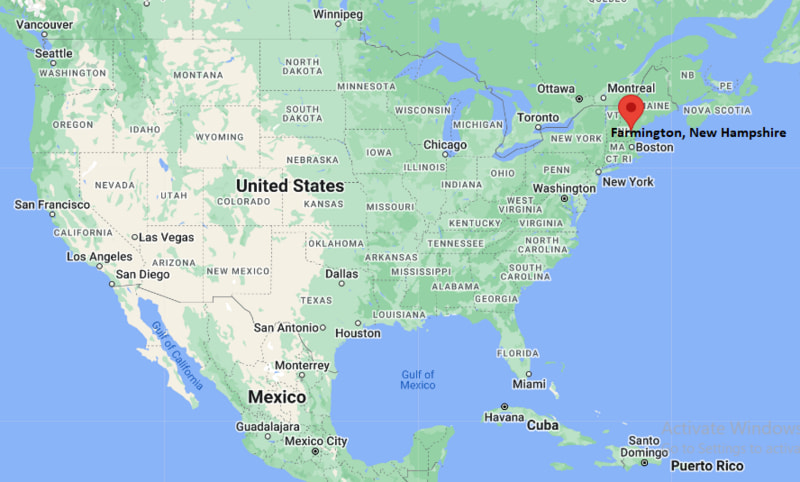
Farmington Map, New Hampshire, USA
Where is Farmington?: The Google Map showing the location of Farmington in the U.S. state of New Hampshire.
Where is Farmington Located?
Farmington is a city located in the Strafford County of New Hampshire, United States. Farmington lies between 47.9789848 Degrees North latitudes and 122.2020794 Degrees West longitudes. According to 2020 U.S.census, the population of Farmington city is 3824 people and the city has a total area of 6.22 sq mi. The city has numerous parks and recreational facilities.
Most Viewed US Maps
| USA Sttae Map | USA Region Map | USA Road Map |
| USA County Map | Where is USA in World Map? | US ZIP Code Map |
| USA Time Zones Map | US State and Capitals Map | USA Physical Map |
Find 4,400+ U.S. Cities by State - Explore Their Locations and Get Detailed Information
Farmington, Maine Quick Facts
| Property | Information |
|---|---|
| City | Farmington |
| County | Strafford County |
| State | New Hampshire |
| State Capital | Concord |
| US Region | Northeastern United States |
| Latitude | 43.3868° N |
| Longitude | 71.0664° W |
| Elevation | 423 ft (129 m) |
| Land Area | 37.79 sq mi |
| Water Area | 0.69 sq mi |
| Total Area | 38.48 sq mi |
| Population (latest Census year) | 7,555 (2020 Census) |
| Population Density | 200 per sq mi |
| ZIP Codes | 03835 |
| Area Code | 603 |
| Time Zone Standard | Eastern Standard Time (EST, UTC−5) |
| Time Zone Daylight | Eastern Daylight Time (EDT, UTC−4) |
| Currency | US Dollar (USD) |
| FIPS Code | 33-25860 |
| Congressional District | 1st Congressional District |
Nearby Cities to Farmington, New Hampshire
- Rochester, New Hampshire — 8 mi Southeast
- Milton, New Hampshire — 6 mi East
- Somersworth, New Hampshire — 14 mi Southeast
- Dover, New Hampshire — 16 mi Southeast
- Alton, New Hampshire — 16 mi Northwest
- Wolfeboro, New Hampshire — 18 mi North
- Barrington, New Hampshire — 9 mi South
- Durham, New Hampshire — 23 mi South
- Laconia, New Hampshire — 28 mi Northwest
- Portsmouth, New Hampshire — 28 mi Southeast
Driving Distances from Farmington, New Hampshire
| City | State | Distance (mi) | Approx. Drive Time |
|---|---|---|---|
| Rochester | New Hampshire | 8 | 12 min |
| Milton | New Hampshire | 6 | 10 min |
| Barrington | New Hampshire | 9 | 15 min |
| Dover | New Hampshire | 16 | 22 min |
| Alton | New Hampshire | 16 | 25 min |
| Wolfeboro | New Hampshire | 18 | 28 min |
| Portsmouth | New Hampshire | 28 | 35 min |
| Laconia | New Hampshire | 28 | 40 min |
| Concord | New Hampshire | 39 | 50 min |
| Manchester | New Hampshire | 51 | 1 hr |
Transportation and Connectivity in Farmington, New Hampshire
| Category | Information |
|---|---|
| Airport Name | Portsmouth International Airport at Pease (nearest commercial airport) |
| IATA Code | PSM |
| Port | Not applicable |
| Major Highways | New Hampshire Route 11, New Hampshire Route 75, New Hampshire Route 153, U.S. Route 202 (nearby) |
| Train/Amtrak Service | No passenger rail service; nearest Amtrak station is Dover |
| Local Bus/Transit Service | COAST regional transit (nearby Rochester and Dover) |
- New Hampshire Route 11 - Primary east-west highway connecting Farmington with Rochester, Alton and the Lakes Region.
- New Hampshire Route 153 - Scenic north-south route linking the town with Wakefield, Sanbornville and Effingham.
- New Hampshire Route 75 - Local connector serving Farmington's downtown and surrounding neighborhoods.
- U.S. Route 202 - Nearby regional highway providing access to Rochester, Concord and southern Maine.
What are top Places to Visit in Farmington, New Hampshire
| Landmark Name | Type |
|---|---|
| Blue Job Mountain | Hiking Area |
| Blue Job State Forest | State Forest |
| Baxter Lake | Lake |
| Farmington Country Club | Golf Course |
| Downtown Farmington Historic District | Historic District |
| Rochester Opera House | Historic Theater |
| McDaniel Marsh Wildlife Management Area | Wildlife Area |
| Bow Lake | Recreation Area |
| Milton Three Ponds | Natural Attraction |
| New Hampshire Farm Museum | Museum |
Colleges and Universities in Farmington, New Hampshire
| Institution Name | Type | Level | Notable For |
|---|---|---|---|
| University of New Hampshire | Public | University | Flagship research university |
| Great Bay Community College | Public | Community College | Career and transfer programs |
| NHTI – Concord's Community College | Public | Community College | Technical and health sciences education |
| Farmington School District (SAU 61) | Public | K–12 District | Public elementary and secondary education |
Waterbodies in Farmington, New Hampshire
Cocheco River, Baxter Lake, Marchs Pond, Bow Lake, Merrymeeting River, Milton Three Ponds, Nippo Lake, Salmon Falls River
Golf Courses in Farmington, New Hampshire
Farmington Country Club, Nippo Lake Golf Club, Rochester Country Club, Cochecho Country Club, Province Lake Golf Course, Kingswood Golf Club
Farmington, New Hampshire — Key Historical Facts
- Farmington was incorporated in 1798 after separating from Rochester and developed as an agricultural and mill community.
- The Cocheco River provided water power that supported textile mills, sawmills, and other local industries during the nineteenth century.
- The arrival of the railroad helped expand trade and transportation, strengthening Farmington's role within Strafford County.
- Historic buildings in the town center reflect Farmington's growth during New Hampshire's industrial era and remain an important part of the community's character.
- Today, Farmington offers small-town living with easy access to the New Hampshire Seacoast, the Lakes Region, and outdoor recreation throughout southeastern New Hampshire.
References
More New Hampshire Maps & Info
- Where is Berlin
- Where is Bristol
- Where is Claremont
- Where is Concord
- Where is Conway
- Where is Derry
- Where is Dover
- Where is East Merrimack
- Where is Enfield
- Where is Epping
- Where is Exeter
- Where is Farmington
- Where is Franklin
- Where is Goffstown
- Where is Gorham
- Where is Hampton
- Where is Hampton Beach
- Where is Hanover
- Where is Henniker
- Where is Hillsborough
- Where is Hooksett
- Where is Hudson
- Where is Jaffrey
- Where is Keene
- Where is Laconia
- Where is Lancaster
- Where is Lebanon
- Where is Littleton
- Where is Londonderry
- Where is Manchester
- Where is Meredith
- Where is Milford
- Where is Nashua
- Where is Newmarket
- Where is Newport
- Where is North Conway
- Where is Peterborough
- Where is Pinardville
- Where is Pittsfield
- Where is Plymouth
- Where is Portsmouth
- Where is Raymond
- Where is Somersworth
- Where is South Hooksett
- Where is Suncook
- Where is Tilton Northfield
- Where is Winchester
- Where is Wolfeboro