
Where is Haverhill Located? - Haverhill is a city located in the Essex County of Massachusetts, United States. Haverhill lies between 30.3088076 Degrees North latitudes and 89.3300461 Degrees West longitudes.
Location Map of Haverhill, Massachusetts
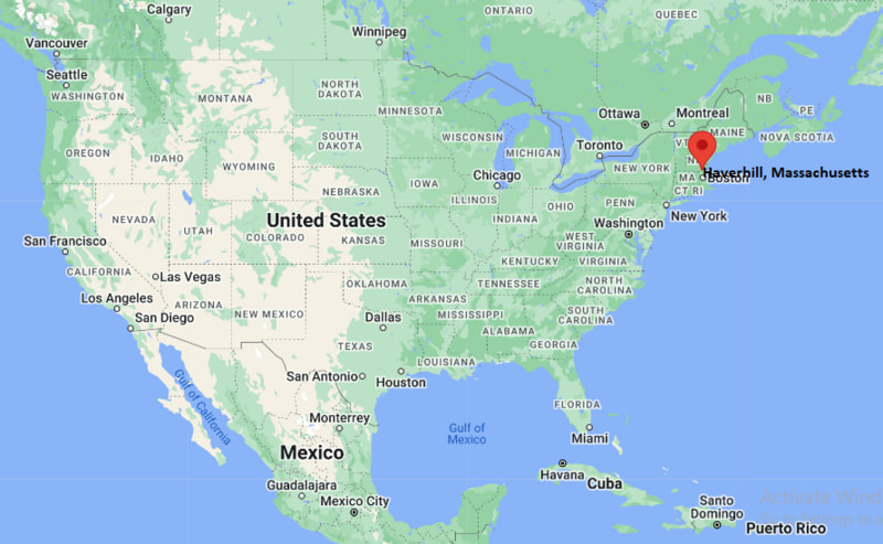
Haverhill Map, Massachusetts, USA
Where is Haverhill?: The Google Map showing the location of Haverhill in the U.S. state of Massachusetts.
Where is Haverhill Located?
Haverhill is a city located in the Essex County of Massachusetts, United States. Haverhill lies between 30.3088076 Degrees North latitudes and 89.3300461 Degrees West longitudes. According to 2020 U.S.census, the population of Haverhill city is 67787 people and the city has a total area of 33.04 sq mi. The city has numerous parks and recreational facilities.
Most Viewed US Maps
| USA Sttae Map | USA Region Map | USA Road Map |
| USA County Map | Where is USA in World Map? | US ZIP Code Map |
| USA Time Zones Map | US State and Capitals Map | USA Physical Map |
Find 4,400+ U.S. Cities by State - Explore Their Locations and Get Detailed Information
Haverhill, Massachusetts Quick Facts
| Property | Information |
|---|---|
| City | Haverhill |
| County | Essex County |
| State | Massachusetts |
| State Capital | Boston |
| US Region | Northeastern United States |
| Latitude | 42.7762°N |
| Longitude | 71.0773°W |
| Elevation | 66 ft (20 m) |
| Land Area | 33.09 sq mi |
| Water Area | 2.03 sq mi |
| Total Area | 35.12 sq mi |
| Population (latest Census year) | 67,787 (Census 2020) |
| Population Density | Approximately 2,049 per sq mi |
| ZIP Codes | 01830, 01831, 01832, 01835 |
| Area Code | 351, 978 |
| Time Zone Standard | Eastern Standard Time (EST, UTC−5) |
| Time Zone Daylight | Eastern Daylight Time (EDT, UTC−4) |
| Currency | US Dollar (USD) |
| FIPS Code | 25-29405 |
| Congressional District | Massachusetts's 6th Congressional District |
Nearby Cities to Haverhill, Massachusetts
- Groveland, Massachusetts - Southeast - 4 mi
- Bradford, Massachusetts - West - 2 mi
- Amesbury, Massachusetts - East - 10 mi
- Lawrence, Massachusetts - Southwest - 11 mi
- Methuen, Massachusetts - Southwest - 9 mi
- Newburyport, Massachusetts - East - 15 mi
- Salem, New Hampshire - West - 16 mi
- Andover, Massachusetts - Southwest - 15 mi
- Lowell, Massachusetts - West - 26 mi
- Boston, Massachusetts - South - 37 mi
Driving Distances from Haverhill, Massachusetts
| City | State | Distance (mi) | Approx. Drive Time |
|---|---|---|---|
| Bradford | Massachusetts | 2 | 5 minutes |
| Groveland | Massachusetts | 4 | 10 minutes |
| Methuen | Massachusetts | 9 | 15 minutes |
| Amesbury | Massachusetts | 10 | 15 minutes |
| Lawrence | Massachusetts | 11 | 20 minutes |
| Newburyport | Massachusetts | 15 | 25 minutes |
| Andover | Massachusetts | 15 | 25 minutes |
| Salem | New Hampshire | 16 | 25 minutes |
| Lowell | Massachusetts | 26 | 35 minutes |
| Boston | Massachusetts | 37 | 50 minutes |
Transportation and Connectivity in Haverhill, Massachusetts
| Transportation | Details |
|---|---|
| Airport Name | Manchester-Boston Regional Airport (nearest major airport) |
| IATA Code | MHT |
| Port | Port of Boston |
| Major Highways | Interstate 495, Massachusetts Route 97, Massachusetts Route 110, U.S. Route 202 |
| Train/Amtrak Service | MBTA Haverhill Line; Amtrak Downeaster at nearby Exeter and Woburn stations |
| Local Bus/Transit Service | Merrimack Valley Transit (MeVa) |
- Interstate 495 provides convenient highway access to Boston, New Hampshire, and the greater New England region.
- The MBTA Haverhill Line offers commuter rail service between Haverhill and Boston's North Station.
- Merrimack Valley Transit (MeVa) operates local and regional bus routes serving Haverhill and neighboring communities.
- Manchester-Boston Regional Airport is approximately 30 miles northwest, while Boston Logan International Airport is about 40 miles south.
- Haverhill's location along the Merrimack River and near the New Hampshire border makes it an important commercial and transportation hub in northeastern Massachusetts.
What are top Places to Visit in Haverhill, Massachusetts
| Landmark Name | Type |
|---|---|
| Winnekenni Castle | Historic Landmark |
| Winnekenni Park | City Park |
| Buttonwoods Museum | History Museum |
| Plug Pond Recreation Area | Lake & Park |
| Merrimack River Waterfront | Scenic Riverfront |
| Tattersall Farm | Nature Preserve |
| Cedar Dale Conservation Area | Nature Preserve |
| John Greenleaf Whittier Birthplace | Historic House Museum |
| Bradford Rail Trail | Walking & Cycling Trail |
| Crystal Gorge Conservation Area | Outdoor Recreation Area |
Colleges and Universities in Haverhill, Massachusetts
| Institution | Type | Level | Notable For |
|---|---|---|---|
| Northern Essex Community College – Haverhill Campus | Public | Community College | Associate degrees, workforce training, and university transfer programs |
| Merrimack College | Private | College | Business, engineering, education, and liberal arts |
| University of Massachusetts Lowell | Public | University | Engineering, business, health sciences, and research |
| Southern New Hampshire University | Private | University | Business, technology, healthcare, and online education |
| Salem State University | Public | University | Liberal arts, education, business, and nursing |
Waterbodies in Haverhill, Massachusetts
Merrimack River, Plug Pond (Lake Saltonstall), Kenoza Lake, Millvale Reservoir, Crystal Lake, Little River, East Meadow River, Johnson Creek, Bailey Brook, Chadwick Pond
Golf Courses in Haverhill, Massachusetts
Haverhill Country Club, Crystal Lake Golf Club, Far Corner Golf Course, Atkinson Resort & Country Club, Bradford Country Club, Bradford Golf Club, Renaissance Golf Club, Merrimack Valley Golf Club
Haverhill, Massachusetts — Key Historical Facts
- Haverhill was settled in 1640 and officially incorporated in 1645, making it one of the oldest communities in Massachusetts.
- The city developed as an agricultural settlement before becoming a major center for shoe manufacturing during the nineteenth century.
- By the late 1800s, Haverhill was known as the "Queen Slipper City" because it was one of the world's leading producers of footwear.
- The Merrimack River and expanding railroad network played vital roles in the city's industrial growth and commercial success.
- Today, Haverhill is recognized for its revitalized downtown, historic architecture, riverfront attractions, educational institutions, and diverse economy within the Greater Boston metropolitan area.
References
- City of Haverhill
- Massachusetts Secretary of the Commonwealth
- U.S. Census Bureau
- Northern Essex Community College
Massachusetts Related Maps and Info
- Where is Attleboro
- Where is Barnstable Town
- Where is Beverly
- Where is Braintree Town
- Where is Brockton
- Where is Brookline
- Where is Cambridge
- Where is Chelsea
- Where is Chicopee
- Where is Everett
- Where is Fall River
- Where is Fitchburg
- Where is Franklin Town
- Where is Gloucester
- Where is Haverhill
- Where is Holyoke
- Where is Lawrence
- Where is Leominster
- Where is Lowell
- Where is Lynn
- Where is Malden
- Where is Marlborough
- Where is Medford
- Where is Melrose
- Where is Methuen Town
- Where is Milton
- Where is Needham
- Where is New Bedford
- Where is Newton
- Where is Northampton
- Where is Norwood
- Where is Peabody
- Where is Pittsfield
- Where is Quincy
- Where is Revere
- Where is Saugus
- Where is Somerville
- Where is Taunton
- Where is Waltham
- Where is Watertown Town
- Where is Wellesley
- Where is Westfield
- Where is Weymouth Town
- Where is Woburn
- Where is Worcester