
Where is Beverly Located? - Beverly is a city located in the Essex County of Massachusetts, United States. Beverly lies between 42.56083 Degrees North latitudes and -70.8759 Degrees West longitudes.
Location Map of Beverly, Massachusetts
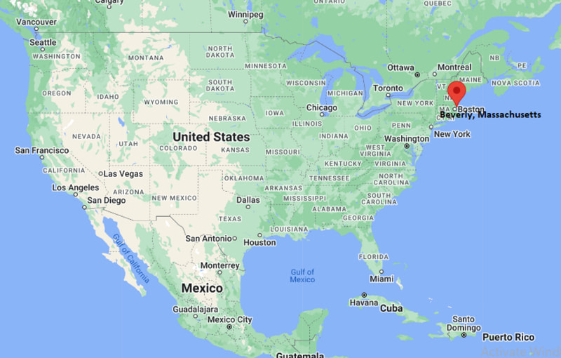
Beverly Map, Massachusetts, USA
Where is Beverly?: The Google Map showing the location of Beverly in the U.S. state of Massachusetts.
Where is Beverly Located?
Beverly is a city located in the Essex County of Massachusetts, United States. Beverly lies between 42.56083 Degrees North latitude and -70.8759 Degrees West longitude. According to the 2020 U.S. Census, the population of Beverly city is 42,670 people and the city has a total area of 22.587 sq mi. The city has numerous parks and recreational facilities.
Most Viewed US Maps
| USA Sttae Map | USA Region Map | USA Road Map |
| USA County Map | Where is USA in World Map? | US ZIP Code Map |
| USA Time Zones Map | US State and Capitals Map | USA Physical Map |
Find 4,400+ U.S. Cities by State - Explore Their Locations and Get Detailed Information
Beverly, Massachusetts Quick Facts
| Fact | Details |
|---|---|
| City | Beverly |
| County | Essex County |
| State | Massachusetts |
| State Capital | Boston |
| Country | United States |
| US Region | Northeast |
| Latitude | 42.56083 N |
| Longitude | -70.8759 W |
| Elevation | 107 ft (33 m) |
| Land Area | 15.12 sq mi |
| Water Area | 7.05 sq mi |
| Total Area | 22.587 sq mi |
| Population (Census 2020) | 42,670 |
| Population Density | Approximately 2,823 per sq mi |
| ZIP Codes | 01915, 01965 |
| Area Codes | 351, 978 |
| Time Zone Standard | Eastern Standard Time (EST, UTC-5) |
| Time Zone Daylight | Eastern Daylight Time (EDT, UTC-4) |
| Currency | United States Dollar (USD) |
| FIPS Code | 25-05895 |
| Congressional District | Massachusetts's 6th Congressional District |
Nearby Cities and Towns to Beverly, Massachusetts
- Salem, Massachusetts - 3 mi South
- Danvers, Massachusetts - 4 mi West
- Manchester-by-the-Sea, Massachusetts - 6 mi East
- Wenham, Massachusetts - 5 mi North
- Hamilton, Massachusetts - 6 mi North
- Peabody, Massachusetts - 7 mi Southwest
- Marblehead, Massachusetts - 7 mi South
- Gloucester, Massachusetts - 12 mi Northeast
- Lynn, Massachusetts - 10 mi South
- Boston, Massachusetts - 22 mi Southwest
Beverly, Massachusetts Climate and Weather Overview
| Month | Avg High (°F) | Avg Low (°F) | Avg Rainfall (in) |
|---|---|---|---|
| January | 37 | 22 | 4.1 |
| April | 56 | 38 | 4.2 |
| July | 81 | 64 | 3.3 |
| October | 62 | 45 | 4.4 |
| Annual | 59 | 43 | 48.0 |
| Climate Attribute | Details |
|---|---|
| Climate Classification | Hot-Summer Humid Continental (Köppen Dfa) |
| Annual Rainfall | Approximately 48 inches |
| Annual Sunshine Days | About 200 days |
| Hurricane/Tornado Risk | Low - Occasional coastal storms, nor'easters and winter snowstorms |
| Snowfall | Approximately 49 inches annually |
Driving Distances from Beverly, Massachusetts
| City | State | Distance (mi) | Approx. Drive Time |
|---|---|---|---|
| Salem | Massachusetts | 3 | 8 min |
| Danvers | Massachusetts | 4 | 10 min |
| Wenham | Massachusetts | 5 | 10 min |
| Hamilton | Massachusetts | 6 | 12 min |
| Manchester-by-the-Sea | Massachusetts | 6 | 12 min |
| Peabody | Massachusetts | 7 | 15 min |
| Marblehead | Massachusetts | 7 | 18 min |
| Lynn | Massachusetts | 10 | 20 min |
| Gloucester | Massachusetts | 12 | 22 min |
| Boston | Massachusetts | 22 | 35 min |
Transportation and Connectivity in Beverly, Massachusetts
| Transportation | Details |
|---|---|
| Airport Name | Boston Logan International Airport |
| IATA Code | BOS |
| Port | Beverly Harbor |
| Major Highways | Massachusetts Route 1A, Route 22, Route 62, Route 128 |
| Train Service | MBTA Commuter Rail (Newburyport/Rockport Line) |
| Local Bus/Transit Service | Cape Ann Transportation Authority (CATA) and MBTA bus service |
- Massachusetts Route 128 provides convenient access to Boston, Interstate 95 and other North Shore communities.
- MBTA Commuter Rail serves Beverly through multiple stations on the Newburyport/Rockport Line, offering direct service to Boston's North Station.
- Beverly Harbor supports recreational boating, fishing and seasonal marine activities along the North Shore.
- Boston Logan International Airport is approximately 24 miles southwest of Beverly and offers extensive domestic and international air service.
Key Landmarks and Places to Visit in Beverly, Massachusetts
| Landmark | Type |
|---|---|
| Long Hill | Historic Estate and Gardens |
| Lynch Park | Waterfront Park |
| Cabot Theatre | Historic Performing Arts Theater |
| Independence Park | Beach and Park |
| Balch House | Historic House Museum |
| Beverly Common | Historic Public Park |
| Dane Street Beach | Public Beach |
| Salem Willows Park | Amusement and Waterfront Park |
| Endicott Park | Nature Park |
| Misery Islands Reservation | Coastal Nature Reserve |
Colleges and Universities in Beverly, Massachusetts
| Institution | Type | Level | Notable For |
|---|---|---|---|
| Endicott College | Private | College | Business, hospitality and experiential learning |
| Montserrat College of Art | Private | College | Visual arts and design |
| Salem State University | Public | University | Education, business and liberal arts |
| Gordon College | Private | College | Christian liberal arts education |
| North Shore Community College | Public | Community College | Career training and transfer programs |
| University of Massachusetts Lowell | Public | Research University | Engineering, sciences and business |
Waterbodies in Beverly, Massachusetts
Beverly Harbor, Danvers River, Bass River, Salem Sound, Atlantic Ocean, Wenham Lake, Crane River, Porter River, Ipswich Bay, Essex River.
Golf Courses in Beverly, Massachusetts
Beverly Golf & Tennis Club, Wenham Country Club, Kernwood Country Club, Salem Country Club, Ipswich Country Club, Ferncroft Country Club, Far Corner Golf Course, Sagamore Spring Golf Club.
Beverly, Massachusetts - Key Historical Facts
- Beverly was settled in the early seventeenth century and was incorporated in 1668 after separating from Salem.
- The city is often recognized as the birthplace of the United States Navy because the schooner Hannah, commissioned by George Washington in 1775, sailed from Beverly Harbor.
- Fishing, shipbuilding and maritime trade played major roles in Beverly's early economy before manufacturing became prominent during the nineteenth century.
- During the late nineteenth and early twentieth centuries, Beverly developed as a popular seaside destination with elegant summer estates and growing residential neighborhoods.
- The city later became an important center for education, healthcare and technology while preserving many of its historic buildings and coastal landscapes.
- Today, Beverly is known for its scenic waterfront, historic downtown, cultural attractions, beaches and vibrant North Shore community.
References
Massachusetts Related Maps and Info
- Where is Attleboro
- Where is Barnstable Town
- Where is Beverly
- Where is Braintree Town
- Where is Brockton
- Where is Brookline
- Where is Cambridge
- Where is Chelsea
- Where is Chicopee
- Where is Everett
- Where is Fall River
- Where is Fitchburg
- Where is Franklin Town
- Where is Gloucester
- Where is Haverhill
- Where is Holyoke
- Where is Lawrence
- Where is Leominster
- Where is Lowell
- Where is Lynn
- Where is Malden
- Where is Marlborough
- Where is Medford
- Where is Melrose
- Where is Methuen Town
- Where is Milton
- Where is Needham
- Where is New Bedford
- Where is Newton
- Where is Northampton
- Where is Norwood
- Where is Peabody
- Where is Pittsfield
- Where is Quincy
- Where is Revere
- Where is Saugus
- Where is Somerville
- Where is Taunton
- Where is Waltham
- Where is Watertown Town
- Where is Wellesley
- Where is Westfield
- Where is Weymouth Town
- Where is Woburn
- Where is Worcester