Map of Swift County - Swift County is a county located in the U.S. state of Minnesota. Swift County Map showing cities, highways, important places and water bodies. Get Where is Swift County located in the map, major cities in Swift county, population, areas, and places of interest.
Map of Swift County, Minnesota
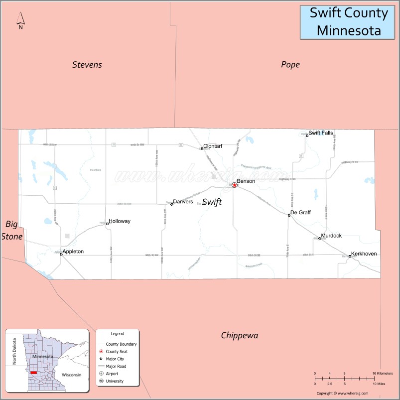
About Swift County Map, Minnesota: The map showing the county boundary, county seat, major cities, highways, water bodies and neighbouring counties.
Other Minnesota Maps & Info
Map of Swift County, Minnesota
Swift County is a county located in the U.S. state of Minnesota. It's county seat is Benson. As per 2020 census, the population of Swift County is 9749 people and population density is square miles. According to the United States Census Bureau, the county has a total area of 743.53 sq mi (1,926 km2). Swift County was established on 1870.
Swift County Facts
| County Info | Facts |
|---|---|
| County | Swift County |
| County Seat | Benson |
| State | Minnesota |
| Country | United States |
| FIPS code | 151 |
| Established | 1870 |
| Area | 743.53 sq mi (1,926 km2) |
| Population | 9749 |
| Density | |
| Formed / Origin | Chippewa County |
Ctities in Swift county
| City Name | Type | Population (2020) |
|---|---|---|
| Benson | 3,043 | |
| Appleton | 1,392 | |
| Kerkhoven | 805 | |
| Murdock | 306 | |
| Clontarf | 128 | |
| De Graff | 110 | |
| Danvers | 103 | |
| Holloway | 87 |
- Aitkin County Map
- Anoka County Map
- Becker County Map
- Beltrami County Map
- Benton County Map
- Big Stone County Map
- Blue Earth County Map
- Brown County Map
- Carlton County Map
- Carver County Map
- Cass County Map
- Chippewa County Map
- Chisago County Map
- Clay County Map
- Clearwater County Map
- Cook County Map
- Cottonwood County Map
- Crow Wing County Map
- Dakota County Map
- Dodge County Map
- Douglas County Map
- Faribault County Map
- Fillmore County Map
- Freeborn County Map
- Goodhue County Map
- Grant County Map
- Hennepin County Map
- Houston County Map
- Hubbard County Map
- Isanti County Map
- Itasca County Map
- Jackson County Map
- Kanabec County Map
- Kandiyohi County Map
- Kittson County Map
- Koochiching County Map
- Lac qui Parle County Map
- Lake County Map
- Lake of the Woods County Map
- Le Sueur County Map
- Lincoln County Map
- Lyon County Map
- McLeod County Map
- Mahnomen County Map
- Marshall County Map
- Martin County Map
- Meeker County Map
- Mille Lacs County Map
- Morrison County Map
- Mower County Map
- Murray County Map
- Nicollet County Map
- Nobles County Map
- Norman County Map
- Olmsted County Map
- Otter Tail County Map
- Pennington County Map
- Pine County Map
- Pipestone County Map
- Polk County Map
- Pope County Map
- Ramsey County Map
- Red Lake County Map
- Redwood County Map
- Renville County Map
- Rice County Map
- Rock County Map
- Roseau County Map
- St Louis County Map
- Scott County Map
- Sherburne County Map
- Sibley County Map
- Stearns County Map
- Steele County Map
- Stevens County Map
- Swift County Map
- Todd County Map
- Traverse County Map
- Wabasha County Map
- Wadena County Map
- Waseca County Map
- Washington County Map
- Watonwan County Map
- Wilkin County Map
- Winona County Map
- Wright County Map
- Yellow Medicine County Map
- Alabama Counties
- Alaska boroughs
- Arizona Counties
- Arkansas Counties
- California County Map
- Colorado Counties
- Connecticut Counties
- Delaware Counties
- Florida County Map
- Georgia County Map
- Hawaii Counties
- Idaho Counties
- Illinois Counties
- Indiana Counties
- Iowa Counties
- Kansas Counties
- Kentucky Counties
- Louisiana Counties
- Maine Counties
- Maryland Counties
- Massachusetts Counties
- Michigan County Map
- Minnesota Counties
- Mississippi Counties
- Missouri Counties
- Montana Counties
- Nebraska Counties
- Nevada Counties
- New York Counties
- New Hampshire Counties
- New Jersey Counties
- New Mexico Counties
- North Carolina Counties
- North Dakota Counties
- Ohio County Map
- Oklahoma Counties
- Oregon Counties
- Pennsylvania Counties
- Rhode Island Counties
- South Carolina Counties
- South Dakota Counties
- Map of Tennessee
- Texas County Map
- Utah Counties
- Vermont Counties
- Virginia Counties
- Washington Counties
- West Virginia Counties
- Wisconsin Counties
- Wyoming Counties