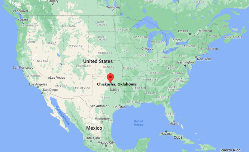
Where is Chickasha Located? - Chickasha is a city located in the Grady County of Oklahoma, United States. Chickasha lies between 35.3187279 Degrees North latitudes and 82.4609528 Degrees West longitudes.
Location Map of Chickasha, Oklahoma
Chickasha Map, Oklahoma, USA
Where is Chickasha?: The Google Map showing the location of Chickasha in the U.S. state of Oklahoma.
Where is Chickasha Located?
Chickasha is a city located in the Grady County of Oklahoma, United States. Chickasha lies between 35.3187279 Degrees North latitudes and 82.4609528 Degrees West longitudes. According to 2020 U.S.census, the population of Chickasha city is 16051 people and the city has a total area of 22.03 sq mi. The city has numerous parks and recreational facilities.
Transportation and Connectivity in Chickasha, Oklahoma
Transportation
Details
Airport Name
Chickasha Municipal Airport
IATA Code
No scheduled commercial service
Major Airport
Will Rogers World Airport
Major Highways
Interstate 44 (H.E. Bailey Turnpike), U.S. Route 62, U.S. Route 81, State Highway 19
Train Service
Freight rail service
Local Bus/Transit Service
Limited local and regional transit services
Interstate 44 (H.E. Bailey Turnpike) provides quick access to Oklahoma City, Lawton, and Wichita Falls, Texas.
Will Rogers World Airport in Oklahoma City is approximately 40 miles northeast and offers domestic commercial flights.
U.S. Highways 62 and 81 serve as major regional transportation routes through the city.
Freight rail service supports local agriculture, manufacturing, and industrial businesses.
Chickasha is known for its historic downtown, annual Festival of Light, educational institutions, and strong agricultural heritage in central Oklahoma.
Key Landmarks and Places to Visit in Chickasha, Oklahoma
Landmark Name
Type
Chickasha Festival of Light
Seasonal Attraction
Grady County Historical Society Museum
History Museum
University of Science and Arts of Oklahoma
University Campus
Shannon Springs Park
City Park
Chickasha Sports Complex
Sports Complex
Rock Island Depot Museum
Railroad Museum
Legends Pub House & Venue District
Entertainment Area
Washita Valley Park
Community Park
Red Rock Canyon Adventure Park
Nature Park
Fort Cobb State Park
State Park
Colleges and Universities in and near Chickasha, Oklahoma
Institution Name
Type
Level
Notable For
University of Science and Arts of Oklahoma
Public
University
Liberal arts, education, sciences, and performing arts
Canadian Valley Technology Center - Chickasha Campus
Public
Career & Technical School
Workforce development, healthcare, and skilled trades
Oklahoma City Community College
Public
Community College
Transfer programs, business, and technical education
University of Oklahoma
Public
University
Engineering, business, medicine, and research
Oklahoma State University - Oklahoma City
Public
University
Aviation, engineering technologies, and business
Waterbodies in Chickasha, Oklahoma
Washita River, Shannon Springs, Lake Chickasha, Fort Cobb Reservoir, Canadian River, Cobb Creek, Spring Creek, Line Creek
Golf Courses in and near Chickasha, Oklahoma
Chickasha Golf and Country Club, Winter Creek Golf & Social Club, River Oaks Golf Club, The Trails Golf Club, Earlywine Golf Club, KickingBird Golf Club, Cobblestone Creek Golf Club, Surrey Hills Golf Club
Chickasha, Oklahoma - Key Historical Facts
Chickasha was founded in 1892 following the arrival of the Rock Island Railroad through Indian Territory and quickly became a regional trade center.
The city's name comes from the Chickasaw Nation, reflecting the area's Native American heritage and historical significance.
Agriculture, cotton production, livestock, and rail transportation played major roles in Chickasha's early economic growth.
The University of Science and Arts of Oklahoma, established in 1908, has been an important educational institution for more than a century.
Over the years, Chickasha expanded its economy through manufacturing, energy, healthcare, and retail development while preserving its historic downtown.
Today, Chickasha is widely recognized for its annual Festival of Light, welcoming community, educational opportunities, and role as the commercial center of Grady County.