Written and Fact-checked by Whereig Editors, Reviewed by Mukesh Kumar| Updated On: May 15, 2026
Map of Grady County - Grady County is a county located in the U.S. state of Oklahoma. Grady County Map showing cities, highways, important places and water bodies. Get Where is Grady County located in the map, major cities in Grady county, population, areas, and places of interest.
Map of Grady County, Oklahoma
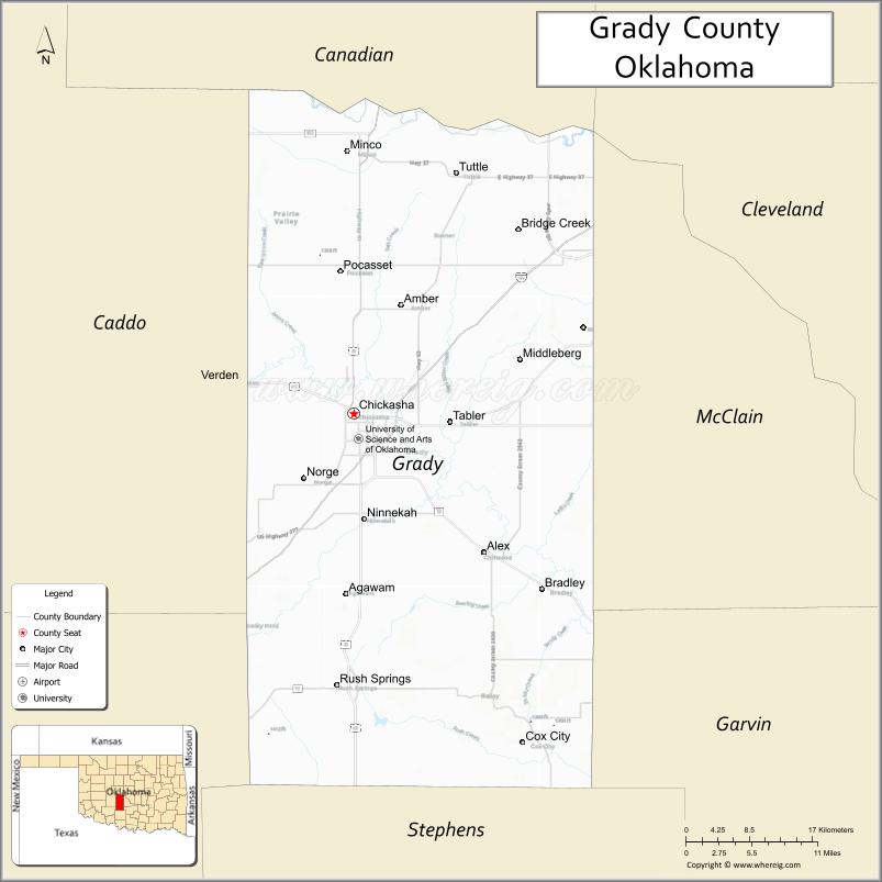
About Grady County Map, Oklahoma: The map showing the county boundary, county seat, major cities, highways, water bodies and neighbouring counties.
Related Oklahoma Maps
About Grady County, Oklahoma
Grady County is a county located in the U.S. state of Oklahoma. It's county seat is Chickasha. As per 2020 census, the population of Grady County is 55508 people and population density is 50.42 square miles. According to the United States Census Bureau, the county has a total area of 1,101 sq mi (2,852 km2). Grady County was established on 1907.
Grady County Facts
| Continent | North America |
| Country | United States |
| State | Oklahoma |
| County Seat | Chickasha |
| Largest City/Town | Chickasha |
| Established | 1907 |
| Total Area | 1,105 sq mi (2,862 sq km) |
| Land Area | 1,100 sq mi (2,849 sq km) |
| Water Area | 5 sq mi (13 sq km) |
| Population | 54,795 (Census 2020) |
| Population Density | 49.8 people per sq mi |
| Time Zone | Central Time Zone (CST/CDT) |
| Major Highways | Interstate 44, U.S. Route 62, U.S. Route 81, State Highway 19 |
| Major Rivers | Washita River, Canadian River nearby region |
| Neighboring Counties | Canadian County, McClain County, Garvin County, Stephens County, Caddo County, Comanche County |
| Famous For | Chickasha Festival of Light, agriculture, University of Science and Arts of Oklahoma, and south-central Oklahoma heritage |
| Top Attractions | Festival of Light, Grady County Historical Museum, Shannon Springs Park, and downtown Chickasha |
| Official Website | Official Website |
About Grady County, Oklahoma
Grady County is located in south-central Oklahoma and was established in 1907 from former Chickasaw Nation lands. The county seat and largest city is Chickasha. The county is known for agriculture, higher education, annual holiday light displays, and its location along major transportation corridors.
Cities and Towns in Grady County, Oklahoma
| City/Town | Population (Census 2020) | Latitude & Longitude |
|---|---|---|
| Chickasha (county seat) | 16,051 | 35.0526°N, 97.9364°W |
| Tuttle | 7,413 | 35.2912°N, 97.8128°W |
| Blanchard nearby region | 8,879 | 35.1370°N, 97.6581°W |
| Ninnekah | 1,011 | 34.9565°N, 97.9234°W |
| Rush Springs | 1,163 | 34.7820°N, 97.9578°W |
| Amber | 419 | 35.1617°N, 97.8789°W |
Golf Courses in Grady County, Oklahoma
| Golf Course | Location | Latitude & Longitude |
|---|---|---|
| Chickasha Golf & Country Club | Chickasha | 35.0675°N, 97.9516°W |
| Winter Creek Golf & Social Club | Tuttle nearby region | 35.3048°N, 97.8287°W |
| Shady Grove Golf Area | Rush Springs nearby region | 34.7926°N, 97.9691°W |
Major Roads and Highways in Grady County, Oklahoma
Major highways connect Grady County with Oklahoma City, Lawton, and south-central Oklahoma communities.
- Interstate 44 - major interstate linking Oklahoma City and southwestern Oklahoma
- U.S. Route 62 - important east-west transportation corridor
- U.S. Route 81 - major north-south highway through central Oklahoma
- State Highway 19 - regional highway serving rural and suburban communities
What are the Neighboring Counties of Grady County
- Canadian County (north)
- McClain County (east)
- Garvin County (southeast)
- Stephens County (south)
- Comanche County (southwest)
- Caddo County (west)
What are the Top Places to Visit in Grady County, Oklahoma
The county offers parks, museums, college events, and family-friendly recreation attractions.
- Chickasha Festival of Light - nationally known holiday light display and seasonal event
- Grady County Historical Museum - exhibits on pioneer and agricultural history
- Shannon Springs Park - walking trails, playgrounds, and outdoor recreation
- University of Science and Arts of Oklahoma - historic campus and cultural events
- Historic Downtown Chickasha - shopping, restaurants, and entertainment venues
- Washita Valley Park - sports facilities and community recreation
- Rush Springs Watermelon Festival - annual local celebration and agricultural tradition
- Fishing and Outdoor Recreation Areas - family activities and nature observation
- Scenic Countryside Drives - farmland and prairie photography opportunities
- Community Rodeos and Festivals - local entertainment and western heritage
What is the Distance from Grady County to Nearby Cities
The following distances are measured by road (driving).
- Chickasha to Oklahoma City (Oklahoma County), Oklahoma - 43 mi (69 km)
- Chickasha to Lawton (Comanche County), Oklahoma - 49 mi (79 km)
- Chickasha to Norman (Cleveland County), Oklahoma - 40 mi (64 km)
- Chickasha to Tuttle (Grady County), Oklahoma - 19 mi (31 km)
- Chickasha to Rush Springs (Grady County), Oklahoma - 27 mi (43 km)
- Chickasha to Tulsa (Tulsa County), Oklahoma - 139 mi (224 km)
- Chickasha to Dallas (Dallas County), Texas - 194 mi (312 km)
- Chickasha to Wichita (Sedgwick County), Kansas - 183 mi (294 km)
- Chickasha to Amarillo (Potter County), Texas - 259 mi (417 km)
- Chickasha to Kansas City (Jackson County), Missouri - 390 mi (628 km)
- Chickasha to Denver (Denver County), Colorado - 603 mi (970 km)
- Chickasha to Chicago (Cook County), Illinois - 844 mi (1,358 km)
FAQs about Grady County
Grady County is located in south-central Oklahoma.
Grady County had a population of 54,795 according to the 2020 United States Census.
Grady County is known for the Chickasha Festival of Light, agriculture, and the University of Science and Arts of Oklahoma.
The county is served by Interstate 44, U.S. Route 62, U.S. Route 81, and State Highway 19.
Yes, Grady County includes golf facilities such as Chickasha Golf & Country Club and Winter Creek Golf & Social Club.
References
- QuickFacts - U.S. Census Bureau
- United States Census Bureau
- United States Geological Survey (USGS)
- National Geodetic Survey
- Official Website
- Adair County Map
- Alfalfa County Map
- Atoka County Map
- Beaver County Map
- Beckham County Map
- Blaine County Map
- Bryan County Map
- Caddo County Map
- Canadian County Map
- Carter County Map
- Cherokee County Map
- Choctaw County Map
- Cimarron County Map
- Cleveland County Map
- Coal County Map
- Comanche County Map
- Cotton County Map
- Craig County Map
- Creek County Map
- Custer County Map
- Delaware County Map
- Dewey County Map
- Ellis County Map
- Garfield County Map
- Garvin County Map
- Grady County Map
- Grant County Map
- Greer County Map
- Harmon County Map
- Harper County Map
- Haskell County Map
- Hughes County Map
- Jackson County Map
- Jefferson County Map
- Johnston County Map
- Kay County Map
- Kingfisher County Map
- Kiowa County Map
- Latimer County Map
- Le Flore County Map
- Lincoln County Map
- Logan County Map
- Love County Map
- McClain County Map
- McCurtain County Map
- McIntosh County Map
- Major County Map
- Marshall County Map
- Mayes County Map
- Murray County Map
- Muskogee County Map
- Noble County Map
- Nowata County Map
- Okfuskee County Map
- Oklahoma County Map
- Okmulgee County Map
- Osage County Map
- Ottawa County Map
- Pawnee County Map
- Payne County Map
- Pittsburg County Map
- Pontotoc County Map
- Pottawatomie County Map
- Pushmataha County Map
- Roger Mills County Map
- Rogers County Map
- Seminole County Map
- Sequoyah County Map
- Stephens County Map
- Texas County Map
- Tillman County Map
- Tulsa County Map
- Wagoner County Map
- Washington County Map
- Washita County Map
- Woods County Map
- Woodward County Map
- Alabama Counties
- Alaska boroughs
- Arizona Counties
- Arkansas Counties
- California County Map
- Colorado Counties
- Connecticut Counties
- Delaware Counties
- Florida County Map
- Georgia County Map
- Hawaii Counties
- Idaho Counties
- Illinois Counties
- Indiana Counties
- Iowa Counties
- Kansas Counties
- Kentucky Counties
- Louisiana Counties
- Maine Counties
- Maryland Counties
- Massachusetts Counties
- Michigan County Map
- Minnesota Counties
- Mississippi Counties
- Missouri Counties
- Montana Counties
- Nebraska Counties
- Nevada Counties
- New York Counties
- New Hampshire Counties
- New Jersey Counties
- New Mexico Counties
- North Carolina Counties
- North Dakota Counties
- Ohio County Map
- Oklahoma Counties
- Oregon Counties
- Pennsylvania Counties
- Rhode Island Counties
- South Carolina Counties
- South Dakota Counties
- Map of Tennessee
- Texas County Map
- Utah Counties
- Vermont Counties
- Virginia Counties
- Washington Counties
- West Virginia Counties
- Wisconsin Counties
- Wyoming Counties