Written and Fact-checked by Whereig Editors, Reviewed by Mukesh Kumar| Updated On: May 15, 2026
Map of Washita County - Washita County is a county located in the U.S. state of Oklahoma. Washita County Map showing cities, highways, important places and water bodies. Get Where is Washita County located in the map, major cities in Washita county, population, areas, and places of interest.
Map of Washita County, Oklahoma
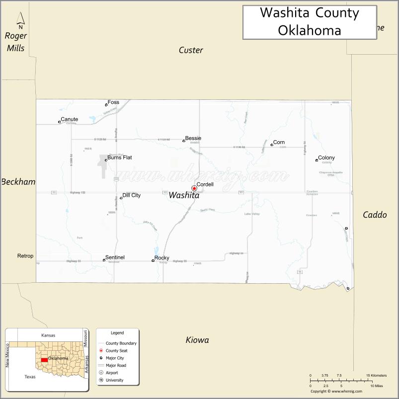
About Washita County Map, Oklahoma: The map showing the county boundary, county seat, major cities, highways, water bodies and neighbouring counties.
Related Oklahoma Maps
About Washita County, Oklahoma
Washita County is a county located in the U.S. state of Oklahoma. It's county seat is Cordell. As per 2020 census, the population of Washita County is 10915 people and population density is 10.87 square miles. According to the United States Census Bureau, the county has a total area of 1,004 sq mi (2,600 km2). Washita County was established on 1897.
Washita County Facts
| Continent | North America |
| Country | United States |
| State | Oklahoma |
| County Seat | Cordell |
| Largest City/Town | New Cordell |
| Established | 1891 |
| Total Area | 1,009 sq mi (2,613 sq km) |
| Land Area | 1,006 sq mi (2,606 sq km) |
| Water Area | 3 sq mi (8 sq km) |
| Population | 10,916 (Census 2020) |
| Population Density | 10.9 people per sq mi |
| Time Zone | Central Time Zone |
| Major Highways | Interstate 40, U.S. Highway 183, State Highway 44, State Highway 54, State Highway 55 |
| Major Rivers | Washita River |
| Neighboring Counties | Custer County, Caddo County, Kiowa County, Beckham County, Roger Mills County |
| Famous For | Farming, wheat production, Route 66 access, and western Oklahoma prairie landscapes |
| Top Attractions | Foss State Park, Washita Battlefield area, Cordell downtown historic district, and Foss Reservoir |
| Official Website | Official Website |
About Washita County, Oklahoma
Washita County is located in western Oklahoma and was established in 1891 during the early territorial period. The county seat is Cordell, while New Cordell is the county’s largest community. The county is known for its broad prairie landscapes, agricultural economy, and outdoor recreation areas centered around Foss Lake and the Washita River.
Cities and Towns in Washita County, Oklahoma
| City/Town | Population (Census 2020) | Latitude & Longitude |
|---|---|---|
| New Cordell (county seat) | 2,481 | 35.2906°N, 98.9881°W |
| Burns Flat | 1,146 | 35.3489°N, 99.1709°W |
| Canute | 428 | 35.4214°N, 99.2773°W |
| Cloud Chief | 57 | 35.1612°N, 98.9648°W |
| Corn | 436 | 35.3792°N, 98.7812°W |
| Dill City | 197 | 35.2753°N, 99.1392°W |
| Foss | 127 | 35.4461°N, 99.1700°W |
| Rocky | 495 | 35.1531°N, 99.0592°W |
| Sentinel | 718 | 35.1576°N, 99.1753°W |
| Weatherford (partly) | 12,148 | 35.5262°N, 98.7076°W |
Golf Courses in Washita County, Oklahoma
| Golf Course | Location | Latitude & Longitude |
|---|---|---|
| Cordell Country Club Golf Course | New Cordell | 35.2858°N, 98.9734°W |
| Sentinel Golf Club | Sentinel | 35.1509°N, 99.1738°W |
Major Roads and Highways in Washita County, Oklahoma
Major highways connect the county to nearby regions and cities.
- Interstate 40 - major east-west interstate connecting the county with Oklahoma City and Amarillo
- U.S. Highway 183 - north-south highway linking Cordell with Clinton and Hobart
- State Highway 44 - regional highway serving rural western communities
- State Highway 54 - connects Corn, Bessie, and neighboring agricultural areas
- State Highway 55 - route connecting Cordell with Foss Reservoir and surrounding towns
What are the Neighboring Counties of Washita County
- Custer County (north)
- Roger Mills County (northwest)
- Beckham County (west)
- Kiowa County (south)
- Caddo County (east)
What are the Top Places to Visit in Washita County, Oklahoma
The county offers a mix of natural and cultural attractions.
- Foss State Park - popular recreation area with camping, boating, and hiking near Foss Lake
- Foss Reservoir - large lake known for fishing, swimming, and water sports
- Washita Battlefield Area - historic region connected to Native American and frontier history
- Cordell Historic Downtown - area featuring historic buildings and local shops
- Washita County Courthouse - notable county landmark in New Cordell
- Canute Heritage Museum - small museum preserving local pioneer history
- Burns Flat Dinosaur Museum - regional attraction with fossil exhibits and educational displays
- Sentinel Community Park - local recreation and picnic area
- Prairie Heritage Scenic Drives - open countryside routes showcasing western Oklahoma landscapes
- Foss Dam Area - scenic location popular for birdwatching and outdoor photography
What is the Distance from Washita County to Nearby Cities
The following distances are measured by road (driving).
- New Cordell to Oklahoma City (Oklahoma County), Oklahoma - 106 mi (171 km)
- New Cordell to Clinton (Custer County), Oklahoma - 18 mi (29 km)
- New Cordell to Elk City (Beckham County), Oklahoma - 42 mi (68 km)
- New Cordell to Weatherford (Custer County), Oklahoma - 35 mi (56 km)
- New Cordell to Hobart (Kiowa County), Oklahoma - 29 mi (47 km)
- New Cordell to Lawton (Comanche County), Oklahoma - 79 mi (127 km)
- New Cordell to Amarillo (Potter County), Texas - 179 mi (288 km)
- New Cordell to Woodward (Woodward County), Oklahoma - 117 mi (188 km)
- New Cordell to Enid (Garfield County), Oklahoma - 125 mi (201 km)
- New Cordell to Altus (Jackson County), Oklahoma - 66 mi (106 km)
- New Cordell to Chickasha (Grady County), Oklahoma - 83 mi (134 km)
- New Cordell to Wichita Falls (Wichita County), Texas - 127 mi (204 km)
FAQs about Washita County
Washita County is located in western Oklahoma and is part of the Great Plains region.
The population of Washita County was 10,916 according to the Census 2020.
Washita County is known for agriculture, Foss Reservoir, prairie landscapes, and western Oklahoma history.
The county is served by Interstate 40, U.S. Highway 183, and several Oklahoma state highways.
Yes, Washita County has golf facilities including Cordell Country Club Golf Course and Sentinel Golf Club.
References
- QuickFacts - U.S. Census Bureau
- United States Census Bureau
- United States Geological Survey (USGS)
- National Geodetic Survey
- Official County Website
- Adair County Map
- Alfalfa County Map
- Atoka County Map
- Beaver County Map
- Beckham County Map
- Blaine County Map
- Bryan County Map
- Caddo County Map
- Canadian County Map
- Carter County Map
- Cherokee County Map
- Choctaw County Map
- Cimarron County Map
- Cleveland County Map
- Coal County Map
- Comanche County Map
- Cotton County Map
- Craig County Map
- Creek County Map
- Custer County Map
- Delaware County Map
- Dewey County Map
- Ellis County Map
- Garfield County Map
- Garvin County Map
- Grady County Map
- Grant County Map
- Greer County Map
- Harmon County Map
- Harper County Map
- Haskell County Map
- Hughes County Map
- Jackson County Map
- Jefferson County Map
- Johnston County Map
- Kay County Map
- Kingfisher County Map
- Kiowa County Map
- Latimer County Map
- Le Flore County Map
- Lincoln County Map
- Logan County Map
- Love County Map
- McClain County Map
- McCurtain County Map
- McIntosh County Map
- Major County Map
- Marshall County Map
- Mayes County Map
- Murray County Map
- Muskogee County Map
- Noble County Map
- Nowata County Map
- Okfuskee County Map
- Oklahoma County Map
- Okmulgee County Map
- Osage County Map
- Ottawa County Map
- Pawnee County Map
- Payne County Map
- Pittsburg County Map
- Pontotoc County Map
- Pottawatomie County Map
- Pushmataha County Map
- Roger Mills County Map
- Rogers County Map
- Seminole County Map
- Sequoyah County Map
- Stephens County Map
- Texas County Map
- Tillman County Map
- Tulsa County Map
- Wagoner County Map
- Washington County Map
- Washita County Map
- Woods County Map
- Woodward County Map
- Alabama Counties
- Alaska boroughs
- Arizona Counties
- Arkansas Counties
- California County Map
- Colorado Counties
- Connecticut Counties
- Delaware Counties
- Florida County Map
- Georgia County Map
- Hawaii Counties
- Idaho Counties
- Illinois Counties
- Indiana Counties
- Iowa Counties
- Kansas Counties
- Kentucky Counties
- Louisiana Counties
- Maine Counties
- Maryland Counties
- Massachusetts Counties
- Michigan County Map
- Minnesota Counties
- Mississippi Counties
- Missouri Counties
- Montana Counties
- Nebraska Counties
- Nevada Counties
- New York Counties
- New Hampshire Counties
- New Jersey Counties
- New Mexico Counties
- North Carolina Counties
- North Dakota Counties
- Ohio County Map
- Oklahoma Counties
- Oregon Counties
- Pennsylvania Counties
- Rhode Island Counties
- South Carolina Counties
- South Dakota Counties
- Map of Tennessee
- Texas County Map
- Utah Counties
- Vermont Counties
- Virginia Counties
- Washington Counties
- West Virginia Counties
- Wisconsin Counties
- Wyoming Counties