Written and Fact-checked by Whereig Editors, Reviewed by Mukesh Kumar| Updated On: May 15, 2026
Map of Pittsburg County - Pittsburg County is a county located in the U.S. state of Oklahoma. Pittsburg County Map showing cities, highways, important places and water bodies. Get Where is Pittsburg County located in the map, major cities in Pittsburg county, population, areas, and places of interest.
Map of Pittsburg County, Oklahoma
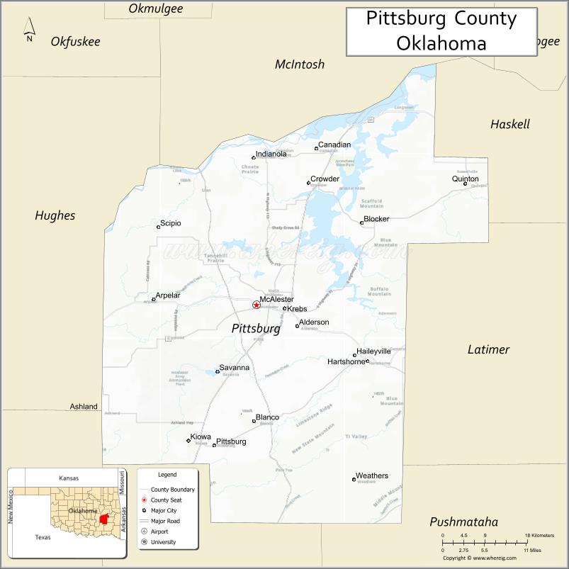
About Pittsburg County Map, Oklahoma: The map showing the county boundary, county seat, major cities, highways, water bodies and neighbouring counties.
Related Oklahoma Maps
About Pittsburg County, Oklahoma
Pittsburg County is a county located in the U.S. state of Oklahoma. It's county seat is McAlester. As per 2020 census, the population of Pittsburg County is 43633 people and population density is 33.41 square miles. According to the United States Census Bureau, the county has a total area of 1,306 sq mi (3,383 km2). Pittsburg County was established on 1907.
Pittsburg County Facts
| Continent | North America |
| Country | United States |
| State | Oklahoma |
| County Seat | McAlester |
| Largest City/Town | McAlester |
| Established | 1907 |
| Total Area | 1,378 sq mi (3,569 sq km) |
| Land Area | 1,305 sq mi (3,380 sq km) |
| Water Area | 73 sq mi (189 sq km) |
| Population | 43,773 (Census 2020) |
| Population Density | 33.5 people per sq mi |
| Time Zone | Central Time Zone (CST/CDT) |
| Major Highways | U.S. Route 69, U.S. Route 270, State Highway 31, Indian Nation Turnpike |
| Major Rivers | Canadian River, North Canadian River, Eufaula Lake nearby region |
| Neighboring Counties | Latimer County, Haskell County, McIntosh County, Hughes County, Pushmataha County |
| Famous For | Coal mining history, McAlester Army Ammunition Plant, Lake Eufaula recreation, and southeastern Oklahoma culture |
| Top Attractions | Lake Eufaula nearby region, Krebs dining district, McAlester attractions, and Robbers Cave nearby region |
| Official Website | Official Website |
About Pittsburg County, Oklahoma
Pittsburg County is located in southeastern Oklahoma and was established in 1907 from former Choctaw Nation territory. The county seat and largest city is McAlester. The county is known for coal mining heritage, outdoor recreation, Italian restaurants in Krebs, and scenic lake and hill country landscapes.
Cities and Towns in Pittsburg County, Oklahoma
| City/Town | Population (Census 2020) | Latitude & Longitude |
|---|---|---|
| McAlester (county seat) | 18,363 | 34.9334°N, 95.7697°W |
| Krebs | 2,053 | 34.9270°N, 95.7141°W |
| Hartshorne | 1,891 | 34.8462°N, 95.5578°W |
| Canadian | 220 | 35.1717°N, 95.6605°W |
| Kiowa | 656 | 34.7201°N, 95.8991°W |
| Quinton | 765 | 35.1245°N, 95.3697°W |
Golf Courses in Pittsburg County, Oklahoma
| Golf Course | Location | Latitude & Longitude |
|---|---|---|
| McAlester Country Club | McAlester | 34.9191°N, 95.7954°W |
| Arrowhead State Park Golf Course | Lake Eufaula nearby region | 35.1335°N, 95.6618°W |
| Krebs Community Golf Area | Krebs nearby region | 34.9358°N, 95.7234°W |
Major Roads and Highways in Pittsburg County, Oklahoma
Major highways connect Pittsburg County with southeastern Oklahoma recreation areas and regional cities.
- U.S. Route 69 - major north-south transportation corridor
- U.S. Route 270 - important east-west regional highway
- State Highway 31 - route serving rural and recreational communities
- Indian Nation Turnpike - toll highway linking central and southeastern Oklahoma
What are the Neighboring Counties of Pittsburg County
- Hughes County (northwest)
- McIntosh County (north)
- Haskell County (east)
- Latimer County (southeast)
- Pushmataha County (south)
What are the Top Places to Visit in Pittsburg County, Oklahoma
The county offers lakes, parks, restaurants, museums, and outdoor recreation opportunities.
- Lake Eufaula nearby region - boating, fishing, camping, and waterfront recreation
- Krebs Dining District - famous Italian restaurants and cultural attractions
- Robbers Cave State Park nearby region - hiking, climbing, and outdoor adventures
- Historic Downtown McAlester - local shops, museums, and restaurants
- Arrowhead State Park - golf, camping, trails, and lake recreation
- Choctaw Nation Heritage Sites nearby region - Native American culture and history
- Fishing and Wildlife Areas - birdwatching and outdoor exploration
- Community Rodeos and Festivals - seasonal entertainment and local traditions
- Scenic Hill Country Drives - photography and countryside landscapes
- Nature Trails and Recreation Areas - hiking and environmental education
What is the Distance from Pittsburg County to Nearby Cities
The following distances are measured by road (driving).
- McAlester to Muskogee (Muskogee County), Oklahoma - 68 mi (109 km)
- McAlester to Tulsa (Tulsa County), Oklahoma - 118 mi (190 km)
- McAlester to Oklahoma City (Oklahoma County), Oklahoma - 131 mi (211 km)
- McAlester to Krebs (Pittsburg County), Oklahoma - 3 mi (5 km)
- McAlester to Hartshorne (Pittsburg County), Oklahoma - 17 mi (27 km)
- McAlester to Fort Smith (Sebastian County), Arkansas - 104 mi (167 km)
- McAlester to Dallas (Dallas County), Texas - 196 mi (315 km)
- McAlester to Little Rock (Pulaski County), Arkansas - 212 mi (341 km)
- McAlester to Kansas City (Jackson County), Missouri - 283 mi (455 km)
- McAlester to Amarillo (Potter County), Texas - 396 mi (637 km)
- McAlester to Denver (Denver County), Colorado - 678 mi (1,091 km)
- McAlester to Chicago (Cook County), Illinois - 651 mi (1,048 km)
- McAlester to Atlanta (Fulton County), Georgia - 731 mi (1,176 km)
FAQs about Pittsburg County
Pittsburg County is located in southeastern Oklahoma.
Pittsburg County had a population of 43,773 according to the 2020 United States Census.
Pittsburg County is known for coal mining history, Italian restaurants in Krebs, outdoor recreation, and scenic lake areas.
The county is served by U.S. Route 69, U.S. Route 270, State Highway 31, and the Indian Nation Turnpike.
Yes, Pittsburg County includes golf facilities such as McAlester Country Club and Arrowhead State Park Golf Course.
References
- QuickFacts - U.S. Census Bureau
- United States Census Bureau
- United States Geological Survey (USGS)
- National Geodetic Survey
- Official Website
- Adair County Map
- Alfalfa County Map
- Atoka County Map
- Beaver County Map
- Beckham County Map
- Blaine County Map
- Bryan County Map
- Caddo County Map
- Canadian County Map
- Carter County Map
- Cherokee County Map
- Choctaw County Map
- Cimarron County Map
- Cleveland County Map
- Coal County Map
- Comanche County Map
- Cotton County Map
- Craig County Map
- Creek County Map
- Custer County Map
- Delaware County Map
- Dewey County Map
- Ellis County Map
- Garfield County Map
- Garvin County Map
- Grady County Map
- Grant County Map
- Greer County Map
- Harmon County Map
- Harper County Map
- Haskell County Map
- Hughes County Map
- Jackson County Map
- Jefferson County Map
- Johnston County Map
- Kay County Map
- Kingfisher County Map
- Kiowa County Map
- Latimer County Map
- Le Flore County Map
- Lincoln County Map
- Logan County Map
- Love County Map
- McClain County Map
- McCurtain County Map
- McIntosh County Map
- Major County Map
- Marshall County Map
- Mayes County Map
- Murray County Map
- Muskogee County Map
- Noble County Map
- Nowata County Map
- Okfuskee County Map
- Oklahoma County Map
- Okmulgee County Map
- Osage County Map
- Ottawa County Map
- Pawnee County Map
- Payne County Map
- Pittsburg County Map
- Pontotoc County Map
- Pottawatomie County Map
- Pushmataha County Map
- Roger Mills County Map
- Rogers County Map
- Seminole County Map
- Sequoyah County Map
- Stephens County Map
- Texas County Map
- Tillman County Map
- Tulsa County Map
- Wagoner County Map
- Washington County Map
- Washita County Map
- Woods County Map
- Woodward County Map
- Alabama Counties
- Alaska boroughs
- Arizona Counties
- Arkansas Counties
- California County Map
- Colorado Counties
- Connecticut Counties
- Delaware Counties
- Florida County Map
- Georgia County Map
- Hawaii Counties
- Idaho Counties
- Illinois Counties
- Indiana Counties
- Iowa Counties
- Kansas Counties
- Kentucky Counties
- Louisiana Counties
- Maine Counties
- Maryland Counties
- Massachusetts Counties
- Michigan County Map
- Minnesota Counties
- Mississippi Counties
- Missouri Counties
- Montana Counties
- Nebraska Counties
- Nevada Counties
- New York Counties
- New Hampshire Counties
- New Jersey Counties
- New Mexico Counties
- North Carolina Counties
- North Dakota Counties
- Ohio County Map
- Oklahoma Counties
- Oregon Counties
- Pennsylvania Counties
- Rhode Island Counties
- South Carolina Counties
- South Dakota Counties
- Map of Tennessee
- Texas County Map
- Utah Counties
- Vermont Counties
- Virginia Counties
- Washington Counties
- West Virginia Counties
- Wisconsin Counties
- Wyoming Counties