Written and Fact-checked by Whereig Editors, Reviewed by Mukesh Kumar| Updated On: May 15, 2026
Map of Marshall County - Marshall County is a county located in the U.S. state of Oklahoma. Marshall County Map showing cities, highways, important places and water bodies. Get Where is Marshall County located in the map, major cities in Marshall county, population, areas, and places of interest.
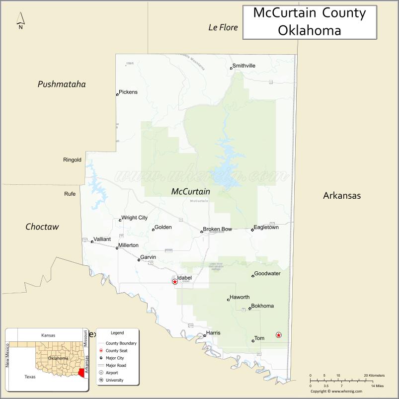
Map of McCurtain County, Oklahoma
About Marshall County Map, Oklahoma: The map showing the county boundary, county seat, major cities, highways, water bodies and neighbouring counties.
Related Oklahoma Maps
About McCurtain County, Oklahoma
McCurtain County is a county located in the U.S. state of Oklahoma. It's county seat is Idabel. As per 2020 census, the population of McCurtain County is 30884 people and population density is 16.68 square miles. According to the United States Census Bureau, the county has a total area of 1,852 sq mi (4,797 km2). McCurtain County was established on 1907.
McCurtain County Facts
| Continent | North America |
| Country | United States |
| State | Oklahoma |
| County Seat | Idabel |
| Largest City/Town | Idabel |
| Established | 1907 |
| Total Area | 1,902 sq mi (4,926 sq km) |
| Land Area | 1,850 sq mi (4,792 sq km) |
| Water Area | 52 sq mi (135 sq km) |
| Population | 30,814 (Census 2020) |
| Population Density | 16.7 people per sq mi |
| Time Zone | Central Time Zone (CST/CDT) |
| Major Highways | U.S. Route 70, U.S. Route 259, State Highway 3 |
| Major Rivers | Mountain Fork River, Little River, Red River nearby region |
| Neighboring Counties | Le Flore County, Pushmataha County, Choctaw County, Sevier County (Arkansas), Little River County (Arkansas), Bowie County (Texas) |
| Famous For | Beavers Bend State Park, Broken Bow Lake, forestry, and Ouachita Mountain recreation |
| Top Attractions | Beavers Bend State Park, Broken Bow Lake, Hochatown, and Mountain Fork River recreation |
| Official Website | Official Website |
About McCurtain County, Oklahoma
McCurtain County is located in southeastern Oklahoma and was established in 1907 from former Choctaw Nation territory. The county seat and largest city is Idabel. The county is known for forests, mountain scenery, tourism, outdoor recreation, and popular destinations around Broken Bow Lake and Beavers Bend State Park.
Cities and Towns in McCurtain County, Oklahoma
| City/Town | Population (Census 2020) | Latitude & Longitude |
|---|---|---|
| Idabel (county seat) | 6,951 | 33.8957°N, 94.8263°W |
| Broken Bow | 4,311 | 34.0293°N, 94.7391°W |
| Valliant | 771 | 34.0029°N, 95.0936°W |
| Eagletown | 404 | 33.9379°N, 94.5727°W |
| Haworth | 253 | 33.8471°N, 94.6541°W |
| Garvin nearby region | 256 | 33.9526°N, 94.9381°W |
Golf Courses in McCurtain County, Oklahoma
| Golf Course | Location | Latitude & Longitude |
|---|---|---|
| Cedar Creek Golf Course | Broken Bow nearby region | 34.1347°N, 94.7005°W |
| Idabel Country Club | Idabel | 33.9076°N, 94.8428°W |
| Hochatown Recreation Golf Area | Hochatown nearby region | 34.1495°N, 94.7419°W |
Major Roads and Highways in McCurtain County, Oklahoma
Major highways connect McCurtain County with southeastern Oklahoma tourism destinations and neighboring states.
- U.S. Route 70 - major east-west transportation corridor across southern Oklahoma
- U.S. Route 259 - important north-south route serving recreation areas
- State Highway 3 - scenic highway connecting southeastern Oklahoma communities
What are the Neighboring Counties of McCurtain County
- Le Flore County (north)
- Pushmataha County (west)
- Choctaw County (southwest)
- Sevier County, Arkansas (east)
- Little River County, Arkansas (southeast)
- Bowie County, Texas (south)
What are the Top Places to Visit in McCurtain County, Oklahoma
The county offers forests, lakes, rivers, cabins, and outdoor recreation opportunities.
- Beavers Bend State Park - hiking, camping, fishing, kayaking, and cabin rentals
- Broken Bow Lake - boating, swimming, fishing, and scenic mountain recreation
- Hochatown - tourism destination with cabins, wineries, and outdoor activities
- Mountain Fork River - trout fishing, canoeing, and kayaking recreation
- Ouachita National Forest nearby region - hiking and wildlife viewing opportunities
- Historic Downtown Idabel - local museums, restaurants, and cultural attractions
- Fishing and Wildlife Areas - birdwatching and outdoor exploration
- Scenic Mountain Drives - photography and forest landscapes
- Camping and RV Parks - vacation destinations and outdoor family recreation
- Nature Trails and Adventure Activities - ziplining, hiking, and environmental education
What is the Distance from McCurtain County to Nearby Cities
The following distances are measured by road (driving).
- Idabel to Broken Bow (McCurtain County), Oklahoma - 15 mi (24 km)
- Idabel to Texarkana (Bowie County), Texas - 72 mi (116 km)
- Idabel to Paris (Lamar County), Texas - 86 mi (138 km)
- Idabel to Fort Smith (Sebastian County), Arkansas - 114 mi (183 km)
- Idabel to Hochatown nearby region - 28 mi (45 km)
- Idabel to Valliant (McCurtain County), Oklahoma - 18 mi (29 km)
- Idabel to Little Rock (Pulaski County), Arkansas - 183 mi (295 km)
- Idabel to Dallas (Dallas County), Texas - 196 mi (315 km)
- Idabel to Tulsa (Tulsa County), Oklahoma - 235 mi (378 km)
- Idabel to Oklahoma City (Oklahoma County), Oklahoma - 228 mi (367 km)
- Idabel to Kansas City (Jackson County), Missouri - 430 mi (692 km)
- Idabel to Amarillo (Potter County), Texas - 434 mi (698 km)
- Idabel to Denver (Denver County), Colorado - 774 mi (1,246 km)
FAQs about McCurtain County
McCurtain County is located in southeastern Oklahoma.
McCurtain County had a population of 30,814 according to the 2020 United States Census.
McCurtain County is known for Beavers Bend State Park, Broken Bow Lake, forestry, and mountain recreation.
The county is served by U.S. Route 70, U.S. Route 259, and State Highway 3.
Yes, McCurtain County includes golf facilities near Broken Bow, Hochatown, and Idabel.
References
- QuickFacts - U.S. Census Bureau
- United States Census Bureau
- United States Geological Survey (USGS)
- National Geodetic Survey
- Official Website
- Adair County Map
- Alfalfa County Map
- Atoka County Map
- Beaver County Map
- Beckham County Map
- Blaine County Map
- Bryan County Map
- Caddo County Map
- Canadian County Map
- Carter County Map
- Cherokee County Map
- Choctaw County Map
- Cimarron County Map
- Cleveland County Map
- Coal County Map
- Comanche County Map
- Cotton County Map
- Craig County Map
- Creek County Map
- Custer County Map
- Delaware County Map
- Dewey County Map
- Ellis County Map
- Garfield County Map
- Garvin County Map
- Grady County Map
- Grant County Map
- Greer County Map
- Harmon County Map
- Harper County Map
- Haskell County Map
- Hughes County Map
- Jackson County Map
- Jefferson County Map
- Johnston County Map
- Kay County Map
- Kingfisher County Map
- Kiowa County Map
- Latimer County Map
- Le Flore County Map
- Lincoln County Map
- Logan County Map
- Love County Map
- McClain County Map
- McCurtain County Map
- McIntosh County Map
- Major County Map
- Marshall County Map
- Mayes County Map
- Murray County Map
- Muskogee County Map
- Noble County Map
- Nowata County Map
- Okfuskee County Map
- Oklahoma County Map
- Okmulgee County Map
- Osage County Map
- Ottawa County Map
- Pawnee County Map
- Payne County Map
- Pittsburg County Map
- Pontotoc County Map
- Pottawatomie County Map
- Pushmataha County Map
- Roger Mills County Map
- Rogers County Map
- Seminole County Map
- Sequoyah County Map
- Stephens County Map
- Texas County Map
- Tillman County Map
- Tulsa County Map
- Wagoner County Map
- Washington County Map
- Washita County Map
- Woods County Map
- Woodward County Map
- Alabama Counties
- Alaska boroughs
- Arizona Counties
- Arkansas Counties
- California County Map
- Colorado Counties
- Connecticut Counties
- Delaware Counties
- Florida County Map
- Georgia County Map
- Hawaii Counties
- Idaho Counties
- Illinois Counties
- Indiana Counties
- Iowa Counties
- Kansas Counties
- Kentucky Counties
- Louisiana Counties
- Maine Counties
- Maryland Counties
- Massachusetts Counties
- Michigan County Map
- Minnesota Counties
- Mississippi Counties
- Missouri Counties
- Montana Counties
- Nebraska Counties
- Nevada Counties
- New York Counties
- New Hampshire Counties
- New Jersey Counties
- New Mexico Counties
- North Carolina Counties
- North Dakota Counties
- Ohio County Map
- Oklahoma Counties
- Oregon Counties
- Pennsylvania Counties
- Rhode Island Counties
- South Carolina Counties
- South Dakota Counties
- Map of Tennessee
- Texas County Map
- Utah Counties
- Vermont Counties
- Virginia Counties
- Washington Counties
- West Virginia Counties
- Wisconsin Counties
- Wyoming Counties