Written and Fact-checked by Whereig Editors, Reviewed by Mukesh Kumar| Updated On: May 15, 2026
Map of Woods County - Woods County is a county located in the U.S. state of Oklahoma. Woods County Map showing cities, highways, important places and water bodies. Get Where is Woods County located in the map, major cities in Woods county, population, areas, and places of interest.
Map of Woods County, Oklahoma
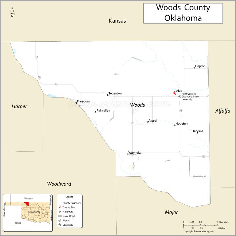
About Woods County Map, Oklahoma: The map showing the county boundary, county seat, major cities, highways, water bodies and neighbouring counties.
Related Oklahoma Maps
About Woods County, Oklahoma
Woods County is a county located in the U.S. state of Oklahoma. It's county seat is Alva. As per 2020 census, the population of Woods County is 8583 people and population density is 6.67 square miles. According to the United States Census Bureau, the county has a total area of 1,287 sq mi (3,333 km2). Woods County was established on 1893.
Woods County Facts
| Continent | North America |
| Country | United States |
| State | Oklahoma |
| County Seat | Alva |
| Largest City/Town | Alva |
| Established | 1893 |
| Total Area | 1,290 sq mi (3,341 sq km) |
| Land Area | 1,286 sq mi (3,331 sq km) |
| Water Area | 4 sq mi (10 sq km) |
| Population | 8,788 (Census 2020) |
| Population Density | 6.8 people per sq mi |
| Time Zone | Central Time Zone |
| Major Highways | U.S. Highway 64, U.S. Highway 281, State Highway 14, State Highway 34 |
| Major Rivers | Cimarron River, Salt Fork Arkansas River |
| Neighboring Counties | Harper County, Alfalfa County, Major County, Woodward County, Barber County (Kansas), Comanche County (Kansas) |
| Famous For | Northwestern Oklahoma State University, ranching, wheat farming, and Great Plains scenery |
| Top Attractions | Alabaster Caverns State Park, Northwestern Oklahoma State University, Little Sahara Sand Dunes nearby, and downtown Alva |
| Official Website | Official Website |
About Woods County, Oklahoma
Woods County is located in northwestern Oklahoma near the Kansas border and was established in 1893 during the Cherokee Outlet land opening. The county seat is Alva, which is also the largest city and home to Northwestern Oklahoma State University. The county features open prairie landscapes, agricultural land, and scenic areas shaped by the Cimarron River and Great Plains terrain.
Cities and Towns in Woods County, Oklahoma
| City/Town | Population (Census 2020) | Latitude & Longitude |
|---|---|---|
| Alva (county seat) | 4,855 | 36.8050°N, 98.6665°W |
| Waynoka | 738 | 36.5825°N, 98.8798°W |
| Freedom | 247 | 36.7667°N, 99.1112°W |
| Dacoma | 107 | 36.6650°N, 98.5615°W |
| Capron | 23 | 36.9025°N, 98.6256°W |
| Avard | 31 | 36.7725°N, 98.7884°W |
Golf Courses in Woods County, Oklahoma
| Golf Course | Location | Latitude & Longitude |
|---|---|---|
| Alva Golf and Country Club | Alva | 36.7912°N, 98.6557°W |
| Waynoka Municipal Golf Course | Waynoka | 36.5790°N, 98.8755°W |
Major Roads and Highways in Woods County, Oklahoma
Major highways connect the county to nearby regions and cities.
- U.S. Highway 64 - east-west highway connecting Alva with Enid and Guymon
- U.S. Highway 281 - north-south route linking Woods County with Kansas and central Oklahoma
- State Highway 14 - serves communities including Alva and Waynoka
- State Highway 34 - connects rural western areas with Woodward and Harper counties
What are the Neighboring Counties of Woods County
- Comanche County, Kansas (north)
- Barber County, Kansas (northeast)
- Alfalfa County (east)
- Major County (southeast)
- Woodward County (southwest)
- Harper County (west)
What are the Top Places to Visit in Woods County, Oklahoma
The county offers a mix of natural and cultural attractions.
- Alabaster Caverns State Park - famous gypsum cave system and hiking destination near Freedom
- Northwestern Oklahoma State University - historic university campus in Alva
- Little Sahara State Park - nearby sand dune recreation area popular for off-road vehicles
- Downtown Alva - historic district with shops, restaurants, and murals
- Waynoka Air Rail Museum - local museum focused on railroad and aviation history
- Hatfield Park - public park in Alva with sports facilities and picnic areas
- Salt Plains and Prairie Scenic Drives - open countryside routes with Great Plains views
- Freedom Rodeo Grounds - venue hosting annual rodeo and western heritage events
- Cimarron River Access Areas - fishing, wildlife viewing, and outdoor recreation spots
- Alva Recreational Complex - community center with trails and sports amenities
What is the Distance from Woods County to Nearby Cities
The following distances are measured by road (driving).
- Alva to Enid (Garfield County), Oklahoma - 86 mi (138 km)
- Alva to Woodward (Woodward County), Oklahoma - 55 mi (89 km)
- Alva to Stillwater (Payne County), Oklahoma - 153 mi (246 km)
- Alva to Oklahoma City (Oklahoma County), Oklahoma - 170 mi (274 km)
- Alva to Wichita (Sedgwick County), Kansas - 137 mi (220 km)
- Alva to Dodge City (Ford County), Kansas - 146 mi (235 km)
- Alva to Guymon (Texas County), Oklahoma - 165 mi (266 km)
- Alva to Ponca City (Kay County), Oklahoma - 106 mi (171 km)
- Alva to Liberal (Seward County), Kansas - 112 mi (180 km)
- Alva to Elk City (Beckham County), Oklahoma - 146 mi (235 km)
- Alva to Tulsa (Tulsa County), Oklahoma - 244 mi (393 km)
- Alva to Great Bend (Barton County), Kansas - 150 mi (241 km)
FAQs about Woods County
Woods County is located in northwestern Oklahoma near the Kansas border.
The population of Woods County was 8,788 according to the Census 2020.
Woods County is known for Northwestern Oklahoma State University, ranching, wheat farming, and Alabaster Caverns State Park.
The county is served by U.S. Highway 64, U.S. Highway 281, State Highway 14, and State Highway 34.
Yes, Woods County has golf facilities including Alva Golf and Country Club and Waynoka Municipal Golf Course.
References
- QuickFacts - U.S. Census Bureau
- United States Census Bureau
- United States Geological Survey (USGS)
- National Geodetic Survey
- Official County Website
- Adair County Map
- Alfalfa County Map
- Atoka County Map
- Beaver County Map
- Beckham County Map
- Blaine County Map
- Bryan County Map
- Caddo County Map
- Canadian County Map
- Carter County Map
- Cherokee County Map
- Choctaw County Map
- Cimarron County Map
- Cleveland County Map
- Coal County Map
- Comanche County Map
- Cotton County Map
- Craig County Map
- Creek County Map
- Custer County Map
- Delaware County Map
- Dewey County Map
- Ellis County Map
- Garfield County Map
- Garvin County Map
- Grady County Map
- Grant County Map
- Greer County Map
- Harmon County Map
- Harper County Map
- Haskell County Map
- Hughes County Map
- Jackson County Map
- Jefferson County Map
- Johnston County Map
- Kay County Map
- Kingfisher County Map
- Kiowa County Map
- Latimer County Map
- Le Flore County Map
- Lincoln County Map
- Logan County Map
- Love County Map
- McClain County Map
- McCurtain County Map
- McIntosh County Map
- Major County Map
- Marshall County Map
- Mayes County Map
- Murray County Map
- Muskogee County Map
- Noble County Map
- Nowata County Map
- Okfuskee County Map
- Oklahoma County Map
- Okmulgee County Map
- Osage County Map
- Ottawa County Map
- Pawnee County Map
- Payne County Map
- Pittsburg County Map
- Pontotoc County Map
- Pottawatomie County Map
- Pushmataha County Map
- Roger Mills County Map
- Rogers County Map
- Seminole County Map
- Sequoyah County Map
- Stephens County Map
- Texas County Map
- Tillman County Map
- Tulsa County Map
- Wagoner County Map
- Washington County Map
- Washita County Map
- Woods County Map
- Woodward County Map
- Alabama Counties
- Alaska boroughs
- Arizona Counties
- Arkansas Counties
- California County Map
- Colorado Counties
- Connecticut Counties
- Delaware Counties
- Florida County Map
- Georgia County Map
- Hawaii Counties
- Idaho Counties
- Illinois Counties
- Indiana Counties
- Iowa Counties
- Kansas Counties
- Kentucky Counties
- Louisiana Counties
- Maine Counties
- Maryland Counties
- Massachusetts Counties
- Michigan County Map
- Minnesota Counties
- Mississippi Counties
- Missouri Counties
- Montana Counties
- Nebraska Counties
- Nevada Counties
- New York Counties
- New Hampshire Counties
- New Jersey Counties
- New Mexico Counties
- North Carolina Counties
- North Dakota Counties
- Ohio County Map
- Oklahoma Counties
- Oregon Counties
- Pennsylvania Counties
- Rhode Island Counties
- South Carolina Counties
- South Dakota Counties
- Map of Tennessee
- Texas County Map
- Utah Counties
- Vermont Counties
- Virginia Counties
- Washington Counties
- West Virginia Counties
- Wisconsin Counties
- Wyoming Counties