Written and Fact-checked by Whereig Editors, Reviewed by Mukesh Kumar| Updated On: May 15, 2026
Map of Beckham County - Beckham County is a county located in the U.S. state of Oklahoma. Beckham County Map showing cities, highways, important places and water bodies. Get Where is Beckham County located in the map, major cities in Beckham county, population, areas, and places of interest.
Map of Beckham County, Oklahoma
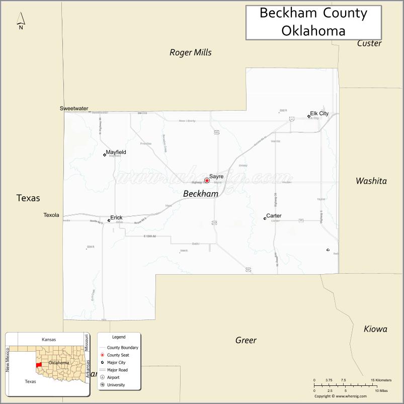
About Beckham County Map, Oklahoma: The map showing the county boundary, county seat, major cities, highways, water bodies and neighbouring counties.
Related Oklahoma Maps
About Beckham County, Oklahoma
Beckham County is a county located in the U.S. state of Oklahoma. It's county seat is Sayre. As per 2020 census, the population of Beckham County is 22046 people and population density is 24.44 square miles. According to the United States Census Bureau, the county has a total area of 902 sq mi (2,336 km2). Beckham County was established on 1907.
Beckham County Facts
| Continent | North America |
| Country | United States |
| State | Oklahoma |
| County Seat | Sayre |
| Largest City/Town | Elk City |
| Established | 1907 |
| Total Area | 902 sq mi (2,336 sq km) |
| Land Area | 900 sq mi (2,331 sq km) |
| Water Area | 2 sq mi (5 sq km) |
| Population | 22,140 (Census 2020) |
| Population Density | 24.6 people per sq mi |
| Time Zone | Central Time Zone (CST/CDT) |
| Major Highways | Interstate 40, U.S. Route 66 historic route, U.S. Route 283, State Highway 6 |
| Major Rivers | North Fork Red River, Elk Creek |
| Neighboring Counties | Roger Mills County, Washita County, Greer County, Harmon County, Collingsworth County (Texas) |
| Famous For | Historic Route 66, western Oklahoma heritage, energy production, and prairie landscapes |
| Top Attractions | National Route 66 Museum, Elk City Lake, Sayre Historic District, and western Oklahoma recreation areas |
| Official Website | Official Website |
About Beckham County, Oklahoma
Beckham County is located in western Oklahoma along the historic Route 66 corridor and was established in 1907. The county seat is Sayre, while Elk City is the largest city and commercial center. The county is known for transportation history, ranching, agriculture, energy production, and western prairie scenery.
Cities and Towns in Beckham County, Oklahoma
| City/Town | Population (Census 2020) | Latitude & Longitude |
|---|---|---|
| Elk City | 11,652 | 35.4119°N, 99.4043°W |
| Sayre (county seat) | 4,643 | 35.2906°N, 99.6401°W |
| Erick | 1,047 | 35.2159°N, 99.8665°W |
| Carter | 248 | 35.2209°N, 99.5076°W |
| Texola | 42 | 35.2214°N, 100.0055°W |
| Delhi nearby region | 915 | 35.2787°N, 99.4992°W |
Golf Courses in Beckham County, Oklahoma
| Golf Course | Location | Latitude & Longitude |
|---|---|---|
| Elk City Golf & Country Club | Elk City | 35.4208°N, 99.4197°W |
| Sayre Golf Course | Sayre | 35.3011°N, 99.6514°W |
| Western Plains Recreation Golf Area | Erick nearby region | 35.2252°N, 99.8771°W |
Major Roads and Highways in Beckham County, Oklahoma
Major highways connect Beckham County with western Oklahoma, Texas, and the historic Route 66 corridor.
- Interstate 40 - major east-west interstate highway across Oklahoma
- Historic U.S. Route 66 - famous historic highway through Elk City and Erick
- U.S. Route 283 - north-south transportation route through western Oklahoma
- State Highway 6 - regional connector serving rural communities
What are the Neighboring Counties of Beckham County
- Roger Mills County (north)
- Washita County (east)
- Greer County (south)
- Harmon County (southwest)
- Collingsworth County, Texas (west)
What are the Top Places to Visit in Beckham County, Oklahoma
The county offers Route 66 history, prairie recreation, lakes, and western Oklahoma heritage attractions.
- National Route 66 Museum - historic exhibits, classic Americana, and transportation history
- Elk City Lake - boating, fishing, camping, and outdoor recreation
- Sayre Historic District - preserved architecture and local heritage attractions
- Historic Route 66 Attractions - roadside landmarks and classic travel stops
- Western Oklahoma Scenic Drives - prairie landscapes and countryside photography
- Community Rodeos and Festivals - local traditions and western entertainment
- Hunting and Wildlife Areas - deer hunting and birdwatching activities
- Old Town Museum Complex in Elk City - pioneer history and recreated historic village
- Camping and RV Parks - family recreation and road-trip destinations
- Nature Observation Areas - prairie wildlife and environmental exploration
What is the Distance from Beckham County to Nearby Cities
The following distances are measured by road (driving).
- Elk City to Oklahoma City (Oklahoma County), Oklahoma - 110 mi (177 km)
- Elk City to Amarillo (Potter County), Texas - 138 mi (222 km)
- Elk City to Lawton (Comanche County), Oklahoma - 112 mi (180 km)
- Elk City to Clinton (Custer County), Oklahoma - 43 mi (69 km)
- Elk City to Sayre (Beckham County), Oklahoma - 15 mi (24 km)
- Elk City to Erick (Beckham County), Oklahoma - 37 mi (60 km)
- Elk City to Tulsa (Tulsa County), Oklahoma - 225 mi (362 km)
- Elk City to Wichita Falls (Wichita County), Texas - 178 mi (286 km)
- Elk City to Dallas (Dallas County), Texas - 289 mi (465 km)
- Elk City to Albuquerque (Bernalillo County), New Mexico - 343 mi (552 km)
- Elk City to Kansas City (Jackson County), Missouri - 423 mi (681 km)
- Elk City to Denver (Denver County), Colorado - 455 mi (732 km)
- Elk City to Chicago (Cook County), Illinois - 844 mi (1,358 km)
FAQs about Beckham County
Beckham County is located in western Oklahoma along the historic Route 66 corridor.
Beckham County had a population of 22,140 according to the 2020 United States Census.
Beckham County is known for Route 66 history, prairie landscapes, agriculture, and energy production.
The county is served by Interstate 40, Historic U.S. Route 66, U.S. Route 283, and State Highway 6.
Yes, Beckham County includes golf facilities such as Elk City Golf & Country Club and Sayre Golf Course.
References
- QuickFacts - U.S. Census Bureau
- United States Census Bureau
- United States Geological Survey (USGS)
- National Geodetic Survey
- Official Website
- Adair County Map
- Alfalfa County Map
- Atoka County Map
- Beaver County Map
- Beckham County Map
- Blaine County Map
- Bryan County Map
- Caddo County Map
- Canadian County Map
- Carter County Map
- Cherokee County Map
- Choctaw County Map
- Cimarron County Map
- Cleveland County Map
- Coal County Map
- Comanche County Map
- Cotton County Map
- Craig County Map
- Creek County Map
- Custer County Map
- Delaware County Map
- Dewey County Map
- Ellis County Map
- Garfield County Map
- Garvin County Map
- Grady County Map
- Grant County Map
- Greer County Map
- Harmon County Map
- Harper County Map
- Haskell County Map
- Hughes County Map
- Jackson County Map
- Jefferson County Map
- Johnston County Map
- Kay County Map
- Kingfisher County Map
- Kiowa County Map
- Latimer County Map
- Le Flore County Map
- Lincoln County Map
- Logan County Map
- Love County Map
- McClain County Map
- McCurtain County Map
- McIntosh County Map
- Major County Map
- Marshall County Map
- Mayes County Map
- Murray County Map
- Muskogee County Map
- Noble County Map
- Nowata County Map
- Okfuskee County Map
- Oklahoma County Map
- Okmulgee County Map
- Osage County Map
- Ottawa County Map
- Pawnee County Map
- Payne County Map
- Pittsburg County Map
- Pontotoc County Map
- Pottawatomie County Map
- Pushmataha County Map
- Roger Mills County Map
- Rogers County Map
- Seminole County Map
- Sequoyah County Map
- Stephens County Map
- Texas County Map
- Tillman County Map
- Tulsa County Map
- Wagoner County Map
- Washington County Map
- Washita County Map
- Woods County Map
- Woodward County Map
- Alabama Counties
- Alaska boroughs
- Arizona Counties
- Arkansas Counties
- California County Map
- Colorado Counties
- Connecticut Counties
- Delaware Counties
- Florida County Map
- Georgia County Map
- Hawaii Counties
- Idaho Counties
- Illinois Counties
- Indiana Counties
- Iowa Counties
- Kansas Counties
- Kentucky Counties
- Louisiana Counties
- Maine Counties
- Maryland Counties
- Massachusetts Counties
- Michigan County Map
- Minnesota Counties
- Mississippi Counties
- Missouri Counties
- Montana Counties
- Nebraska Counties
- Nevada Counties
- New York Counties
- New Hampshire Counties
- New Jersey Counties
- New Mexico Counties
- North Carolina Counties
- North Dakota Counties
- Ohio County Map
- Oklahoma Counties
- Oregon Counties
- Pennsylvania Counties
- Rhode Island Counties
- South Carolina Counties
- South Dakota Counties
- Map of Tennessee
- Texas County Map
- Utah Counties
- Vermont Counties
- Virginia Counties
- Washington Counties
- West Virginia Counties
- Wisconsin Counties
- Wyoming Counties