Written and Fact-checked by Whereig Editors, Reviewed by Mukesh Kumar| Updated On: May 15, 2026
Map of Love County - Love County is a county located in the U.S. state of Oklahoma. Love County Map showing cities, highways, important places and water bodies. Get Where is Love County located in the map, major cities in Love county, population, areas, and places of interest.
Map of Love County, Oklahoma
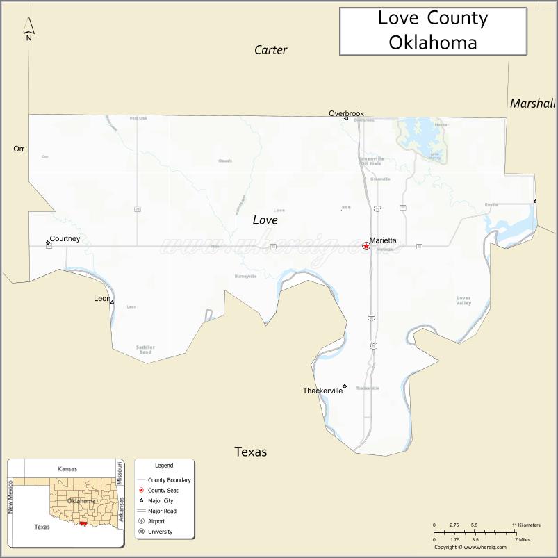
About Love County Map, Oklahoma: The map showing the county boundary, county seat, major cities, highways, water bodies and neighbouring counties.
Related Oklahoma Maps
About Love County, Oklahoma
Love County is a county located in the U.S. state of Oklahoma. It's county seat is Marietta. As per 2020 census, the population of Love County is 10216 people and population density is 19.84 square miles. According to the United States Census Bureau, the county has a total area of 515 sq mi (1,334 km2). Love County was established on 1907.
Love County Facts
| Continent | North America |
| Country | United States |
| State | Oklahoma |
| County Seat | Marietta |
| Largest City/Town | Marietta |
| Established | 1907 |
| Total Area | 532 sq mi (1,378 sq km) |
| Land Area | 514 sq mi (1,331 sq km) |
| Water Area | 18 sq mi (47 sq km) |
| Population | 10,146 (Census 2020) |
| Population Density | 19.7 people per sq mi |
| Time Zone | Central Time Zone (CST/CDT) |
| Major Highways | Interstate 35, U.S. Route 77, State Highway 32 |
| Major Rivers | Red River, Hickory Creek, Lake Murray nearby region |
| Neighboring Counties | Carter County, Marshall County, Jefferson County, Cooke County (Texas), Montague County (Texas) |
| Famous For | Lake Murray nearby region, Red River access, ranching, and southern Oklahoma recreation |
| Top Attractions | Lake Murray State Park nearby region, WinStar World Casino nearby region, Marietta historical sites, and outdoor recreation areas |
| Official Website | Official Website |
About Love County, Oklahoma
Love County is located in southern Oklahoma along the Texas border and was established in 1907 from former Chickasaw Nation territory. The county seat and largest city is Marietta. The county is known for ranching, recreation, Red River landscapes, and proximity to Lake Murray and major entertainment destinations.
Cities and Towns in Love County, Oklahoma
| City/Town | Population (Census 2020) | Latitude & Longitude |
|---|---|---|
| Marietta (county seat) | 2,717 | 33.9373°N, 97.1189°W |
| Thackerville | 445 | 33.7915°N, 97.1420°W |
| Burneyville | 603 | 33.9106°N, 97.2917°W |
| Leon | 91 | 33.8812°N, 97.4298°W |
| Greenville nearby region | 154 | 33.9836°N, 97.2883°W |
| Overbrook nearby area | 61 | 34.0454°N, 97.1287°W |
Golf Courses in Love County, Oklahoma
| Golf Course | Location | Latitude & Longitude |
|---|---|---|
| Lake Murray Golf Course nearby region | Lake Murray nearby region | 34.1248°N, 97.0873°W |
| Marietta Community Golf Area | Marietta | 33.9496°N, 97.1324°W |
| Red River Recreation Golf Area | Thackerville nearby region | 33.8041°N, 97.1548°W |
Major Roads and Highways in Love County, Oklahoma
Major highways connect Love County with Oklahoma City, Dallas-Fort Worth, and southern Oklahoma communities.
- Interstate 35 - major interstate connecting Oklahoma and Texas
- U.S. Route 77 - historic north-south transportation corridor
- State Highway 32 - regional transportation route serving southern Oklahoma
What are the Neighboring Counties of Love County
- Carter County (north)
- Marshall County (east)
- Jefferson County (west)
- Cooke County, Texas (south)
- Montague County, Texas (southwest)
What are the Top Places to Visit in Love County, Oklahoma
The county offers lakes, entertainment venues, prairie landscapes, and outdoor recreation opportunities.
- Lake Murray State Park nearby region - boating, fishing, hiking, and camping
- WinStar World Casino nearby region - entertainment, dining, and gaming destination
- Historic Downtown Marietta - local shops, restaurants, and heritage attractions
- Red River Recreation Areas - fishing, wildlife viewing, and outdoor activities
- Fishing and Wildlife Areas - birdwatching and family recreation opportunities
- Prairie Scenic Drives - countryside photography and ranching landscapes
- Community Rodeos and Festivals - western traditions and seasonal entertainment
- Camping and RV Parks - outdoor recreation and vacation destinations
- Agricultural Heritage Landscapes - farming and ranching scenery
- Nature Trails and Recreation Areas - hiking and environmental exploration
What is the Distance from Love County to Nearby Cities
The following distances are measured by road (driving).
- Marietta to Ardmore (Carter County), Oklahoma - 15 mi (24 km)
- Marietta to Gainesville (Cooke County), Texas - 18 mi (29 km)
- Marietta to Oklahoma City (Oklahoma County), Oklahoma - 107 mi (172 km)
- Marietta to Dallas (Dallas County), Texas - 82 mi (132 km)
- Marietta to Thackerville (Love County), Oklahoma - 10 mi (16 km)
- Marietta to Burneyville (Love County), Oklahoma - 14 mi (23 km)
- Marietta to Wichita Falls (Wichita County), Texas - 90 mi (145 km)
- Marietta to Tulsa (Tulsa County), Oklahoma - 161 mi (259 km)
- Marietta to Amarillo (Potter County), Texas - 320 mi (515 km)
- Marietta to Kansas City (Jackson County), Missouri - 414 mi (666 km)
- Marietta to Little Rock (Pulaski County), Arkansas - 288 mi (463 km)
- Marietta to Denver (Denver County), Colorado - 676 mi (1,088 km)
- Marietta to Chicago (Cook County), Illinois - 824 mi (1,326 km)
FAQs about Love County
Love County is located in southern Oklahoma along the Texas border.
Love County had a population of 10,146 according to the 2020 United States Census.
Love County is known for Lake Murray recreation, ranching, Red River landscapes, and nearby entertainment attractions.
The county is served by Interstate 35, U.S. Route 77, and State Highway 32.
Yes, Love County includes golf and recreation facilities near Lake Murray and Marietta.
References
- QuickFacts - U.S. Census Bureau
- United States Census Bureau
- United States Geological Survey (USGS)
- National Geodetic Survey
- Official Website
- Adair County Map
- Alfalfa County Map
- Atoka County Map
- Beaver County Map
- Beckham County Map
- Blaine County Map
- Bryan County Map
- Caddo County Map
- Canadian County Map
- Carter County Map
- Cherokee County Map
- Choctaw County Map
- Cimarron County Map
- Cleveland County Map
- Coal County Map
- Comanche County Map
- Cotton County Map
- Craig County Map
- Creek County Map
- Custer County Map
- Delaware County Map
- Dewey County Map
- Ellis County Map
- Garfield County Map
- Garvin County Map
- Grady County Map
- Grant County Map
- Greer County Map
- Harmon County Map
- Harper County Map
- Haskell County Map
- Hughes County Map
- Jackson County Map
- Jefferson County Map
- Johnston County Map
- Kay County Map
- Kingfisher County Map
- Kiowa County Map
- Latimer County Map
- Le Flore County Map
- Lincoln County Map
- Logan County Map
- Love County Map
- McClain County Map
- McCurtain County Map
- McIntosh County Map
- Major County Map
- Marshall County Map
- Mayes County Map
- Murray County Map
- Muskogee County Map
- Noble County Map
- Nowata County Map
- Okfuskee County Map
- Oklahoma County Map
- Okmulgee County Map
- Osage County Map
- Ottawa County Map
- Pawnee County Map
- Payne County Map
- Pittsburg County Map
- Pontotoc County Map
- Pottawatomie County Map
- Pushmataha County Map
- Roger Mills County Map
- Rogers County Map
- Seminole County Map
- Sequoyah County Map
- Stephens County Map
- Texas County Map
- Tillman County Map
- Tulsa County Map
- Wagoner County Map
- Washington County Map
- Washita County Map
- Woods County Map
- Woodward County Map
- Alabama Counties
- Alaska boroughs
- Arizona Counties
- Arkansas Counties
- California County Map
- Colorado Counties
- Connecticut Counties
- Delaware Counties
- Florida County Map
- Georgia County Map
- Hawaii Counties
- Idaho Counties
- Illinois Counties
- Indiana Counties
- Iowa Counties
- Kansas Counties
- Kentucky Counties
- Louisiana Counties
- Maine Counties
- Maryland Counties
- Massachusetts Counties
- Michigan County Map
- Minnesota Counties
- Mississippi Counties
- Missouri Counties
- Montana Counties
- Nebraska Counties
- Nevada Counties
- New York Counties
- New Hampshire Counties
- New Jersey Counties
- New Mexico Counties
- North Carolina Counties
- North Dakota Counties
- Ohio County Map
- Oklahoma Counties
- Oregon Counties
- Pennsylvania Counties
- Rhode Island Counties
- South Carolina Counties
- South Dakota Counties
- Map of Tennessee
- Texas County Map
- Utah Counties
- Vermont Counties
- Virginia Counties
- Washington Counties
- West Virginia Counties
- Wisconsin Counties
- Wyoming Counties