Written and Fact-checked by Whereig Editors, Reviewed by Mukesh Kumar| Updated On: May 15, 2026
Map of Bryan County - Bryan County is a county located in the U.S. state of Oklahoma. Bryan County Map showing cities, highways, important places and water bodies. Get Where is Bryan County located in the map, major cities in Bryan county, population, areas, and places of interest.
Map of Bryan County, Oklahoma
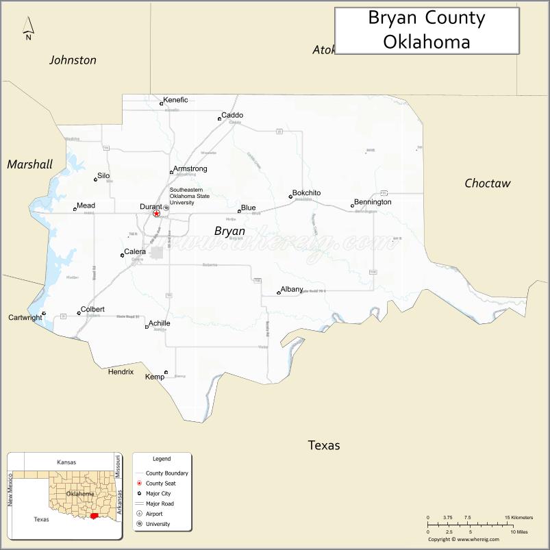
About Bryan County Map, Oklahoma: The map showing the county boundary, county seat, major cities, highways, water bodies and neighbouring counties.
Related Oklahoma Maps
About Bryan County, Oklahoma
Bryan County is a county located in the U.S. state of Oklahoma. It's county seat is Durant. As per 2020 census, the population of Bryan County is 47105 people and population density is 51.82 square miles. According to the United States Census Bureau, the county has a total area of 909 sq mi (2,354 km2). Bryan County was established on 1907.
Bryan County Facts
| Continent | North America |
| Country | United States |
| State | Oklahoma |
| County Seat | Durant |
| Largest City/Town | Durant |
| Established | 1907 |
| Total Area | 944 sq mi (2,445 sq km) |
| Land Area | 904 sq mi (2,341 sq km) |
| Water Area | 40 sq mi (104 sq km) |
| Population | 47,995 (Census 2020) |
| Population Density | 53.1 people per sq mi |
| Time Zone | Central Time Zone (CST/CDT) |
| Major Highways | U.S. Route 69, U.S. Route 75, U.S. Route 70, Oklahoma State Highway 78 |
| Major Rivers | Red River, Blue River, Lake Texoma nearby region |
| Neighboring Counties | Atoka County, Choctaw County, Johnston County, Marshall County, Grayson County (Texas) |
| Famous For | Choctaw Nation headquarters, Lake Texoma recreation, Southeastern Oklahoma State University, and Durant |
| Top Attractions | Lake Texoma nearby region, Choctaw Casino & Resort, Blue River recreation area, and Fort Washita Historic Site nearby region |
| Official Website | Official Website |
About Bryan County, Oklahoma
Bryan County is located in southeastern Oklahoma along the Texas border and was established in 1907 from former Choctaw Nation territory. The county seat and largest city is Durant. The county is known for Choctaw Nation culture, higher education, casino tourism, fishing, lakes, and outdoor recreation.
Cities and Towns in Bryan County, Oklahoma
| City/Town | Population (Census 2020) | Latitude & Longitude |
|---|---|---|
| Durant (county seat) | 18,589 | 33.9940°N, 96.3708°W |
| Caddo | 997 | 34.1370°N, 96.2647°W |
| Calera | 3,439 | 33.9340°N, 96.4281°W |
| Colbert | 1,140 | 33.8551°N, 96.5039°W |
| Bokchito | 650 | 34.0170°N, 96.1472°W |
| Bennington | 334 | 33.9993°N, 96.1078°W |
Golf Courses in Bryan County, Oklahoma
| Golf Course | Location | Latitude & Longitude |
|---|---|---|
| Chickasaw Pointe Golf Club | Kingston nearby region | 33.8197°N, 96.7072°W |
| Durant Country Club | Durant | 34.0049°N, 96.3846°W |
| Texoma Golf Course | Calera nearby region | 33.9448°N, 96.4407°W |
Major Roads and Highways in Bryan County, Oklahoma
Major highways connect Bryan County with Texas, Oklahoma City, and southeastern Oklahoma communities.
- U.S. Route 69 - major north-south transportation corridor through southeastern Oklahoma
- U.S. Route 75 - important highway linking Oklahoma and Texas
- U.S. Route 70 - east-west route serving southern Oklahoma communities
- Oklahoma State Highway 78 - regional connector near Lake Texoma
What are the Neighboring Counties of Bryan County
- Johnston County (northwest)
- Atoka County (north)
- Choctaw County (east)
- Marshall County (west)
- Grayson County, Texas (south)
What are the Top Places to Visit in Bryan County, Oklahoma
The county offers lake recreation, Choctaw cultural attractions, casinos, and outdoor destinations.
- Lake Texoma nearby region - boating, fishing, camping, and water recreation
- Choctaw Casino & Resort - gaming, entertainment, dining, and events
- Blue River Recreation Area - trout fishing, swimming, and hiking
- Fort Washita Historic Site nearby region - preserved military and frontier history
- Southeastern Oklahoma State University - education, athletics, and cultural events
- Historic Downtown Durant - shops, restaurants, and community attractions
- Fishing and Hunting Areas - outdoor recreation and wildlife observation
- Scenic Red River Countryside - prairie and river photography opportunities
- Community Festivals and Choctaw Events - cultural traditions and entertainment
- Camping and RV Parks - family recreation and lakeside relaxation
What is the Distance from Bryan County to Nearby Cities
The following distances are measured by road (driving).
- Durant to Sherman (Grayson County), Texas - 25 mi (40 km)
- Durant to Ardmore (Carter County), Oklahoma - 77 mi (124 km)
- Durant to McAlester (Pittsburg County), Oklahoma - 91 mi (146 km)
- Durant to Oklahoma City (Oklahoma County), Oklahoma - 153 mi (246 km)
- Durant to Calera (Bryan County), Oklahoma - 6 mi (10 km)
- Durant to Colbert (Bryan County), Oklahoma - 12 mi (19 km)
- Durant to Dallas (Dallas County), Texas - 96 mi (154 km)
- Durant to Tulsa (Tulsa County), Oklahoma - 171 mi (275 km)
- Durant to Fort Worth (Tarrant County), Texas - 118 mi (190 km)
- Durant to Little Rock (Pulaski County), Arkansas - 263 mi (423 km)
- Durant to Kansas City (Jackson County), Missouri - 343 mi (552 km)
- Durant to Memphis (Shelby County), Tennessee - 395 mi (636 km)
- Durant to Denver (Denver County), Colorado - 728 mi (1,171 km)
FAQs about Bryan County
Bryan County is located in southeastern Oklahoma along the Texas border.
Bryan County had a population of 47,995 according to the 2020 United States Census.
Bryan County is known for Choctaw Nation headquarters, Lake Texoma recreation, casinos, and Southeastern Oklahoma State University.
The county is served by U.S. Route 69, U.S. Route 75, U.S. Route 70, and Oklahoma State Highway 78.
Yes, Bryan County includes golf facilities such as Chickasaw Pointe Golf Club and Durant Country Club.
References
- QuickFacts - U.S. Census Bureau
- United States Census Bureau
- United States Geological Survey (USGS)
- National Geodetic Survey
- Official Website
- Adair County Map
- Alfalfa County Map
- Atoka County Map
- Beaver County Map
- Beckham County Map
- Blaine County Map
- Bryan County Map
- Caddo County Map
- Canadian County Map
- Carter County Map
- Cherokee County Map
- Choctaw County Map
- Cimarron County Map
- Cleveland County Map
- Coal County Map
- Comanche County Map
- Cotton County Map
- Craig County Map
- Creek County Map
- Custer County Map
- Delaware County Map
- Dewey County Map
- Ellis County Map
- Garfield County Map
- Garvin County Map
- Grady County Map
- Grant County Map
- Greer County Map
- Harmon County Map
- Harper County Map
- Haskell County Map
- Hughes County Map
- Jackson County Map
- Jefferson County Map
- Johnston County Map
- Kay County Map
- Kingfisher County Map
- Kiowa County Map
- Latimer County Map
- Le Flore County Map
- Lincoln County Map
- Logan County Map
- Love County Map
- McClain County Map
- McCurtain County Map
- McIntosh County Map
- Major County Map
- Marshall County Map
- Mayes County Map
- Murray County Map
- Muskogee County Map
- Noble County Map
- Nowata County Map
- Okfuskee County Map
- Oklahoma County Map
- Okmulgee County Map
- Osage County Map
- Ottawa County Map
- Pawnee County Map
- Payne County Map
- Pittsburg County Map
- Pontotoc County Map
- Pottawatomie County Map
- Pushmataha County Map
- Roger Mills County Map
- Rogers County Map
- Seminole County Map
- Sequoyah County Map
- Stephens County Map
- Texas County Map
- Tillman County Map
- Tulsa County Map
- Wagoner County Map
- Washington County Map
- Washita County Map
- Woods County Map
- Woodward County Map
- Alabama Counties
- Alaska boroughs
- Arizona Counties
- Arkansas Counties
- California County Map
- Colorado Counties
- Connecticut Counties
- Delaware Counties
- Florida County Map
- Georgia County Map
- Hawaii Counties
- Idaho Counties
- Illinois Counties
- Indiana Counties
- Iowa Counties
- Kansas Counties
- Kentucky Counties
- Louisiana Counties
- Maine Counties
- Maryland Counties
- Massachusetts Counties
- Michigan County Map
- Minnesota Counties
- Mississippi Counties
- Missouri Counties
- Montana Counties
- Nebraska Counties
- Nevada Counties
- New York Counties
- New Hampshire Counties
- New Jersey Counties
- New Mexico Counties
- North Carolina Counties
- North Dakota Counties
- Ohio County Map
- Oklahoma Counties
- Oregon Counties
- Pennsylvania Counties
- Rhode Island Counties
- South Carolina Counties
- South Dakota Counties
- Map of Tennessee
- Texas County Map
- Utah Counties
- Vermont Counties
- Virginia Counties
- Washington Counties
- West Virginia Counties
- Wisconsin Counties
- Wyoming Counties