Written and Fact-checked by Whereig Editors, Reviewed by Mukesh Kumar| Updated On: May 15, 2026
Map of Kay County - Kay County is a county located in the U.S. state of Oklahoma. Kay County Map showing cities, highways, important places and water bodies. Get Where is Kay County located in the map, major cities in Kay county, population, areas, and places of interest.
Map of Kay County, Oklahoma
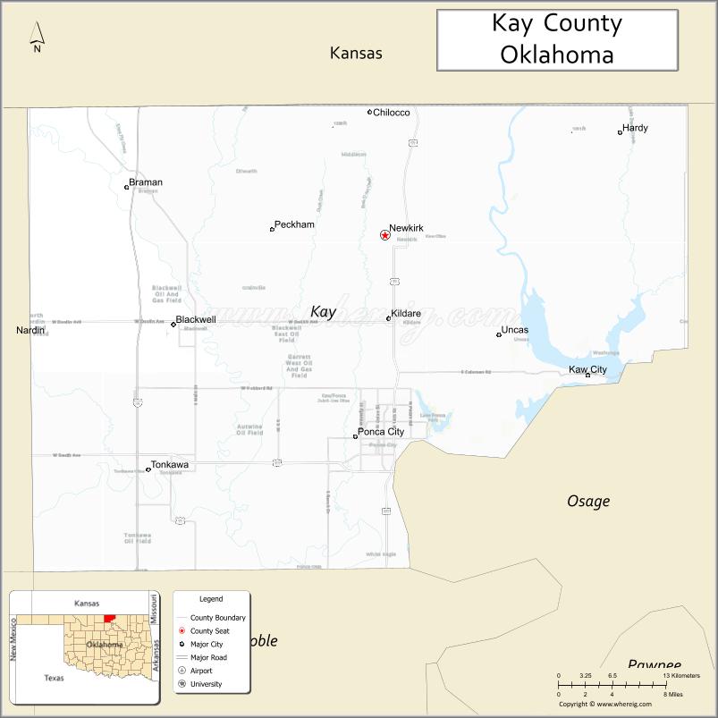
About Kay County Map, Oklahoma: The map showing the county boundary, county seat, major cities, highways, water bodies and neighbouring counties.
Related Oklahoma Maps
About Kay County, Oklahoma
Kay County is a county located in the U.S. state of Oklahoma. It's county seat is Newkirk. As per 2020 census, the population of Kay County is 43732 people and population density is 47.59 square miles. According to the United States Census Bureau, the county has a total area of 919 sq mi (2,380 km2). Kay County was established on 1895.
Kay County Facts
| Continent | North America |
| Country | United States |
| State | Oklahoma |
| County Seat | Newkirk |
| Largest City/Town | Ponca City |
| Established | 1893 |
| Total Area | 945 sq mi (2,448 sq km) |
| Land Area | 920 sq mi (2,383 sq km) |
| Water Area | 25 sq mi (65 sq km) |
| Population | 43,700 (Census 2020) |
| Population Density | 47.5 people per sq mi |
| Time Zone | Central Time Zone (CST/CDT) |
| Major Highways | Interstate 35, U.S. Route 77, U.S. Route 60, State Highway 11 |
| Major Rivers | Arkansas River, Chikaskia River, Salt Fork Arkansas River |
| Neighboring Counties | Cowley County (Kansas), Sumner County (Kansas), Osage County, Noble County, Grant County |
| Famous For | Ponca City, oil industry history, Marland Mansion, and north-central Oklahoma heritage |
| Top Attractions | Marland Mansion, Pioneer Woman Museum, Kaw Lake nearby region, and Ponca City cultural attractions |
| Official Website | Official Website |
About Kay County, Oklahoma
Kay County is located in north-central Oklahoma along the Kansas border and was established during the Cherokee Outlet Land Run of 1893. The county seat is Newkirk, while Ponca City is the largest city. The county is known for oil industry history, Native American heritage, agriculture, and cultural attractions.
Cities and Towns in Kay County, Oklahoma
| City/Town | Population (Census 2020) | Latitude & Longitude |
|---|---|---|
| Ponca City | 24,424 | 36.7069°N, 97.0856°W |
| Newkirk (county seat) | 2,207 | 36.8820°N, 97.0539°W |
| Blackwell | 6,085 | 36.8045°N, 97.2820°W |
| Tonkawa | 2,852 | 36.6803°N, 97.3098°W |
| Kaw City | 356 | 36.7642°N, 96.9892°W |
| Braman | 217 | 36.9206°N, 97.3348°W |
Golf Courses in Kay County, Oklahoma
| Golf Course | Location | Latitude & Longitude |
|---|---|---|
| Ponca City Country Club | Ponca City | 36.7286°N, 97.0687°W |
| Wentz Memorial Golf Course | Ponca City | 36.6954°N, 97.0738°W |
| Tonkawa Golf Course | Tonkawa | 36.6901°N, 97.3215°W |
Major Roads and Highways in Kay County, Oklahoma
Major highways connect Kay County with Kansas, Oklahoma City, Tulsa, and north-central Oklahoma communities.
- Interstate 35 - major interstate connecting Oklahoma City and Kansas
- U.S. Route 77 - historic north-south transportation route
- U.S. Route 60 - important east-west corridor across northern Oklahoma
- State Highway 11 - regional highway serving agricultural and rural areas
What are the Neighboring Counties of Kay County
- Cowley County, Kansas (north)
- Sumner County, Kansas (northwest)
- Osage County (east)
- Noble County (south)
- Grant County (west)
What are the Top Places to Visit in Kay County, Oklahoma
The county offers museums, lakes, cultural attractions, and outdoor recreation opportunities.
- Marland Mansion - historic mansion built by oil pioneer E.W. Marland
- Pioneer Woman Museum - exhibits on Oklahoma pioneer history and culture
- Kaw Lake nearby region - boating, fishing, camping, and recreation activities
- Standing Bear Park - Native American heritage and sculpture displays
- Historic Downtown Ponca City - shopping, restaurants, and entertainment venues
- Poncan Theatre - restored historic performing arts venue
- Fishing and Wildlife Areas - outdoor recreation and birdwatching opportunities
- Community Festivals and Rodeos - local traditions and seasonal entertainment
- Prairie Scenic Drives - countryside photography and agricultural landscapes
- Camping and RV Parks - lakeside recreation and family outdoor activities
What is the Distance from Kay County to Nearby Cities
The following distances are measured by road (driving).
- Ponca City to Wichita (Sedgwick County), Kansas - 72 mi (116 km)
- Ponca City to Stillwater (Payne County), Oklahoma - 46 mi (74 km)
- Ponca City to Enid (Garfield County), Oklahoma - 54 mi (87 km)
- Ponca City to Tulsa (Tulsa County), Oklahoma - 102 mi (164 km)
- Ponca City to Newkirk (Kay County), Oklahoma - 12 mi (19 km)
- Ponca City to Blackwell (Kay County), Oklahoma - 22 mi (35 km)
- Ponca City to Oklahoma City (Oklahoma County), Oklahoma - 101 mi (163 km)
- Ponca City to Kansas City (Jackson County), Missouri - 245 mi (394 km)
- Ponca City to Dallas (Dallas County), Texas - 283 mi (455 km)
- Ponca City to Amarillo (Potter County), Texas - 258 mi (415 km)
- Ponca City to Denver (Denver County), Colorado - 503 mi (809 km)
- Ponca City to Little Rock (Pulaski County), Arkansas - 361 mi (581 km)
- Ponca City to Chicago (Cook County), Illinois - 676 mi (1,088 km)
FAQs about Kay County
Kay County is located in north-central Oklahoma along the Kansas border.
Kay County had a population of 43,700 according to the 2020 United States Census.
Kay County is known for Ponca City, oil industry history, Marland Mansion, and Native American heritage.
The county is served by Interstate 35, U.S. Route 77, U.S. Route 60, and State Highway 11.
Yes, Kay County includes golf facilities such as Ponca City Country Club and Wentz Memorial Golf Course.
References
- QuickFacts - U.S. Census Bureau
- United States Census Bureau
- United States Geological Survey (USGS)
- National Geodetic Survey
- Official Website
- Adair County Map
- Alfalfa County Map
- Atoka County Map
- Beaver County Map
- Beckham County Map
- Blaine County Map
- Bryan County Map
- Caddo County Map
- Canadian County Map
- Carter County Map
- Cherokee County Map
- Choctaw County Map
- Cimarron County Map
- Cleveland County Map
- Coal County Map
- Comanche County Map
- Cotton County Map
- Craig County Map
- Creek County Map
- Custer County Map
- Delaware County Map
- Dewey County Map
- Ellis County Map
- Garfield County Map
- Garvin County Map
- Grady County Map
- Grant County Map
- Greer County Map
- Harmon County Map
- Harper County Map
- Haskell County Map
- Hughes County Map
- Jackson County Map
- Jefferson County Map
- Johnston County Map
- Kay County Map
- Kingfisher County Map
- Kiowa County Map
- Latimer County Map
- Le Flore County Map
- Lincoln County Map
- Logan County Map
- Love County Map
- McClain County Map
- McCurtain County Map
- McIntosh County Map
- Major County Map
- Marshall County Map
- Mayes County Map
- Murray County Map
- Muskogee County Map
- Noble County Map
- Nowata County Map
- Okfuskee County Map
- Oklahoma County Map
- Okmulgee County Map
- Osage County Map
- Ottawa County Map
- Pawnee County Map
- Payne County Map
- Pittsburg County Map
- Pontotoc County Map
- Pottawatomie County Map
- Pushmataha County Map
- Roger Mills County Map
- Rogers County Map
- Seminole County Map
- Sequoyah County Map
- Stephens County Map
- Texas County Map
- Tillman County Map
- Tulsa County Map
- Wagoner County Map
- Washington County Map
- Washita County Map
- Woods County Map
- Woodward County Map
- Alabama Counties
- Alaska boroughs
- Arizona Counties
- Arkansas Counties
- California County Map
- Colorado Counties
- Connecticut Counties
- Delaware Counties
- Florida County Map
- Georgia County Map
- Hawaii Counties
- Idaho Counties
- Illinois Counties
- Indiana Counties
- Iowa Counties
- Kansas Counties
- Kentucky Counties
- Louisiana Counties
- Maine Counties
- Maryland Counties
- Massachusetts Counties
- Michigan County Map
- Minnesota Counties
- Mississippi Counties
- Missouri Counties
- Montana Counties
- Nebraska Counties
- Nevada Counties
- New York Counties
- New Hampshire Counties
- New Jersey Counties
- New Mexico Counties
- North Carolina Counties
- North Dakota Counties
- Ohio County Map
- Oklahoma Counties
- Oregon Counties
- Pennsylvania Counties
- Rhode Island Counties
- South Carolina Counties
- South Dakota Counties
- Map of Tennessee
- Texas County Map
- Utah Counties
- Vermont Counties
- Virginia Counties
- Washington Counties
- West Virginia Counties
- Wisconsin Counties
- Wyoming Counties